Parcel Prospectivity
 Potential traps – There are wide variations in potential structural and stratigraphic traps in Parcels 3, 4, 5, and 6. The southern parts of Parcels 3 and 4, the eastern part of Parcel 5, and most of Parcel 6 lie above the ASM province where the most obvious traps are associated with allochthonous salt bodies (diapirs and walls) or intervening minibasins that have undergone varying degrees of squeezing.
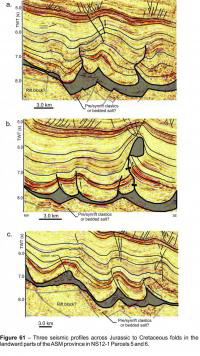
 In Parcels 5 and 6, thrust propagation folds, salt cored detachment folds, and reverse faults are common and several potential traps were described in the NS08-2 Call-for-Bids package (Figures 52 and 53) Shortening in these parcels appears to be associated to two overlapping linked extensional-contractional systems (Deptuck et al., 2009). The first is oriented normal to the margin hinge zone (northwest-southeast shortening) where folding was driven by thin-skinned detachment of cover strata above the autochthonous salt layer landward of the ASM province (within the SD province, prompted by oversteepening of the margin; Deptuck, 2011a), and the second is oriented parallel to the dominant direction of Early Cretaceous sediment input from the westernmost ‘Sable Island Delta’ (north-south shortening direction) (Deptuck et al., 2009). Most potential traps in Parcels 5 and 6 either form 3-way closures against salt feeders or fault welds, or are associated with folds that require closure of some sort against salt (e.g. the “Big Tancook” and “Crows Neck” structures in Parcel 6 and the “Big Thrum” structure in parcel 5)(Figure 61). Some of these structures cover areas greater than 25 km2 while most are smaller but could have three-way closure at multiple Cretaceous through Cenozoic stratigraphic levels.
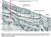
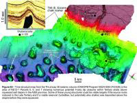
 Numerous potential four-way dip closures are present above salt diapirs in the ASM province in Parcels 3, 4, 5, and 6 (Figures 59, 62, 63). They are commonly associated with younger periods of contraction that squeezed salt stocks and folded overlying Cenozoic strata. Some structures show strong evidence for direct hydrocarbon indicators (DHIs) like flat spots, anomalously high amplitude seismic reflections, and gas chimneys. Some of these young structures could be viable targets if source rocks continued to expel hydrocarbons into the Late Tertiary and if a viable reservoir (turbidites, but potentially also porous chalks) was deposited above the diapirs before they were squeezed.
Significant portions of Parcels 3, 4, and 5 are located seaward of the margin hinge zone and within the SD province (Figure 59). A number of potential structural and stratigraphic traps are possible here. Most potential structural traps involve Jurassic to Earliest Cretaceous strata and are associated with rotation of rafts above the autochthonous salt layer, in some cases influenced by the rugose faulted geometry of the rocks that underlie the salt. The raised edges of Jurassic rafts locally form angular discordances that are draped by Cretaceous strata. Such structures could form unconformity traps. There is also potential for stratigraphic traps (Figure 62). The shingled high to moderate amplitude seismic response in the “Bella” lead in Parcel 5 (described in the NS08-2 Call-for-Bids package, figure 27) may have been produced from alternating clastic submarine fans and slope carbonates that pinch out onto the steep carbonate foreslope. These deposits could be analogous to the Buzzard field in the North Sea, which contains 400 million barrels of oil in Late Jurassic reservoirs that form a wedge-shaped stratigraphic trap that thins onto the slope. The Bella lead extends for more than 22 km along strike, with its highest amplitude parts covering more than 60 km2 near its upslope termination, but this Upper Jurassic lead may be too deeply buried (6 sec twt). Shallower stratigraphic traps associated with Cenozoic turbidites that onlap the steep slope in the SD province (Parcels 3, 4, and 5) or accumulated above a step on the gradient profile constructed during aggradation of Neogene contourites (see Campbell, 2011; Campbell and Deptuck, 2012) may be more reasonable targets. Some of these onlap traps are associated with strong amplitude anomalies, though as Torbrook C-15 has shown, some amplitude anomalies correspond to poorly consolidated low-velocity siltstone (Kidston et al., 2007).
Potential reservoirs – Most of the reservoir potential in NS12-1 Parcels 3, 4, 5, and 6 are likely to be associated with turbidites that onlap the slope or were incorporated into Upper Jurassic to Tertiary salt-related structures. Based on regional sediment thickness maps, correlation of shelf-edge trajectories, and identification of canyons, the ‘Sable Island Delta’ is the most likely source for Lower Cretaceous turbidites in Parcels 5 and 6 (and other deepwater parcels to the east) (see Figure 3). In contrast, Lower Cretaceous strata (Berriasian to early Aptian) are condensed above the LaHave Platform west of Mohican I-100 (Figure 59), and largely represented by carbonates with intervening clastics of the Roseway Unit (Wade and MacLean, 1990), though it is possible that a heavily eroded Albian succession supplied deepwater sands to Parcels 3 and 4. Upper Cretaceous to Oligocene top-set to fore-set progradational packages are also present landward of Parcels 3 and 4, and such units could have supplied sands into deepwater.
The reader is directed to Deptuck (2011a) and Deptuck (2011b) (www.novascotiaoffshore.com/data) for a more comprehensive description of potential shelf sources for deepwater reservoirs along the western part of the margin.
Source rock potential – According to the Play Fairway Study (OETR, 2011), there is evidence for a Lower Jurassic oil prone source rock above the autochthonous salt basin along the western half of the margin. This conclusion is based on a number of observations including the analysis of oils found in several piston cores. Petroleum system modeling indicates that oil expulsion continues today along the southwestern Scotian Slope where the Lower Jurassic section is found at relatively shallow burial depths (compared to the Sable Subbasin region). As such, even young traps, like late Cenozoic strata that were folded above salt diapirs, could be viable plays. The reader is directed to the Play Fairway Study (OETR, 2011) for a more detailed account of this interpretation.