An Environmental Assessment (EA) is required as part of the activity authorization for exploration and development programs in the Nova Scotia Offshore. The EA process predicts environmental effects of proposed physical activities before they are carried out. EAs identify potential adverse environmental effects, propose measures to mitigate adverse environmental effects, predict whether there will be significant adverse environmental effects after mitigation measures are implemented, and include a follow-up program to verify the accuracy of the environmental assessment and the effectiveness of the mitigation measures.
EAs in the Nova Scotia offshore area are governed by the Federal/provincial Accord Acts and the Canadian Environmental Assessment Act, 2012 (CEAA 2012). Part III of the Accord Acts promotes environmental protection. Accord Act EA processes include application to seismic programs. CEAA 2012 applies to “Designated Projects” as defined by that law, namely exploration drilling programs, development programs and some decommissioning programs.
Strategic Environmental Assessments (SEAs) which encompass the parcel areas were completed in 2012. It is recommended that these SEAs are used by operators to assist in the preparation of project specific environmental assessments.
EASTERN SCOTIAN SHELF AND SLOPE - MIDDLE AND SABLE ISLAND BANKS http://www.cnsopb.ns.ca/environment/environmental-assessments/file-no-753457
WESTERN SCOTIAN SHELF AND SLOPE - AREA 3A http://www.cnsopb.ns.ca/environment/environmental-assessments/public-registry-sea/file-no-7534575
WESTERN SCOTIAN SHELF AND SLOPE - AREA 3B http://www.cnsopb.ns.ca/environment/environmental-assessments/public-registry-sea/file-no-7534576
Species at Risk
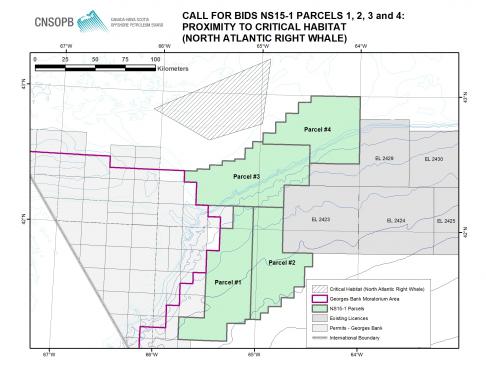
Parcels 3 and 4 are located adjacent to the critical habitat of the North Atlantic right whale, listed as Schedule 1 Endangered under the Species at Risk Act (SARA). Any approved activity with an increased likelihood of interaction with this species may require enhanced mitigation and may include certain limitations to avoid the destruction of critical habitat. Project specific EAs will be required to address this increased potential for interaction. Bidders are also strongly encouraged to gain an understanding of the Species at Risk Act, which is enforced by DFO, Environment Canada. The Act is available by clicking here: http://laws-lois.justice.gc.ca/eng/acts/S-15.3/index.html.
Statement of Canadian Practice with Respect to the Mitigation of Seismic Sound in the Marine Environment (the Statement)
The mitigative measures contained in this Statement were developed based on available scientific knowledge and are considered to be current best practice for minimizing potential adverse impacts of seismic activities that use air source arrays. The statement is taken into account during regulatory reviews which include the environmental assessment processes. Operators of seismic operations will be required to provide rationale for any modifications or variations to the mitigative measures that are set out in the Statement for consideration by the CNSOPB. The Statement and a background paper are available at http://www.dfo-mpo.gc.ca/oceans/management-gestion/integratedmanagement-gestionintegree/seismic-sismique/index-eng.asp.
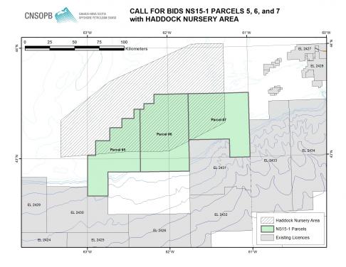
As noted above, any approved activity near critical habitat areas may require enhanced mitigation above and beyond the Statement. As well, the Lands include a known spawning area for Haddock known as the “Haddock Box”. Any approved activity within or near this area may require enhanced mitigation and may require certain limitations to avoid dispersing aggregations of spawning fish in accordance with the Statement.
Sable Island National Park Reserve
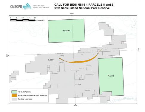
Parcels 8 and 9 are adjacent to Sable Island. Sable Island is a federally protected National Park Reserve as well as a nesting area for bird species at risk, including the endangered Roseate Tern. Both parcels are located beyond the drilling exclusion zone of 1 nautical mile seaward of the low water mark of Sable Island.


