Discussion – Structural and Stratigraphic Evolution of the Eastern Scotian Slope
Discussion – Structural and Stratigraphic Evolution of the Eastern Scotian Slope
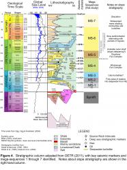
Mega-sequences 1 through 7 track important broad-scale sedimentary and/or structural changes on the eastern Scotian Slope. Ties to equivalent shelf successions, coupled with the use of salt contact maps, reconstruction of shelf-edge trajectories, and mapping of sediment thickness and structural trends, provide important insights into the structural and stratigraphic evolution of the eastern Scotian margin.
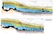
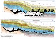
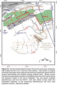
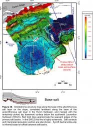
Basement rocks below the eastern Scotian Slope, whatever their origin, were flanked by two primary salt basins: the Huron Subbasin to the northwest (below the present-day outer shelf) and the SWLS to the northeast (below the present day slope). The narrow and elongated Huron Subbasin is a large graben that is reasonably well constrained on seismic profiles. It is floored by faulted synrift clastics that gave way vertically to salt (see profiles D1 to D4; Figs. 10, 11), and is flanked in the seaward direction by the SGR, a probable horst block. Based on its landward position relative to the ECMA, the SGR is probably comprised of continental crust. The SWLS in contrast is poorly constrained on seismic profiles. The base salt and top basement surfaces appear to step deeper towards the SWLS (on time-structure maps; e.g. Fig. 30), but seismic imaging of the crust below this basin is very poor. As such, the placement of the original western and southern margins of the salt basin is highly speculative (Figs. 16, 30). The dextral (right-lateral) offset between these two salt basins presumably took place during rifting, across a relatively important transform fault zone, but this cannot be confirmed with existing data.
Because the age and origin of basement rocks to the southeast and southwest of the Huron Subbasin and SWLS, respectively, is uncertain, so too is the age of MS-1. If the highly rugose faulted basement rocks correspond to thin slow spreading oceanic crust above partially serpentinized mantle (our preferred interpretation, and consistent with Louden et al., 2012), then the interval immediately above it is probably equivalent to the earliest postrift sediments on the Scotian margin. In this scenario, MS-1 could be a distal equivalent of the Mohican Formation (Fig. 4) that accumulated passively in the Early to early Middle Jurassic in an area far removed from early river systems that continued to erode the rift shoulder at this time. Onlap of these deposits filled and smoothed over the steep rugged terrane produced by the early oceanic (or transitional) crust. Overall, MS-1 thins in both the seaward direction beneath to Sohm Abyssal Plain and in the landward direction towards the SGR, indicating that at a more regional scale MS-1 was deposited within a sag located between more elevated basement elements in both the landward and seaward directions. The 1.0 to 1.6 km high peaks produced by some rotated fault blocks near the centre of this sag were largely filled in by the J175 marker at the top of MS-1.
MS-2 records the first pulse of more active sedimentation on the eastern Scotian Slope. Based on their distribution, MS-2 sediments appear to have been sourced from the northeast. Like MS-1, their age is uncertain, but the Bandol No. 1 well located 140 km to the northeast penetrated a several hundred meter thick intervals of Middle Jurassic (Bathonian to Callovian) sandstone, indicating that an active sediment delivery system was present in the Laurentian Subbasin prior to the Callovian. An early pulse of coarse sediment from this direction, towards the SWLS, is consistent with the thickness distribution of MS-2. MS-2 strata accumulated in front of salt that had begun to inflate and flow out of the SWLS, implying that the more proximal salt basin was also actively loaded at this time. At the same time, salt contacts indicate that salt flowed at least 45 km out of the Huron Subbasin and across the SGR (Ings and Shimeld, 2006), probably mostly during the latter parts of MS-2. Expulsion of this salt was triggered by Middle Jurassic sediment loading coupled with margin tilting in response to thermal subsidence (Shimeld, 2004; Ings and Shimeld, 2006; Albertz et al. 2010). As such, by the end of MS-2, two salt fronts were impinging on the eastern Scotian Slope from two directions (Fig. 16).
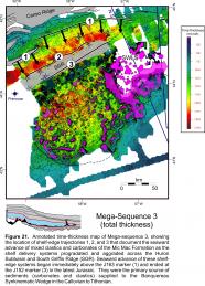
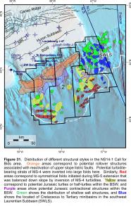
A westward shift in sediment delivery is recorded by well-developed progradation above the J163 marker along the northern margin of the Huron Subbasin in the early stages of MS-3 (Figs. 16, 21). Down-building in the Huron Subbasin was contemporaneous with the growth of the BSW. Mixed clastics and carbonates of the Mic Mac Formation were initially focused along the axis of the Huron Subbasin, and the wide spacing between early salt contacts seaward of the SGR implies that salt flowed rapidly down the slope relative to sedimentation aggradation in the early part of MS-3 (Fig. 16). Early slope sedimentation above the expelled salt was in the form of minibasins and roho systems. Some minibasins inverted to form turtles or half-turtles, as the early basins touched down onto a salt weld. Contemporaneous seaward translation of the BSW above the salt detachment, however, transported many of the early turtles seaward, where they are clustered along marginal areas of the BSW (Fig. 31). Subtle contractional features formed locally at the same time, but most shortening was accommodated through the narrowing of salt bodies.
The pattern of sediment thickness preserved below the central and western parts of the salt detachment, used together with salt contact maps, implies that salt advanced somewhat unevenly down the slope as two or three separate tongues, with the eastern salt tongue advancing towards the southeast ahead of the others (Fig. 16). At the same time, salt continued to flow, at a slower rate, out of the SWLS and away from the J163 salt contact. A ridge of thicker sub-salt strata is preserved along the boundary between these advancing salt fronts, where sediment accumulated along an open corridor that remained uncovered by salt for a longer period of time (relative to immediately adjacent areas). This ridge separates the central and western parts of the BSW from its eastern part. A final salt suture probably formed somewhere above this sediment ridge as the two salt fronts converged prior to the extinction of the BSW. Detachment along the base of the BSW appears to have taken place above salt from both subbasins, and the J150 salt contact along the seaward boundary of the BSW still shows an indentation where salt from these two subbasins merged (Fig. 16).
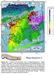
The latest Jurassic Avalon Uplift at the onset of MS-4 coincides with a change in shelf lithofacies, where the mixed clastics and carbonates of the Mic Mac Formation were replaced by coarse siliciclastics of the Missisauga Formation (Wade and MacLean, 1990). The initiation of the Avalon Uplift is regarded as late Kimmeridgian in the Jeanne d’Arc Basin (Grand Banks of Newfoundland), with uplift continuing into the Barremian (McAlpine, 1990). Uplift has been attributed to renewed rifting between the Grand Banks and Iberia, and sedimentation rates into the Jeanne d’Arc Basin reportedly doubled after uplift began, a time when some of the most important reservoirs were deposited in the Jeanne d’Arc Basin (McAlpine, 1990). On the eastern Scotian shelf, the onset of Avalon Uplift marks the end of down-building into the Huron Subbasin, with sedimentation focused seaward of the SGR. On the eastern Scotian slope, the onset of Avalon Uplift marks the termination of the BSW and the onset of the Missisauga fan complex. The exact relationship between the Avalon Uplift and the transitional interval on the slope between the J152 marker and the prominent unconformity near the base of MS-4 is unclear. The interval may record an initial period of slope regrading in response to a change in the slope profile induced by shelf uplift. A noticeable westward shift away from the southwestern flank of the Avalon Uplift is recorded in MS-4 (Fig. 22) with increased sediment accumulation seaward of the BSW buttressing the salt along its distal margins.
The abrupt seaward shift in MS-5 shelf-edge clinoforms in the Albian and Cenomanian, despite the overall aggradational character of shelf strata at this time, is a testament to the continued ample supply of clastic sediments to the margin after late Aptian flooding (although on average with a lower net-to-gross than the underlying Missisauga Formation). At no other time before or since, going back as far as the break-up between Morocco and Nova Scotia, has the continental shelf edge been located further seaward than it was during this period. Even the modern continental shelf edge is located at least 20 km landward of this Albian-Cenomanian maximum regression, which today sits beneath more than 1500 m of water. Significantly more sediment was stored on the shelf however, than on the slope during MS-5. On the slope there is a marked change in submarine fan architecture that coincides with the abrupt Early Albian seaward shift in the shelf edge. The slope is dominated by empty canyons flanked by wedge-shaped inter-canyon highs or levees of the Shortland fan complex. This implies that the lack of sediment storage on the slope during MS-5 (compared, for example, to MS-4) is the result of erosion and sediment bypass of at least the coarse fraction of flows across the slope, rather than sediment starvation. Coarser-grained submarine fan deposits must have accumulated somewhere seaward of these canyons, beyond the limits of our study area.
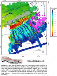
Although growth across outer shelf listric faults is recorded within MS-4, it was not until MS-5 that growth faults on the upper slope were balanced by shortening on the lower slope. MS-5 is the first interval to show clear thinning above the salt-cored toe folds that inverted MS-4 turbidites above the seaward part of the BSW (Fig. 25). The abrupt change from aggradational channel-levee systems in the Missisauga fan complex to bypassing canyons flanked by levees in the Shortland fan system, coupled with the timing of the onset of folding of MS-4 strata above the toe of the BSW, might indicate that the slope began to steepen during deposition of MS-5. This would explain the change in submarine fan architecture and perhaps why, despite the clear growth across listric faults during MS-4 immediately upslope from the BSW, there is no evidence of the onset of folding of MS-4 strata until MS-5. We are not sure what would cause the slope to steepen, but a late Aptian to early Albian volcanic center has been described near the Orpheus Graben northwest of the study area (Bowman et al., 2012). Volcanism here coincides with the onset of MS-5 so perhaps there is an indirect relationship between this event and the abrupt change in fan architecture in the study area.
Preferential storage of sediments on the shelf continued during MS-6, when a period of generally high sea level and reduced sediment supply pushed rivers far back from the MS-5 continental shelf edge. Numerous regressions in the latest Cretaceous, Paleocene, and Eocene produced local build-outs of delta lobes with sandy topsets and muddy clinoforms, but these did not advance beyond the outer shelf. More time is recoded in MS-6 (~60 Ma) than any other mega-sequence described in this report, yet even less sediment accumulated on the slope than during MS-5, over a time span that lasted three times longer. Accumulation of weak, water-saturated chalks appear to have pre-conditioned the slope for failure, and numerous slumps, periods of slope detachments, and merged unconformities are all recorded within this thin slope succession. In contrast to MS-5, the lack of sediment stored on the slope during MS-6 probably reflects a combination of sediment starvation and slope bypass. The outer shelf subsided during MS-6, and the nucleation of slope failures and shallow detachment faults immediately above the MS-5 shelf edge (the maximum regression of the margin) could reflect a broader scale attempt by MS-6, followed by MS-7 depositional systems, to regrade the slope.
Finally, MS-7 records a sharp change back to slope-dominated sedimentation, with thick outer shelf and slope deposits comprised of turbidites, contourite drifts, and widespread mass transport deposits. The Laurentian Fan was deposited during this interval, and periods of shelf-crossing glaciation strongly affected slope sedimentation (see Piper et al., 2012).

