Introduction and Scope
Introduction and Scope
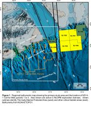
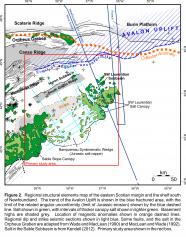
This report summarizes the Mesozoic to early Cenozoic geological evolution of the eastern Scotian Slope, between The Gully (a large submarine canyon that bisects the shelf and slope just east of Sable Island), and the Laurentian Channel (a 100 km wide shelf-crossing trough that formed during Quaternary advance and retreat of glacial ice; Piper et al., 2012) (Fig. 1). The primary objective is to provide geological context for Parcels 1 through 4 in the CNSOPB NS14-1 Call for Bids. The Call area is best known geologically for a unique structural element known as the “Banquereau Synkinematic Wedge” (BSW; Shimeld, 2004). The BSW is a large Middle to Late Jurassic (Ings and Shimeld, 2006) or earliest Cretaceous (OETR, 2011) salt-based detachment overlain by a range of potential hydrocarbon-bearing structures that include roho systems, inverted minibasins, and rim synclines that were variably transported down the slope and compressed during at least two periods of shortening. The Call area also crosses an important geological boundary, where the BSW and the allochthonous salt along its base are juxtaposed with a primary (autochthonous) salt basin to the northeast (the southwestern Laurentian Subbasin; SWLS)(Fig. 2). Although much of the salt in the BSW was supplied from a primary salt basin to the northwest (the Huron Subbasin; CNSOPB, 2013), the salt-based detachment in the eastern part of the BSW appears to have developed above salt that was expelled from the SWLS. Salt-related structures in the SWLS are complex, with stepped counter-regional systems and seaward leaning feeders expelling salt into a large salt-stock or salt-tongue canopy that was subsequently re-loaded and variably squeezed. As many as three tiers of allochthonous salt are present here, creating a wide variety of potential trap configurations, but also substantially degrading seismic imaging across much of the SWLS.
We provide a detailed account of the stratigraphic and structural evolution of the eastern Scotian Slope before, during, and after development of the BSW, and the co-evolution of the SWLS to its east. We also attempt to link the broad-scale structural and seismic stratigraphic changes in the NS14-1 Call area on the slope to the development of shelf depositional systems that have been calibrated with wells landward of the Call area (and described in CNSOPB, 2013). Particular focus is placed on the distribution, timing and style of potential hydrocarbon-bearing structures and potential reservoir intervals on the slope.
Study Area and Location of NS14-1 Parcels 1 to 4
The primary study area for this report includes the outermost Scotian Shelf, Scotian Slope, and proximal Sohm Abyssal Plain (Figs. 1, 2). NS14-1 Parcels 1 to 4 are located in the southern half of the study area, principally on the modern continental slope. Parcels 1 and 2 are located on the upper to lower slope in the western Call area, in water depths ranging from about 150 to 4100 m. They cover the proximal to distal reaches of the BSW. Parcel 3 is located on the upper to middle slope and covers the SWLS, in water depths ranging from about 100 to 3100 m. Parcel 4 is located on the middle to lower slope in water depths ranging from 2200 to 4100 m. It covers a complex region of suturing and salt expulsion from both the BSW and the SWLS. Both Parcels 3 and 4 border the Nova Scotia – Newfoundland and Labrador jurisdictional boundary, adjacent to active C-NLOPB exploration licenses (Fig. 1).
Acknowledgements
This report forms part of an ongoing long-term CNSOPB effort focused on unravelling the complex structural and stratigraphic history of the Scotian margin, as part of our mandate to better understand the resource potential in the Nova Scotia offshore area. Brian Altheim is thanked for logistical assistance and we are grateful to Carl Makrides and CNSOPB management for their strong support of geoscience initiatives. OERA is thanked for permission to use figure 32, which was adapted from figures published in the Play Fairway Atlas (OETR, 2011).


