Geological Setting and Previous Work
Geological Setting and Previous Work
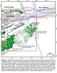
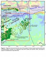
The present-day configuration of the Scotian margin began to take shape in the early Mesozoic during rifting of Pangea, between what is now Nova Scotia and Morocco in the central North Atlantic. At the onset of rifting (Middle Triassic), the Scotian margin was underlain by basement comprised of lower Paleozoic metasedimentary rocks of the Meguma Supergroup that were later intruded by mid-Paleozoic plutonic rocks (Pe-Piper and Jansa, 1999), and overlain locally by Carboniferous sedimentary basins (e.g. Pascucci et al., 1999; Waldron et al., 2010). An important Mesozoic strike-slip fault zone, referred to as the ‘southwest Grand Banks transform margin’ (Pe-Piper and Piper, 2004), cuts through the northern parts of Figures 2 and 3 (trending parallel to the “Collector Anomaly” in this area). It forms a westward continuation of the northwest trending Newfoundland Fracture Zone, and closely coincides with an important Mesozoic hinge zone where basement depth increases abruptly to the south. The trace of the hinge zone continues to the west where it forms the northern boundary of the Orpheus Graben, and continues onshore and into the Fundy Basin as the Cobequid-Chedabucto fault system (Wade and MacLean, 1990; MacLean and Wade, 1992; Jansa et al., 1993; Pe-Piper and Piper, 2004; Pe-Piper et al., 2007). On magnetic maps, this strike-slip zone closely follows the trend of the “Collector Anomaly” that separates rocks of the Avalon terrane to the north from rocks of the Meguma terrane to the south (Haworth and Lefort, 1979; Fig. 3). As such, the SW Grand Banks transform margin probably formed, in part, along a reactivated Paleozoic lineament (Keen et al., 1990), and was intermittently active through the Mesozoic and perhaps into the Tertiary (Pe-Piper and Piper, 2004). Early and mid-Cretaceous volcanism on the southern Grand Banks and near the Orpheus Graben, respectively, record periods of reactivation along parts of this terrane boundary (Wade and MacLean, 1990; Pe-Piper and Piper, 2004; Pe-Piper et al., 2007).
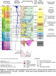
On the Scotian Shelf south of the transform margin, Triassic crustal extension produced a series of east-west to northeast-southwest trending grabens and half grabens (Wade and MacLean, 1990; CNSOPB, 2013). Non-marine fluvial-lacustrine-playa synrift sediments accumulated in these narrow rift-basins, but giving way both laterally (towards the rift axis) and up-section to widespread accumulations of salt during intermittent latest Triassic marine incursions (Wade and MacLean, 1990) (Fig. 4). Rifting on the Scotian margin lasted between 20 and 30 m.y. (Keen and Beaumont, 1990), with salt believed to have accumulated during rifting or near the end of rifting, potentially into the earliest postrift (Deptuck, 2011). Salt was thickest along the axes of these rift basins, thinning above or terminating along intervening basement highs like the Canso, Missisauga, and South Griffin ridges (Kendell, 2012; CNSOPB, 2013; Fig. 2). A second important hinge zone developed along the southern boundary of the Canso Ridge, with basement depth increasing to the south. The Huron Subbasin located seaward of this hinge zone and immediately landward of the South Griffin Ridge (OETR, 2011; CNSOPB, 2013), was a primary repository for Upper Triassic to Lower Jurassic salt (Argo Formation). Much of this salt was expelled onto the slope in response to Middle to Late Jurassic sediment loading coupled with an increase in margin tilt in response to thermal subsidence (Shimeld, 2004; Ings and Shimeld, 2006; Albertz et al. 2010).
The origin of basement rocks found seaward of the South Griffin Ridge is disputed. On the eastern Scotian Slope there is a weaker continuation of the East Coast Magnetic Anomaly (ECMA; Fig. 3), widely interpreted to mark the continent-ocean boundary further south (e.g. Klitgord and Schouten, 1986; Keen et al., 1990; Dehler, 2010; Labails et al., 2010). On the southwestern Scotian Slope this anomaly has been linked to the development of a volcanic margin with seaward dipping reflections (SDRs) found along the seaward edge of an autochthonous salt basin (Keen and Potter, 1995; Wu et al., 2006; Dehler, 2010, 2012; Deptuck, 2011; OETR, 2011). The weaker and more discontinuous eastern extension of the ECMA, however, has been variously interpreted as (a) a buried volcanic ridge (extending the volcanic margin all the way to the SW Newfoundland transform margin; e.g. OETR, 2011); (b) exhumed mantle emplaced after a rift jump (formed during mantle exposure and serpentinization; e.g., Sibuet et al, 2012), (c) thinned continental crust underlain by partially serpentinized mantle (e.g. Funck et al., 2004; Wu et al., 2006; Louden et al., 2012) or (d) extended continental crust overlain by thin volcanic layers emplaced during break-up (e.g. Dehler, 2012). The rugose basement immediately to the southeast of the ECMA along the eastern parts of the margin (described in more detail in a later section) has been variously interpreted as partially to heavily serpentinized mantle (Funck et al., 2004; Lau et al., 2010; Louden et al., 2012) or very thin slow spreading oceanic crust above partially serpentinized mantle (Louden et al., 2012), serpentinized mantle with minor volcanics on top (Sibuet et al., 2012), or oceanic crust (OETR, 2011).


