Potential Hydrocarbon-bearing Structures
Potential Hydrocarbon-bearing Structures
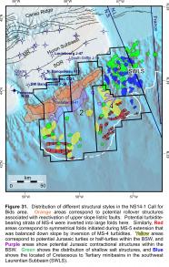
Each of the NS14-1 parcels contains a range of potential Cretaceous and Jurassic drilling targets. Figure 31 summarizes the distribution of potential traps and minibasins. Parcels 1 and 2 cover the proximal to distal reaches the BSW, which contains a range of potential hydrocarbon-bearing structures that developed during a complex period of salt tectonics. Numerous turtles and half turtles are recognized in Parcels 1, 2, and 4. Local shortening also appears to have produced several folds and local thrust sheets in the headward parts of the BSW. Overthrusting of over-rotated basins in roho systems also generated potential traps in the BSW.
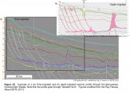
Reactivation of the Middle to latest Jurassic BSW in the mid-Cretaceous to Eocene inverted a Lower Cretaceous succession strongly believed to contain sandy turbidites (Missisauga fan complex). Several salt-cored buckle folds containing MS-4 strata are present on the lower slope, particularly in the seaward parts of Parcels 1 and 4 (Figs. 31). Deep water depths here may prohibit testing some of these structures. The most promising drilling targets correspond to a series of large, long-wavelength folds found on the upper to middle slope above the headward parts of the BSW in Parcels 1 and 2. These folds, termed the “stonehouse trend”, are 15 to 20 km wide and 20 to 40 km long, with potential four-way dip closure areas in excess of 200 km2 (based on regional depth structure map presented on Panel 5-3-8b of OETR, 2011). Tantallon M-41, which encountered a ~10 m interval of gas charged sands in the lower parts of the Missisauga fan complex (Goodway et al., 2008), is located along the stonehouse trend, but appears to have been positioned in a saddle region between two large rollover structures on the K130 depth structure map (OETR, 2011). Amplitude extractions from a modern 3D seismic volume along strike from Tantallon M-41 (from the Stonehouse 3D survey) reveal a number of geobodies that likely correspond to porous sands associated with amalgamated turbidite channels (Goodway et al., 2008). Such data were not available when the Tantallon well was drilled in 1986. A comparison of time-migrated and depth-migrated seismic profiles illustrates the importance of modern depth data for defining structural closure along this trend (e.g. Fig. 32). Likewise, modern processing is needed to better define potential turbidite reservoirs within these structures. The timing of folds along the stonehouse trend is ideal because it immediately post-dates the period of widespread turbidite deposition on the slope associated with the Missisauga fan complex.
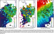
Parcel 3 is located above southwest Laurentian Subbasin (SWLS). Salt-related structures in Parcel 3 are complex, with as many as three tiers of allochthonous salt that create a wide variety of potential trap configurations, but also substantially degrade seismic imaging. The seaward half of Parcel 3 is located above the Southwest Laurentian Salt Canopy that was expelled from the SWLS. Time-structure maps above the deepest allochthonous salt surface provide an indication of the distribution of minibasins, parts of which were covered by one or more shallower tiers of more recently expelled salt (compare Figs. 33a and 33b). Numerous potential minibasin, salt flank, and sub-salt targets exist in Parcel 3. Further seaward, Parcel 4 is located in a complex region of loading and detachment above salt that was expelled from both the BSW and the SWLS. Structures include potential turtles and salt-cored folds, but the deep water depths here will pose additional exploration challenges.


