


Basement rocks are defined as all formations older than the mid-Devonian McAdams Lake Formation, and the top of basement is represented by the D360 seismic horizon, the deepest mapped surface in this study (Figure 2.2). Defining and correlating pre-Carboniferous basement terranes throughout the Maritimes Basin has been the focus of many previous studies, and while not the primary objective of this study, an understanding of the different terranes and their boundaries is necessary and aided the regional seismic interpretation.
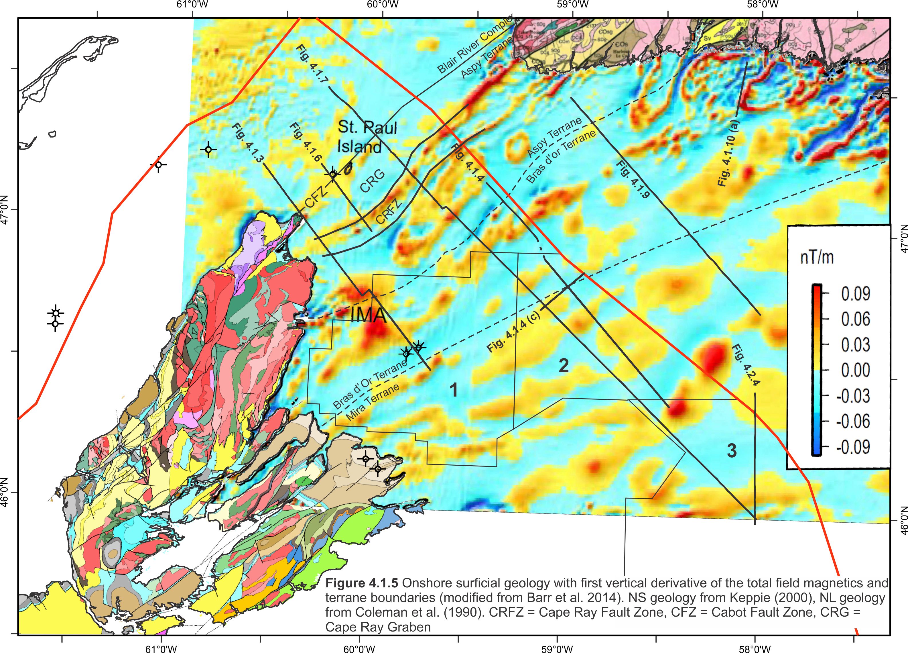
At least four pre-Carboniferous terranes are interpreted to be present across the study area (Williams, 1978; Hibbard et al., 2006; Barr et al. 2014, Waldron et al., 2015) (see Figures 4.1.2a, b, 4.1.3 , 4.1.4 and 4.1.5). The Precambrian Mira Terrane of southeast Cape Breton, and its equivalent, the Avalon Terrane in Newfoundland, consist of volcanic, sedimentary and plutonic rocks (Bevier et al., 1992). Offshore, the top of the Mira Terrane is challenging to correlate on seismic profiles (D360 marker), but there are strong indications it was heavily faulted into a series of narrow southwest-northeast trending horsts and grabens that underpin the southern portions of the Sydney Basin. The top of Mira basement was carried below a series of higher amplitude faulted and locally folded reflections believed to correspond to an early period of fill within the Sydney Basin, but there is no distinct ‘top basement’ reflection here (Figure 4.1.4).
The offshore boundary between the Mira Terrane and the Bras d’Or Terrane to the west was defined by Barr et al. (2014) on the basis of potential fields data (Figure 4.1.5; see also their Figure 10) and coincides closely with the North Sydney Fault Zone (NSFZ) defined by Pascucci et al. (2000). Relative to the top basement surface mapped in this study (D360 marker; Figure 4.1.2b), the terrane boundary tracks along the southern border faults of a narrow inverted graben penetrated by the North Sydney wells (coincident with the “Boisdale Anticline” of Hacquebard, 1983), and skirts along the northern border faults of the westernmost grabens of the Mira Terrane (Figure 4.1.2b). The boundary coincides with a number of large-offset, basement faults that likely formed initially during the Acadian Orogeny, and were later reactivated to create accommodation space for mid-Devonian McAdams Lake Formation and earliest Mississipian Horton Group strata.
As defined by Raeside and Barr (1990), the Bras d’Or Terrane consists of pre-Middle Devonian gneisses, Proterozoic clastic-volcanoclastic-carbonates, late Proterozoic to Cambrian intrusives and Ordovician/Devonian intrusives. On offshore seismic lines, the number of faults progressively decreases towards the northwest, away from the Mira Terrane, where the basement marker forms a topographic high. Here, Bras d’Or basement has a “smooth” character and lacks any coherent internal reflectivity on seismic profiles. The interface between the Bras d’Or Terrane and the sedimentary section above it commonly produces a high-amplitude seismic reflection that is easily identified throughout this part of the Sydney Basin (and below which multiple peg-leg multiples commonly ring) (Figures 4.1.3 and 4.1.4). The D360 surface along this topographic high is generally no deeper than 1 sec (twt) and correlated with a high degree of confidence. The high-amplitude character of the D360 surface here is probably in response to the acoustic impedance contrast between the overlying sedimentary section and high-velocity basement rocks of the Bras d’Or Terrane (granites?), though no wells penetrate basement in the Sydney Basin.
The Aspy Terrane is composed of predominantly Ordovician- Silurian metavolcanic and metasedimentary rocks (Lin, 1993). Like the Bras d’Or Terrane, the D360 marker across the Aspy Terrane forms a high amplitude reflection mapped with a high degree of confidence except where it approaches the Cabot Fault zone (CFZ) along its western edge (where the marker deepens). The Aspy Terrane is bisected by a number of tightly spaced faults corresponding to the CRFZ defined by Langdon and Hall (1994). These probable strike-slip faults form a positive flower structure across most of the study area (Figures 4.1.3 and 4.1.7) with a slight negative expression near the St. Paul well (Figure 4.1.6).
The western boundary of the Aspy Terrane corresponds to the CFZ, a prominent strike-slip terrane boundary described in previous studies (Langdon and Hall, 1994; Pascucci et al., 2000) The offshore boundary between the Bras d’Or and Aspy terranes has been defined previously on the basis of potential fields data (Figure 4.1.5; e.g. Figure 10 of Barr et al. 2014) and coincides closely with the Eastern Highlands Shear Zone (EHSN) defined by Raeside and Barr (1990). Relative to the top basement surface mapped in this study (D360 marker; Figure 4.1.2b), the terrane boundary has no obvious structural expression, and instead generally bisects the broad basement high that forms the offshore extension of the Cape Breton Highlands. Similarly, aside from Figure 4.1.3, most seismic profiles show little cross-sectional expression of this terrane boundary.
The reader should note that in previous studies (e.g. Langdon and Hall, 1994; Pascucci et al., 2000), the high amplitude response of the D360 marker across the Bras d’Or and Aspy Terranes was instead interpreted as a regionally extensive Namurian (i.e. “Mississippian-Pennsylvanian”) unconformity. However, a well tie with new biostratigraphic data from Weston et al. (2017) and, more importantly, differentiating seismic multiples from real seismic events (assisted in particular by the use of high resolution, shallow penetrating seismic data, e.g. Figure 4.1.6) has led to a much different interpretation in this study. Here, we carry the Namurian unconformity shallower, above the D360 marker. North of the North Sydney P-05 well, the seismic event corresponding to the Namurian unconformity shallows and crops out at the seafloor near the CRFZ. The marker is located above what appear to be Visean (Windsor Group) salt diapirs identified on a number of seismic profiles along the western boundary of the Aspy Terrane. Additional salt diapirs are also recognized in the Cape Ray Graben (CRG)(CRG; Langdon and Hall, 1994) where the basement marker deepens (Figure 4.1.3, 4.1.6 and 4.1.7). Likewise, onshore exposures of Windsor Group strata in Aspy Bay support the presence of Windsor Group strata within the CRG. A Namurian aged unconformity cannot underlie these diapirs as previous interpretations have done, unless these diapirs correspond to post-Namurian evaporites, which to date have not been recognized in the basin.
The fourth terrane within this study is the Blair River Complex, which is found north of the CFZ. This region was not extensively mapped as it extends into the Magdalen Subbasin and is outside of the study area, but basement deepens dramatically and there is an abundance of salt diapirs that inhibit imaging of the top basement surface.
Gravity and Magnetic Expression of the Bras d’Or and Aspy Terranes
As described above, this study carries the top basement D360 marker much shallower across the Aspy and Bras d’Or Terranes than interpreted in previous studies. It was also carried shallower than the depth Barr et al. (2014) used in their potential field modeling. One explanation for the preference for carrying basement deeper across these terranes in previous studies is the pronounced, east-west, oval-shaped gravity low across this region (Figure 4.1.8). A shallow basement pick would not be favoured across a region that forms a gravity low, because in many cases gravity lows correspond to regions with thick, less dense sedimentary cover.
Our interpretation suggests basement is shallow here and veneered by a relatively thin sedimentary cover that is counter to the gravity data. However, the onshore gravity expression of the Exploits Zone of central Newfoundland (equivalent to the Aspy Terrane) is also low, and corresponds to low-density granitic plutons (Figure 4.1.10b). Similarly, shallow penetrating high-resolution seismic profiles across a gravity low immediately offshore from these gravity lows reveal thinning of coherent Carboniferous strata above a strong basement marker interpreted as a granitic pluton (Figure 4.1.10a). The D360 marker was tied to this line from nearby deeper industry seismic lines, and is overlain by coherent reflections of the Pennsylvannian Sydney Mines and South Bar formations. The basement rocks beneath these formations subcrop at the seafloor where they have a chaotic, high-energy reflection character interpreted to represent a granitic body. This potential pluton is directly offshore from known onshore granites within the Exploits subzone of Newfoundland and also corresponds to a gravity low. Furthermore, low-density granites that produce gravity lows are known to exist elsewhere in the region. The South Mountain Batholith onshore Nova Scotia (Benn et al., 1999) and New Brunswick’s Saint George Batholith (King and Barr, 2003) are two examples of significant gravity lows produced by low-density Devonian granitic plutons. As such, the offshore gravity low across the Aspy and Bras d’Or terranes could reflect the presence of similar low-density plutons beneath a thin veneer of Carboniferous strata. Seismic lines across this feature consistently show Carboniferous sediments onlapping and thinning onto the D360 seismic marker as it shallows northward toward the CRFZ (Figures 4.1.3, 4.1.4, 4.1.7 and 4.1.9), consistent with Carboniferous strata that onlap a pre-existing (mid-Devonian or older) sequence of rocks.
Evidence for intrusive granites are also noted on the magnetic data, where circular, magnetic high “halos” are present throughout the Aspy Terrane (Figure 4.1.5). Barr et al. (2014) suggested that these “halos in the Exploits (Aspy) subzone are probably caused by Silurian-Devonian plutons like those in the Burgeo Intrusive Suite”. Therefore, we interpret the gravity low feature represents pre-Carboniferous intrusives, with most of the overlying sedimentary section mapped as thinning onto it.