


Location & Coordinates
CORNER POINTS PARCEL 1
| Parcel 1 Outline | |
| Decimal Latitude | Decimal Longitude |
43.66667
|
-60.27500
|
43.70000
|
-60.27500
|
43.70000
|
-60.17500
|
43.76667
|
-60.17500
|
43.76667
|
-60.25000
|
43.75000
|
-60.25000
|
43.75000
|
-60.27500
|
43.86667
|
-60.27500
|
43.86667
|
-60.25000
|
43.85000
|
-60.25000
|
43.85000
|
-60.17500
|
43.86667
|
-60.17500
|
43.86667
|
-60.15000
|
43.91667
|
-60.15000
|
43.91667
|
-59.75000
|
43.66667
|
-59.75000
|
43.66667
|
-59.77500
|
43.70000
|
-59.77500
|
43.70000
|
-59.80000
|
43.71667
|
-59.80000
|
43.71667
|
-59.90000
|
43.70000
|
-59.90000
|
43.70000
|
-59.95000
|
43.68333
|
-59.95000
|
43.68333
|
-59.97500
|
43.66667
|
-59.97500
|
43.66667
|
-60.27500
|
Parcel 1 - gaps within the Parcel
|
|
Gap 1 - South Sable SDA
|
|
Decimal Latitude
|
Decimal Longitude
|
43.86667
|
-59.87500
|
43.90000
|
-59.87500
|
43.90000
|
-59.82500
|
43.86667
|
-59.82500
|
43.86667
|
-59.87500
|
Parcel 1 - gaps within the Parcel
|
|
Gap 2 - Intrepid SDA
|
|
Decimal Latitude
|
Decimal Longitude
|
43.80000
|
-60.00000
|
43.83333
|
-60.00000
|
43.83333
|
-59.97500
|
43.86667
|
-59.97500
|
43.86667
|
-59.95000
|
43.88333
|
-59.95000
|
43.88333
|
-59.90000
|
43.80000
|
-59.90000
|
43.80000
|
-60.00000
|
LAND PARCEL 1 – All petroleum substances in all geological formations
| Grid* | Hectares | Sections |
| 44-00-59-45 | 14,136 | 1-5, 11-15, 21-25, 31-32, 35, 41-42, 45, 51-55, 64-65, 74-75, 83-85, 91-95 |
| 44-00-60-00 | 13,020 | 1-5, 11-15, 21-25, 31-35, 41-45, 51-55, 61-62, 71, 81, 91 |
| 44-00-60-15 | 744 | 1-2 |
| 43-50-59-45 | 27,197 | 1-10, 13-20, 24-30, 34-40, 44-50, 54-60, 63-68, 73-78, 82-88, 91-98 |
| 43-50-60-00 | 32,784 | 1-72, 77-82, 87-92, 97-100 |
| 43-50-60-15 | 2,607 | 1-2, 6-10 |
| Total Hectares | (Approximate) | 90,488 |
*NAD 1927
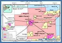
Parcels Map