


print this page
Exploration History
Parcel 2
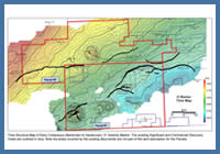
FIGURE: 10
Time Structure Map of Early Cretaceous (Barremian to Hauterivian) ‘O’ Seismic Marker. The existing Significant and Commercial Discovery Areas are outlined in blue. Note the areas covered by the existing discoveries are not part of the land description for the Parcels.
Time Structure Map of Early Cretaceous (Barremian to Hauterivian) ‘O’ Seismic Marker. The existing Significant and Commercial Discovery Areas are outlined in blue. Note the areas covered by the existing discoveries are not part of the land description for the Parcels.
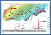
Since the 1960s, all or part of Parcel #2 has been licenced repeatedly by industry. During this time many seismic surveys were acquired and a considerable number of wells were drilled. The most recent Exploration Licences (EL) over the parcel were acquired by ExxonMobil Canada in the late 1990s and included: EL 2356, EL 2369, EL 2370 and EL 2371. During the time ExxonMobil held these licences they drilled two wells on what is currently Parcel #2 (Emma N-03 & Adamant N-97). Neither of these wells encountered commercial volumes of hydrocarbons, therefore the licences were allowed to expire. Two regional maps of the early Cretaceous ‘O’ Marker and a Lower Missisauga seismic marker display a number of structures in the area of the Parcels. Since exploration began offshore Nova Scotia many of these structures have been drilled and a considerable number were declared either Significant or Commercial Discoveries, figures 10 and 20.
Figure 20
Time Structure Map of Early Cretaceous (Hauterivian to Valanginian) Lower Missisauga Seismic Marker. The existing Significant and Commercial Discovery Areas are outlined in blue. Note the areas covered by the existing discoveries are not part of the land description for the Parcels.
Time Structure Map of Early Cretaceous (Hauterivian to Valanginian) Lower Missisauga Seismic Marker. The existing Significant and Commercial Discovery Areas are outlined in blue. Note the areas covered by the existing discoveries are not part of the land description for the Parcels.
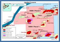
Parcel #2 is located approximately 160 km offshore Nova Scotia, figure 11. The southern portion of the parcel surrounds Sable Island and water depths on the block are up to 50 metres. Parcel #2 is adjacent to five significant discoveries (West Sable, West Olympia, Olympia, West Venture C-62 and West Venture N-91) and two producing gas fields (Thebaud and South Venture). The above discoveries were made between 1971-1985. The Thebaud and South Venture gas fields are part of ExxonMobil’s Sable Offshore Energy Project and have been on production since 2000 and 2004, respectively. These fields are producing from early Cretaceous Missisauga and upper Jurassic Mic Mac fluvial deltaic sandstone reservoirs. To the end of September 2009, Thebaud and South Venture have produced 11.7 E9M3 (414 Bcf) and 5.8 E9M3 (204 Bcf) of gas, respectively.
The following five wells have been drilled on Parcel #2: Sable Island C-67, Migrant N-20, Cohasset L-97, Emma N-03 and Adamant N-97. Each well is described below.
Figure 11
Prospect Map
Prospect Map
Sable Island C-67 was spudded by Mobil Oil in June 1967. It was the first well drilled offshore Nova Scotia and was spudded, on land, in the middle of Sable Island. The well was drilled to determine the hydrocarbon potential of the sediments beneath Sable Island and to evaluate the flank of a deep seated structure. The well reached a total depth of 4604 m in the early Cretaceous lower Missisauga Formation. In the lower Mississauga, from approximately 4000 m to TD, questionable oil staining and minor mud-gas shows were encountered in a number of poor quality sands. Four DSTs were attempted three of which were mechanically successful. Of the mechanically successful DSTs, two recovered salt water and one (DST #4: 4447.6-4604.3 m) recovered minor gas and oil. There was no gas to surface during DST #4 but a small amount of gas and 50 cc of 39° API oil was recovered from the bottom hole sampler. The hydrocarbons recovered in DST #4 appear to be coming from poor quality sand(s) near the base of the well.
Migrant N-20 is located 12 km west of Sable Island and was spudded by Mobil et al in July 1977 in 14 m of water. The well was drilled to test for hydrocarbons in early Cretaceous Missisauga and late Jurassic Mic Mac sands trapped within a rollover anticline. The well reached a total depth of 4669 m in the Mic Mac Formation. Eight DSTs were attempted in three upper Mic Mac sands. Three of the DSTs were misruns, four had no recovery and one (DST #2: 4333.0-4361.7 m) flowed gas at a rate of 10 MMscf/d. Depletion was noted during DST #2 suggesting the zone may have limited areal extent or the presence of a boundary, such as a fault, near the wellbore. The two other Mic Mac sands that were tested appear gas bearing on logs but were unable to flow due to low effective porosities (<7%).
Cohasset L-97 is located 28 km west of Sable Island and was spudded by Mobil et al in July 1978 in 22 m of water. The well was drilled to test for hydrocarbons in Cretaceous sands draped over a deep-seated structural high. The well drilled through the entire Abenaki Formation and reached a total depth of 4872 m in the early to mid Jurassic Mohican Formation. Two zones within the reefal Baccaro member of the Abenaki Formation were flow tested but only DST #2B (3600.0-3620.4 m) recovered hydrocarbons. This interval was initially tested (DST #2A) and did not flow and was then acidized and slugged gas (1-9 m flare) and water (maximum salinity 70,000 ppm). The DST results indicate the tested interval is a low permeability gas zone with a nearby gas water contact.
Emma N-03 is located 13 km north of Sable Island and was spudded by Mobil et al in August 2000 in 51 m of water. The well was drilled to test for hydrocarbons in early Cretaceous Missisauga and late Jurassic Mic Mac Formation stacked fluvial deltaic sands trapped in a rollover anticline. The well reached a total depth of 4600 m in the upper Jurassic Mic Mac Formation. The Missisauga Formation penetrated at Emma is a high net to gross interval with very good to excellent reservoir development. The abundance of sand in this interval causes the north bounding fault to leak thereby limiting any hydrocarbon accumulations to simple closure. The upper portion of the Mic Mac also has good to very good reservoir development with a net to gross similar to the overlying Missisauga Formation. Although some simple closure is present at these elevations the presence of crestal faults provides a leak point resulting in wet sands. While simple closure is present deeper in the well, there is little to no reservoir development in this interval. In the upper Mic Mac Formation a thin sand with two metres of questionable gas pay was encountered. No significant hydrocarbon bearing zones were encountered in the well.
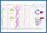
Figure 21
Adamant N-97 –Sands 2 & 3 (Lower Missisauga) Petrophysical Results Plot. Note each sand has six metres of net gas pay over water.
Adamant N-97 –Sands 2 & 3 (Lower Missisauga) Petrophysical Results Plot. Note each sand has six metres of net gas pay over water.
Adamant N-97 is located 8 km west of Sable Island and was spudded by Mobil et al in November 2000 in 17 m of water. The well was drilled to test for hydrocarbons in early Cretaceous Missisauga and late Jurassic Mic Mac Formation stacked fluvial deltaic sands trapped in a rollover anticline. The well reached a total depth of 4708 m in the upper Jurassic Mic Mac Formation. A number of gas bearing sands with fair to good reservoir quality were encountered in the lower Missisauga and upper Mic Mac formations. Two of these sands (Sands 2 & 3) are shown in figure 21. Sands 2 and 3 have log defined gas-water contacts and column heights of approximately 15 m, which is consistent with the amount of simple closure, as a result these zones are interpreted to leak at the north bounding fault. Thin gas pay was encountered in the upper Mic Mac Formation. This thin gas column is consistent with the minimal simple closure at this elevation and again suggests the leak point is at the bounding fault. A total of 16 m of net gas pay was identified in Adamant N-97, however the field’s hydrocarbon reserves were deemed too small to be commercially viable.
The well results for Parcel #2 are summarized below.
Table 1 – Well Results Summary (Parcel #2)
Well |
Year Spudded |
Total Depth (m) |
Target Fm. (Age) |
Play / Trap |
Sable Island C-67 |
1967 |
4604 |
Logan Canyon & Missisauga (Cretaceous) |
Stratigraphic test & flank of deep seated structure |
Migrant N-20 |
1977 |
4669 |
Missisauga (early Cretaceous) & Mic Mac (late Jurassic) |
Rollover anticline |
Cohasset L-97¹ |
1978 |
4872 |
Missisauga (early Cretaceous) |
Cretaceous sands draped over a deep-seated structural high |
Emma N-03 |
2000 |
4600 |
Missisauga (early Cretaceous) & Mic Mac (late Jurassic) |
Rollover anticline |
Adamant N-97 |
2000 |
4708 |
Missisauga (early Cretaceous) & Mic Mac (late Jurassic) |
Rollover anticline |
¹ For additional details on Cohasset L-97 refer to the CNSOPB publication: The Upper Jurassic Abenaki Formation Offshore Nova Scotia: A Seismic and Geologic Perspective (CNSOPB, June 2005, pgs.17-19, 100-101 and 105).
A number of seismic surveys have been acquired over portions of Parcel #2 since the 1960s. Interpretation reports are available for many of them, with the following table listing the available programs.