


print this page
Exploration History
Parcel 1
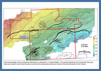
FIGURE: 10
Time Structure Map of Early Cretaceous (Barremian to Hauterivian) ‘O’ Seismic Marker. The existing Significant and Commercial Discovery Areas are outlined in blue. Note the areas covered by the existing discoveries are not part of the land description for the Parcels.
Time Structure Map of Early Cretaceous (Barremian to Hauterivian) ‘O’ Seismic Marker. The existing Significant and Commercial Discovery Areas are outlined in blue. Note the areas covered by the existing discoveries are not part of the land description for the Parcels.
Since the 1960s, all or part of Parcel #1 has been licenced repeatedly by industry. During this time many seismic surveys were acquired and a number of wells were drilled. The most recent Exploration Licences (EL) over the parcel were acquired by ExxonMobil Canada in the late 1990s and included: EL 2356, EL 2371, EL 2372 and EL 2373. During the time ExxonMobil held these licences they did not drill any wells on what is currently Parcel #1 and the ELs eventually expired. A regional map of the early Cretaceous ‘O’ Marker displays a number of the structures in the area. Since exploration began offshore Nova Scotia many of these structures have been drilled and a considerable number were declared either Significant or Commercial Discoveries, figure 10.
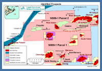
Parcel #1 is located approximately 175 km offshore Nova Scotia, figure 11. The parcel is located approximately 1 km due south of Sable Island in water depths ranging from 50-100 metres. Parcel #1 is directly adjacent to five significant gas discoveries (Onondaga, Intrepid, South Sable, Glenelg & Chebucto) and two producing gas fields (Thebaud & North Triumph). The above discoveries were made between 1969-1988. The Thebaud and North Triumph gas fields are part of ExxonMobil’s Sable Offshore Energy Project and have been on production since 1999 and 2000, respectively. These fields are producing from early Cretaceous Missisauga and upper Jurassic Mic Mac fluvial deltaic sandstone reservoirs. To the end of September 2009, Thebaud and North Triumph have produced 11.7 E9M3 (414 Bcf) and 6.6 E9M3 (233 Bcf) of gas, respectively.
FIGURE: 11
Prospect Map
Prospect Map
The following wells have been drilled on Parcel #1: Marmora C-34 and Marmora P-35. Each well is described below.
Marmora C-34 is located 23 km south of Sable Island and was spudded by Shell Canada in January 1972 in 58 m of water, figure 11. The well was drilled to test for hydrocarbons in early Cretaceous Missisauga Formation stacked deltaic sands trapped in a rollover anticline. The well reached a total depth of 4038 m in the lower Missisauga Formation. No DSTs were conducted but well logs and wireline tester samples confirmed the presence of a high quality gas bearing reservoir sand at the top of the upper Missisauga Formation (Sand 1). With the exception of Sand 1, no other significant hydrocarbon bearing zones were encountered. For detailed information on the Marmora C-34 well refer to the Parcel #1 Exploration Potential section of this document.
Marmora P-35 is located 20 km south of Sable Island and was spudded by Shell et al in March 1973 in 53 m of water, figure 11. Marmora P-35 is located approximately 3 km north of Marmora C-34 and was drilled to test for hydrocarbons in early Cretaceous Missisauga Formation stacked deltaic sands believed to be trapped in a rollover anticline. The well reached a total depth of 4093 m in the lower Missisauga. The Missisauga Formation penetrated in Marmora P-35 is a high net to gross interval with many good quality reservoir sands, however no significant hydrocarbon bearing zones were encountered. P-35 was positioned using 1970s vintage 2D seismic data, recent mapping using modern 3D data indicates there is no simple or fault dependent closure at the well.
The well results for Parcel #1 are summarized below.
Table 1 – Well Results Summary (Parcel #1)
Well |
Year Spudded |
Total Depth (m) |
Target Fm. (Age) |
Play / Trap |
Marmora C-34 |
1972 |
4038 |
Missisauga (early Cretaceous) |
Rollover anticline |
Marmora P-35 |
1973 |
4093 |
Missisauga (early Cretaceous) |
Rollover anticline |
A number of seismic surveys have been acquired over portions of Parcel #1 since the 1960s. Interpretation reports are available for many of them, with the following table listing the available programs.