


print this page
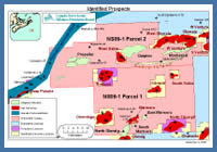
Parcel 2 Exploration Potential
Figure 11
Prospect Map
Prospect Map
The CNSOPB has identified a number of undrilled prospects with considerable hydrocarbon potential on Parcel #2. It should be noted that other prospects are likely present on the parcel which further seismic mapping may uncover. These prospects may include plays such as subtle drapes over basement highs or stratigraphic traps. The prospects identified by the CNSOPB are discussed below.
Dolphin
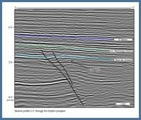
Figure 22
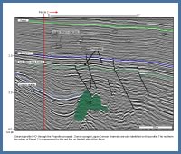
Seismic profile C-C’ through the Dolphin prospect.
Seismic profile C-C’ through the Dolphin prospect.
The Dolphin prospect is located approximately five kilometers north of Sable Island, figure 11. The structure is a fault bounded rollover anticline, figure 22. The trap is defined by dip closure to the east and southeast, fault dependent closure to the north and south and a stratigraphic pinch-out to the west against the West Sable salt diapir, figure 23. The interval under closure extends from the early Cretaceous lower Missisauga to the mid to late Jurassic Mic Mac Formation. Within this target interval the reservoirs are interpreted to be stacked fluvial deltaic sands similar to those encountered in nearby wells, figure 24.
Propeller
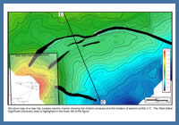
Figure 23
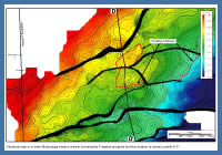
Structure map of a near top Jurassic seismic marker showing the Dolphin prospect and the location of seismic profile C-C’. The West Sable Significant Discovery area is highlighted in the lower left of the figure.
Structure map of a near top Jurassic seismic marker showing the Dolphin prospect and the location of seismic profile C-C’. The West Sable Significant Discovery area is highlighted in the lower left of the figure.
The Propeller structure is a group of three individual prospects separated by faults, and is located 18 km west of Sable Island, figure 11. The Propeller prospects are a group of fault bounded rollover anticlines formed by movement of the underlying salt caused by sediment loading, figure 25. The traps are a combination of simple and fault dependent closures that extend from the early Cretaceous lower Missisauga to the mid to late Jurassic Mic Mac Formation, figure 26. Within this target interval the reservoirs are interpreted to be stacked fluvial deltaic sands, figure 27.
Manhasset
The Manhasset structure contains a group of elongate prospects separated by faults and is located due east of Dolphin and five kilometres north of Sable Island, figure 11. The Manhasset prospects are a group of fault bounded rollover anticlines. The traps are primarily fault dependent closures, however minor simple closure is also present.The interval under closure extends from the early Cretaceous lower Missisauga to the mid to late Jurassic Mic Mac Formation. Within this target interval the reservoirs are interpreted to be stacked fluvial deltaic sands similar to those encountered in nearby wells, figure 27.
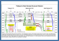
Figure 24
Thebaud to West Olympia Structural Cross-Section. The stratigraphic position of the Dolphin target interval is shown. Note Lower Missisauga and Mic Mac Formation gas sands are shown in red font. The Thebaud gas field is a Commercial Discovery and is currently producing as part of the Sable Gas Project. Sable Island E-48 (West Sable Field) and West Olympia O-51 (West Olympia Field) are both Significant Discoveries. Note this xsection crosses Parcel #2 from southwest to northeast.
Thebaud to West Olympia Structural Cross-Section. The stratigraphic position of the Dolphin target interval is shown. Note Lower Missisauga and Mic Mac Formation gas sands are shown in red font. The Thebaud gas field is a Commercial Discovery and is currently producing as part of the Sable Gas Project. Sable Island E-48 (West Sable Field) and West Olympia O-51 (West Olympia Field) are both Significant Discoveries. Note this xsection crosses Parcel #2 from southwest to northeast.
Logan Canyon Fluvial Channel Belts
Numerous fluvial channel systems of Albian to Aptian age, have been identified on Parcel #2 in the lower Logan Canyon Formation, figure 25. These channel systems are widespread and can be mapped over the entire parcel. The size of these systems varies, however a number of channels with widths over a kilometre have been mapped and many are laterally continuous for 10’s of kilometres. Any sands deposited in these channels are likely encased in marine shales creating possible stratigraphic traps. These fluvial channel belts have potential as a stratigraphic play within the Logan Canyon Formation.
Abenaki Carbonate Bank
The Jurassic age Abenaki carbonate bank crosses the western edge of Parcel #2, approximately 26 km west of Sable Island, figure 11. There is hydrocarbon potential in the Baccaro Member of the Abenaki Formation for reef margin leached limestone and vuggy dolostone reservoirs, similar to those encountered in the Deep Panuke gas field 20 km to the southwest. Other exploration opportunities associated with the Abenaki Formation include, but are not limited to, the following: oolitic shoals, patch reefs, foreslope deposits and bypassed sands deposited in front of the carbonate bank.
For all the above prospects, gas prone shales of the mid Jurassic to early Cretaceous Verrill Canyon Formation are the interpreted source rocks. The gas generated from these intervals is believed to have migrated along fault planes until it was trapped in the above structures. The number of significant and commercial discoveries in the Sable Subbasin, sourced from Verrill Canyon shales, clearly demonstrates the effectiveness of these source rocks.
Figure 25
Seismic profile D-D’ through the Propeller prospect. Some younger Logan Canyon channels are also identified on this profile. The northern boundary of Parcel 2 is represented by the red line on the left side of the figure.
Seismic profile D-D’ through the Propeller prospect. Some younger Logan Canyon channels are also identified on this profile. The northern boundary of Parcel 2 is represented by the red line on the left side of the figure.
Figure 26
Structure map of a lower Missisauga seismic marker showing the Propeller prospect and the location of seismic profile D-D’.
Structure map of a lower Missisauga seismic marker showing the Propeller prospect and the location of seismic profile D-D’.
Figure 27
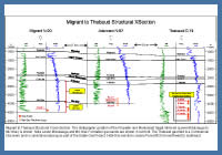
Migrant to Thebaud Structural Cross-Section. The stratigraphic position of the Propeller and Manhasset target intervals (Lower Missisauga to Mic Mac) is shown. Note Lower Missisauga and Mic Mac Formation gas sands are shown in red font. The Thebaud gas field is a Commercial Discovery and is currently producing as part of the Sable Gas Project. Note this xsection crosses Parcel #2 from northwest to southeast.
Migrant to Thebaud Structural Cross-Section. The stratigraphic position of the Propeller and Manhasset target intervals (Lower Missisauga to Mic Mac) is shown. Note Lower Missisauga and Mic Mac Formation gas sands are shown in red font. The Thebaud gas field is a Commercial Discovery and is currently producing as part of the Sable Gas Project. Note this xsection crosses Parcel #2 from northwest to southeast.