


Regional Geoscience Parcel 2 Figures
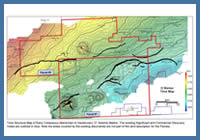
Figure 10
Time Structure Map of Early Cretaceous (Barremian to Hauterivian) ‘O’ Seismic Marker. The existing Significant and Commercial Discovery Areas are outlined in blue. Note the areas covered by the existing discoveries are not part of the land description for the Parcels.
Time Structure Map of Early Cretaceous (Barremian to Hauterivian) ‘O’ Seismic Marker. The existing Significant and Commercial Discovery Areas are outlined in blue. Note the areas covered by the existing discoveries are not part of the land description for the Parcels.
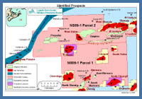
Figure 11
Prospect Map
Prospect Map
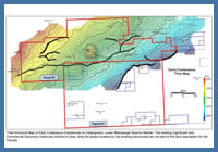
Figure 20
Time Structure Map of Early Cretaceous (Hauterivian to Valanginian) Lower Missisauga Seismic Marker. The existing Significant and Commercial Discovery Areas are outlined in blue. Note the areas covered by the existing discoveries are not part of the land description for the Parcels.
Time Structure Map of Early Cretaceous (Hauterivian to Valanginian) Lower Missisauga Seismic Marker. The existing Significant and Commercial Discovery Areas are outlined in blue. Note the areas covered by the existing discoveries are not part of the land description for the Parcels.
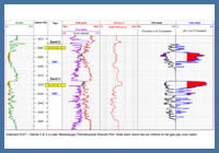
Figure 21
Adamant N-97 –Sands 2 & 3 (Lower Missisauga) Petrophysical Results Plot. Note each sand has six metres of net gas pay over water.
Adamant N-97 –Sands 2 & 3 (Lower Missisauga) Petrophysical Results Plot. Note each sand has six metres of net gas pay over water.
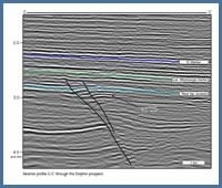
Figure 22
Seismic profile C-C’ through the Dolphin prospect.
Seismic profile C-C’ through the Dolphin prospect.
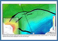
Figure 23
Structure map of a near top Jurassic seismic marker showing the Dolphin prospect and the location of seismic profile C-C’. The West Sable Significant Discovery area is highlighted in the lower left of the figure.
Structure map of a near top Jurassic seismic marker showing the Dolphin prospect and the location of seismic profile C-C’. The West Sable Significant Discovery area is highlighted in the lower left of the figure.
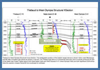
Figure 24
Thebaud to West Olympia Structural Cross-Section. The stratigraphic position of the Dolphin target interval is shown. Note Lower Missisauga and Mic Mac Formation gas sands are shown in red font. The Thebaud gas field is a Commercial Discovery and is currently producing as part of the Sable Gas Project. Sable Island E-48 (West Sable Field) and West Olympia O-51 (West Olympia Field) are both Significant Discoveries. Note this xsection crosses Parcel #2 from southwest to northeast.
Thebaud to West Olympia Structural Cross-Section. The stratigraphic position of the Dolphin target interval is shown. Note Lower Missisauga and Mic Mac Formation gas sands are shown in red font. The Thebaud gas field is a Commercial Discovery and is currently producing as part of the Sable Gas Project. Sable Island E-48 (West Sable Field) and West Olympia O-51 (West Olympia Field) are both Significant Discoveries. Note this xsection crosses Parcel #2 from southwest to northeast.
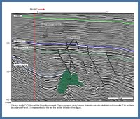
Figure 25
Seismic profile D-D’ through the Propeller prospect. Some younger Logan Canyon channels are also identified on this profile. The northern boundary of Parcel 2 is represented by the red line on the left side of the figure.
Seismic profile D-D’ through the Propeller prospect. Some younger Logan Canyon channels are also identified on this profile. The northern boundary of Parcel 2 is represented by the red line on the left side of the figure.
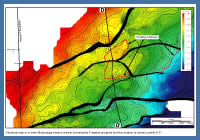
Figure 26
Structure map of a lower Missisauga seismic marker showing the Propeller prospect and the location of seismic profile D-D’.
Structure map of a lower Missisauga seismic marker showing the Propeller prospect and the location of seismic profile D-D’.
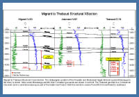
Figure 27
Migrant to Thebaud Structural Cross-Section. The stratigraphic position of the Propeller and Manhasset target intervals (Lower Missisauga to Mic Mac) is shown. Note Lower Missisauga and Mic Mac Formation gas sands are shown in red font. The Thebaud gas field is a Commercial Discovery and is currently producing as part of the Sable Gas Project. Note this xsection crosses Parcel #2 from northwest to southeast.
Migrant to Thebaud Structural Cross-Section. The stratigraphic position of the Propeller and Manhasset target intervals (Lower Missisauga to Mic Mac) is shown. Note Lower Missisauga and Mic Mac Formation gas sands are shown in red font. The Thebaud gas field is a Commercial Discovery and is currently producing as part of the Sable Gas Project. Note this xsection crosses Parcel #2 from northwest to southeast.