Exploration History
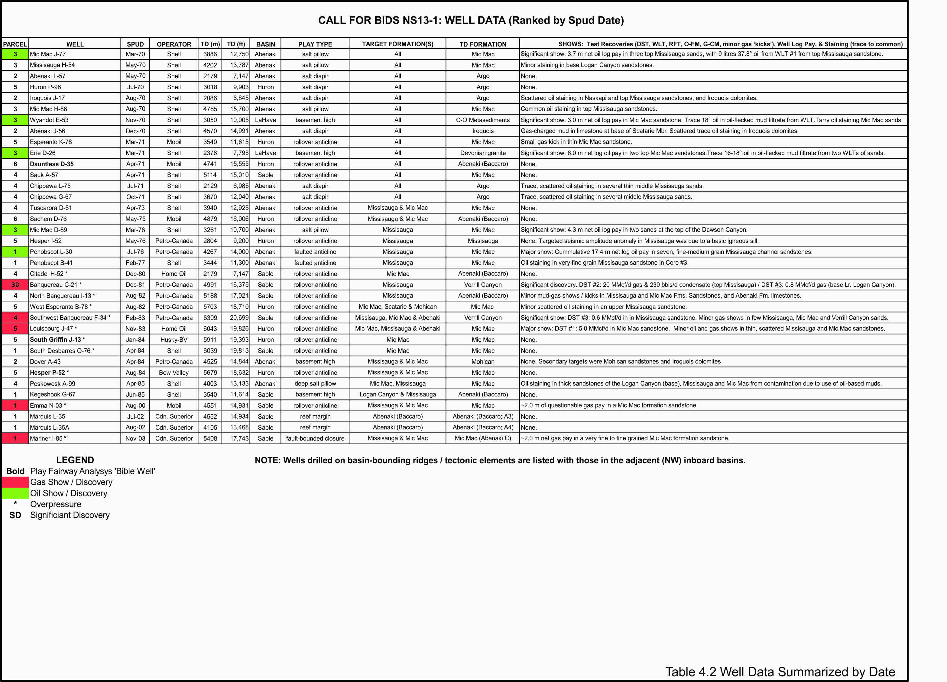
The Call for Bids NS13-1 area was one of the first regions to be explored on the Scotian Margin in the early 1970s, predominantly by Shell, and then by Mobil. Seismic, gravity and magnetic programs were ultimately followed by 20 wells, drilled up to 1976, targeting salt and basement related structures. These relatively shallow water plays were the first to be recognized and mapped on the margin. This early exploration effort established that a working, oil prone hydrocarbon system existed, but commercial success remained elusive.
The second phase of exploration followed in the early 1980s with 11 more wells drilled by 1985 that mainly tested rollover anticline closures, similar to the successful gas plays being pursued in the Sable Subbasin at the time. This effort resulted in major gas shows at Louisbourg J-47 and SW Banquereau F-34, with Banquereau C-21 being declared a Significant Discovery.
The third exploration phase began in 2000 with four wells drilled in the northwest margin of the Sable Subbasin testing rollover structures. Of the 35 wells drilled in the region, only one significant discovery licence was awarded at Banquereau C-21, though several significant oil and gas shows were observed along with minor staining.
Table 4.1 lists details on all wells, sorted by parcel, including hydrocarbon shows, TD formations, play types, basin, operators, and spud dates. Table 4.2 sorts the table by spud date and Table 4.3 by Subbasin. A list of all of the available seismic data, well data, and interpretation reports is available in the Data section.
Gravity-driven and salt-related structural closures in the Abenaki and Huron subbasins incorporate strata of the Late Jurassic Mic Mac and Early Cretaceous Missisauga formations, with potential reservoirs being thick fluvial and shallow marine sand successions. They are generally medium to coarse grain with good to excellent porosity that decreases with depth. Effective seals may be an issue in the upper successions.
Parcel 1
The most recent exploration drilling has occurred in Parcel 1, with three wells drilled between 2000 and 2004. Both clastics and carbonate plays were targeted. Parcel 1 is bordered to the east by seven significant gas discoveries and to the south by Exploration Licence 2427 that was awarded to Shell in 2013. There are six exploration wells on this parcel, one delineation well and one sidetrack.
In the eastern part of the Abenaki Subbasin, a significant oil discovery (36° API) was made by Shell in the Penobscot L-30 well (1976). Approximately 12.2 m oil pay was identified in several Early Cretaceous Missisauga formation channel sandstones. Recent evaluation by the CNSOPB has an estimated mean original oil in-place of 65 MMBbls. There are also two undrilled structures directly adjacent to the Penobscot discovery (North and Northeast Penobscot) with additional mean oil in-place of 82 MMBbls. This discovery is described in more detail in the Potential Traps and Reservoirs section.
The southern half of Parcel 1 covers the northwestern edge of the productive Sable Subbasin with 3 recent wells.
Approximately 13 km to the southeast from Penobscot L-30, Shell Canada Resources drilled the South Desbarres O-76 well in 69 m of water on a separate structure in 1984. This well reached a total depth of 6039 m and did not encounter any hydrocarbons.
The Emma N-03 well was drilled by Mobil in 2000. The upper part of the target zone was composed of a thick Early Cretaceous succession of Missisauga Formation fluvial and channel sands and thin intervening shales. The sands had very good porosity but were wet. A thick section of Late Jurassic Mic Mac Formation shoreface sands was encountered but exhibited poor porosity due to calcite cementation. Only two metres of questionable gas pay was found in a Mic Mac sandstone in the increasingly shale-dominated lower portion of the drilled interval. The thin, poor quality sealing shale combined with a small, leaking crestal fault on the structure was determined to be responsible for the limited pay.
Marquis L-35 and L-35A (sidetrack) was drilled by Canadian Superior in 2002, using only 2D seismic data, to test the Jurassic carbonate bank, although porosity was encountered in the Bacarro, no hydrocarbons were found.
Mariner I-85 was drilled by Canadian Superior in 2003, using only 2D seismic data, to test for fault bounded Cretaceous and Jurassic clastics. The sand development at this location was poor and only minor net gas pay was present in a very fine to fine grained Mic Mac Formation sandstone.
Kegeshook G-67 (1985) was drilled into tight Abenaki platform carbonates above the Missisauga Ridge.
Parcel 2
There were four wells drilled on Parcel 2. Abenaki L-57, Iroquois J-17 and Abenaki J-56 were drilled in 1970 on very poorly imaged salt diapirs. Minor oil staining was found in Iroquois J-17 and gas charged mud was recovered in Abenaki J-56. Dover A-43 (1984) was drilled on a fault dependant closure with no shows.
Parcel 3
On Parcel 3, all six wells drilled by Shell in the 1970s show oil indications of varying significance. Four of the six wells (Mic Mac J-77, Missisauga H-54, Mic Mac H-96, Mic Mac D-89) were drilled into salt related structures and two (Wyandot E-53, Erie D-26) were drilled on basement highs.
The Mic Mac J-77 well was drilled in 1970 and encountered minor oil pay in two sands at the top of the Early Cretaceous Missisauga formation:
- Zone 1: 1984.0 – 2045.7 m (62 m sand: 2.0 m oil pay, 32% avg. net pay porosity)
- Zone 2: 2054.0 – 2095.0 m (41 m sand: 1.0 m oil pay, 34% avg. net pay porosity)
In addition to 7.6 litres of 38.7o API oil recovered from a wireline test of Zone 1 at 1985.5 m, additional oil staining was documented in sandstones of the Dawson Canyon, Logan Canyon and Missisauga formations. Beyond the original analysis of this oil’s physical properties, its age, potential source and geochemical characteristics are unknown. The follow-up Mic Mac D-89 delineation well (1976) found 6.0 m net oil log pay in three stratigraphically higher sands at the top of the Late Cretaceous Dawson Canyon (Zones 1 & 2) and Logan Canyon formations (Zone 3):
- Zone 1 818.8 – 829.5m (~11 m sand: 2.0 m oil pay, 28% avg. net pay porosity)
- Zone 2: 871.5 – 875.5m (4 m sand: 1.0 m oil pay, 26% avg. net pay porosity)
- Zone 3: 899.0 – 918.0m (19 m sand: 3.0 m oil pay, 30% avg. net pay porosity)
Two early wells drilled by Shell in 1970 to test drape over basement structures both encountered thin oil pay. The Wyandot E-53 well penetrated porous reservoir sandstones in the Missisauga (very good to excellent porosity), Mic Mac (fair to very good), and Mohican formations (fair to good). It discovered a single 3.0 m of net oil pay within a thin Mic Mac Formation sandstone over which two wireline tests were run (Formation Interval Tester – FIT – with 20 litre sample chamber):
- Zone 1: 2367.2 – 2370.7m (3.5m sand: 3.0 m oil pay, 22% avg. net pay porosity)
- WLT #1: 2368.3 m (Rec. 9.5 litres of oil-flecked water / mud filtrate)
- WLT #2: 2368.0 m (Rec. 19 litres of oil flecked water / mud filtrate)
Erie D-26 was drilled near the Wyandot well testing a similar structure though closer to the basin-bounding hingeline fault. Missisauga and Mic Mac formations sandstones have good to excellent porosity, with fair to good porosity in the older Mohican Formation sandstones. Two thin oil zones were encountered in the Mic Mac Formation and evaluated with the FIT wireline tool:
- Zone 1: 1892.0 – 1918.8 m (26.8 m sand with 5.5 m oil pay over water & 28% avg. porosity). The OWC is observed in the sand. FIT #1 recovered 0.7 ft3 gas and 20 litres of oil-flecked water / mud filtrate.
- Zone 2: 1809.8 – 1812.3 m (2.5 m sand: 2.5 m oil pay, 27% avg. net pay porosity). FIT #2 recovered 20 litres of oil-flecked water / mud filtrate (16-18º API oil).
The Missisauga H-54 well (1970) had minor oil staining at the base of the Logan Canyon formation while Mic Mac H-86 had minor oil staining at the top of the Missisauga sandstones.
Parcel 4
Eight wells were drilled in Parcel 4. The three wells, Chippewa L-75 (1971) and Chippewa G-67 (1971), and Peskowesk A-99 (1985) were drilled on salt structures and all had scattered oil staining.
Peskowesk A-99 (1985) was drilled with oil based mud, so observed oil staining was questionable. Good to excellent porosity sands were encountered in the Missisauga Formation and poor to very good sands were encountered in the Mic Mac Formation.
The Tuscarora D-61 (1970) well encountered excellent porosity sands in the Mississauga and fair to very good porosity sands in the Jurassic, but encountered no hydrocarbons.
North Banquereau I-13 (1982) was drilled on a rollover anticline with minor mud gas shows and kicks in the Missisauga, Mic Mac, and Abenaki formations.
SW Banquereau F-34 (1983) was drilled on a rollover anticline with a significant gas show. DST #3 flowed 0.6 MMscf/d in a Missisauga sandstone. There were also minor gas shows in a few Missisauga, Mic Mac and Verrill Canyon sands.
Sauk A-57 (1971) and Citadel H-52 (1980) were drilled on rollover anticlines with no hydrocarbon indications.
The Banquereau C-21 Significant Discovery lies outside of the Call Parcels area but borders the southern boundary of Parcels 4 and 5. This rollover anticline was drilled in 83 m of water by Petro-Canada in 1982. Gas was discovered in shallow marine sands of the top Missisauga formation (DST #2: 20 MMcf/d gas & 230 bbls/d condensate), and the base of the Logan Canyon formation (Cree Member: DST #3: 0.8 MMcf/d gas). The reservoir sands demonstrated sustained flow on tests, and therefore the field was designated as a Significant Discovery.
Parcel 5
Seven wells were drilled on Parcel 5. Huron P-96 (1970) was the only well drilled on a salt structure and did not encounter any hydrocarbons. The remaining six wells were drilled on rollover structures.
Louisbourg J-47 (1983) and penetrated over 1800m of Jurassic section. The Mic Mac Formation at this location is carbonate rich with numerous thick, tight limestone intervals. The Mic Mac sands in J-47 generally have porosities less than 10% and are either wet or tight. An exception was a gas-charged sandstone at 5786.5 – 5799.0 m that was tested (DST #1: 5785.7 – 5799.5 (12.5 m sand) with an approximate flow rate of 5.0 MMscf/d. An engineering study conducted by the Operator indicated that the well would have flowed at higher rates, possibly up to 28.75 MMscf/d, had there not been mechanical difficulties during the test.
Esperanto K-78 (1971) penetrated approximately 600m of the Mic Mac Formation. The Missisauga and Mic Mac formations had very high net to gross (N/G) intervals and all sands are wet, probably as a consequence the poor sealing potential. The average porosities of the Missisauga sands range from 20-26%, while the average porosities of the Mic Mac sands range from 19-22%. The high porosity is due in part to shallow depth of burial of sands as top Missisauga is at 2280m and top Mic Mac at 2973m.
West Esperanto B-78 (1982) penetrated over 2800m of Jurassic section. The Missisauga and first 1000m of the Mic Mac have high N/G intervals and all sands are wet. The last 1000m of the well is shaley, and has low N/G with porosities generally less than 10%. As in the Esperanto well, the high N/G intervals would have poor sealing potential. Average porosities of the Missisauga sands are 20-24% while average porosities of the Mic Mac sands are highly variable ranging from ~10-22%.
Hesper I-52 (1976) drilled a strong amplitude anomaly caused by a basaltic flow just above the Naskapi Member shale and reached TD at only 2804 m.
Hesper P-52 (1984) was drilled 450 m away to avoid the basalt and continued to 5679 m but encountered no hydrocarbons.
South Griffin J-13 (1984) did not encounter any hydrocarbons.
Parcel 6
Only two wells were drilled on Parcel 6. Mobil drilled both Dauntless D-35 (1971) and Sachem D-76 (1975). Tight limestones were encountered in the targeted MicMac Formation and no hydrocarbons were detected.
No 3D seismic data has been acquired over any areas of Parcels 2 – 6.


