Source Rock and Maturation
Overview
Within the region covered by Call for Bids NS13-1, five source rock intervals have been identified and modelled (a sixth is speculative). They are grouped into major, minor or potential contributors of hydrocarbons depending on their geochemical and spatial attributes, depth of burial, maturation and other available data:
MAJOR
- Late Jurassic: Tithonian carbonate to deltaic transition MFS (Abenaki / Upper Mic Mac to Lower Missisauga formations) – OIL & GAS
- Early Jurassic: Pleinsbachian to Toarcian restricted to near-normal marine (Mohican and Iroquois Formation distal equivalents) – Dominantly OIL, Minor GAS
MINOR
- Early Cretaceous: Intra-Aptian deltaic MFS (Naskapi Member, Logan Canyon Formation) – Dominantly GAS, Minor OIL
- Early Cretaceous: Berriasian / Valanginian deltaic MFS (Lower Missisauga Formation) – Dominantly GAS
- Middle Jurassic: Callovian marine MFS (Misaine Member, Abenaki Formation) – Dominantly GAS, Minor OIL
POTENTIAL
- Late Triassic: Carnian-Norian lacustrine to restricted marine (Eurydice Formation and equivalents) – Dominantly GAS, Minor Oil
Temis™ petroleum systems modelling indicates that the Jurassic Tithonian and Pleinsbachian-Toarcian intervals are the best source rocks in the Call region and are capable of generating significant quantities of oil and gas (OETR, 2011). Other intervals would be minor contributors due to their respective levels of maturity and distribution.
Although discoveries and production have been predominately natural gas in the Scotian Basin, liquid petroleum has also been produced and differentiated into three to five families as detailed in the Hydrocarbons section, below.
Source Rocks
Research on the identification and characterization of Scotian Basin source rock intervals has been ongoing since the mid 1970s. Most of the published geochemical research was by researchers of the Geological Survey of Canada (e.g. J.P. Bujak, T.G. Powell, L.R. Snowden, D.R. Issler, M.G. Fowler, M. Obermajer and M.P. Avery) and others such as P.K. Mukhapadhyay (see separate References document for representative citations). Concurrently, the petroleum industry undertook similar studies and analyses, as well as others by consultants and academics, the results of which are available from the CNSOPB’s Geoscience Research Centre / Data Management Centre.
The province of Nova Scotia’s recent Play Fairway Analysis (“PFA”; OETR, 2011) compiled and updated historical research on petroleum source rocks, and in addition to undertaking new analyses incorporated these into new petroleum systems modelling for the basin. Within the area covered by this Call for Bids, the PFA reviewed existing data from selected wells and of these three were selected and studied in detailed to be used in Temis™ petroleum systems modelling. These three “Bible Wells” are all located in the Huron Subbasin (none in the Abenaki Subbasin): Dauntless D-35, South Griffin J-16 and Hesper P-52.
The cumulative result of this and all previous studies established the identities of the main source rock intervals, and characterised the properties of several families of oils. Four main intervals are known and later were characterised with regards to their properties.
They range from Middle Jurassic to early Cretaceous age and are marine shales of the Verrill Canyon Formation and its lateral MFS expression within the proximal fluvial-marine successions of the Mic Mac, Missisauga and Logan Canyon formations. Other source rock intervals identified in Early Cretaceous and younger strata have good TOCs (e.g. Logan Canyon Formation; 2-4%) but are shallow in the stratigraphic succession of the Call for Bids area and hence immature.
A fifth new marine source rock interval of Early Jurassic age is inferred from geochemical (seep and petroleum analysis) evidence and comparative studies that are described below (OETR, 2011). A speculative sixth source (Late Triassic-earliest Jurassic) is inferred from onshore successions but has no direct evidence to date.
- Early Cretaceous – Intra Aptian deltaic MFS (Naskapi Member, Logan Canyon Formation)
Within the Call for Bids area, the Naskapi source rock interval is best described in the South Griffin J-16 well in the Huron Subbasin. It is the basal member of the Logan Canyon Formation and represents a major MFS interval following deltaic and shallow marine deposition of the Missisauga Formation (Wade and MacLean, 1990). The Naskapi’s depositional environment is interpreted to range from tidal flat to marginal marine. It is a major regional shale-dominated sequence that thickens seaward with increasing shale content, and proximal to the northern (marginal) part of the Scotian Basin it thins and becomes increasingly sand-dominated. Where it is thick enough, it acts as a regional seal, with a number of gas and oil shows and discoveries in overlying and underlying sandstones; e.g. Panuke (top of Upper Missisauga Fm.) and Cohasset (base Logan Canyon Fm. (Cree Member) oil fields.
The Naskapi has good source rock potential, with maximum TOC values slightly greater than 2%, and ranging between 1-2%. Within the South Griffin J-16 well, the hydrogen and oxygen indices (HI & OI) range between 50-75 and 60-160, respectively, indicating a Type III kerogen. In this well and the Dauntless D-35 well further to the east, the vitrinite reflectance (VR) is moderate (Ro=0.5-0.6) revealing incipient maturation only, hence in the Huron Subbasin it is mostly immature. The Naskapi is present in the Abenaki Subbasin though is thin and sand-dominated (>50%) and much shallower.
- Early Cretaceous – Berriasian / Valanginian deltaic MFS (Lower Missisauga Formation)
The Berriasian / Valaginian source rock is not a discrete interval but is composed of a number of transgressive, MFS marine shales within the deltaic Missisauga Formation. Based on PFA “Bible” wells in the Huron Subbasin, and elsewhere in the Scotian Basin, the source rock shales have TOC values that range from 1-2%, averaging about 1%, with the organic matter dominated by Type III kerogens. Distally, the source rock improves in thickness and richness and has the potential to be a very good oil source (Barnard and Dodd, 1984). Data from the deepwater Annapolis G-24 and Crimson F-81 wells reveal a TOC range of 1.5-2.5% with the succession more deeply buried, such that the entire Missisauga Fm. is sufficiently organic-rich and mature to charge reservoirs. However, on the Scotian Shelf, the Berriasian / Valanginian interval is volumetrically small and thus is considered a minor source rock.
- Late Jurassic – Tithonian carbonate to deltaic transition MFS (Abenaki / Upper Mic Mac to Lower Missisauga formations)
The Tithonian source rock interval is believed through previous research and modelling (Temis™) to be the most important oil and gas source rock in the Scotian Basin. It was deposited during the transition from carbonate (Abenaki Fm.) to deltaic (Mic Mac Fm.) sedimentation corresponding to the lower part of the Verrill Canyon Fm. MFS. The shale was deposited in a shallow, open marine shelf setting that appears to have been slightly anoxic. This source rock has been difficult to identify due to the use of lignosulfate in the drilling mud in well penetrations when approaching overpressure zone that usually corresponds with the top of the Jurassic. Kerogen microscopy appears to be the best way to define / identify this source rock, which is composed of Type IIA/IIB-III kerogen capable of generating gas, condensate and oil from a terrestrial to mixed terrestrial-marine source (Mukhopadhyay and Wade, 1990).
Within the Huron Subbasin, the average TOC in this interval as encountered in the Louisbourg J-47 and South Griffin J-16 wells is 2-3% with maximum values approaching 7%. The HI and OI indicate a Type IIB-III / Type III kerogen that is mostly gas-prone (Mukhopadhyay and Wade, 1990; OETR, 2011). Maturation in the Louisbourg well (average TOC=3%) is moderate (Ro=0.7%) and retains the potential to generate gas. In contrast, shales of the Tithonian MFS are deeper in the South Griffin well. While having a similar average TOC of 2% (1.25-1.64% range), the very low HI and low OI values and high maturation (Ro=1.6-1.81%) indicate a depleted source rock (Mukhopadhyay and Wade, 1990).
There is limited TOC and maturity data for this source rock the Abenaki Subbasin, though probably has significant upside potential. The section in the Mic Mac H-86 well showed that the TOC ranged between 2-4%, with a thermal maturity of Ro=0.6 indicating incipient maturity only or at the onset of the oil window. This well was drilled on a deep salt feature adjacent to an intra-basin. In depocentres on either side of the Mic Mac Ridge, this source rock is deeper and more mature and so could be a major contributor to local accumulations of oil. Unfortunately, a 37.8° API oil recovered from a DST in the Mic Mac J-77 well was not available for analysis, so its relationship to this or other potential (deeper) Jurassic source rocks remains unknown.
There is evidence that a similar Late Jurassic - Early Cretaceous oil-prone source rock exists in the Baltimore Canyon Trough region (Sunde and Coffey, 2009). Geochemical biomarker analysis of remnant oils from an onshore well indicates they were sourced from a shale / marine marl deposited in a distal marine to slope depositional environment. The presence of oleanane indicates a Cretaceous age. Malinconico and Weems (2011) studied the geothermal gradient and maturity of a number of wells on the U.S. East Coast and concluded that the maturity of wells in the region was low (Ro=0.4-0.6%). As such, the Cretaceous succession could not have generated the observed oils. This suggests the low maturity indicates that the remnant oils were preserved in carrier beds and oil migration was a later phase. The probable distally-equivalent source rock would now be more deeply buried and currently within the oil window.
- Middle Jurassic – Callovian marine MFS (Misaine Member, Abenaki Formation)
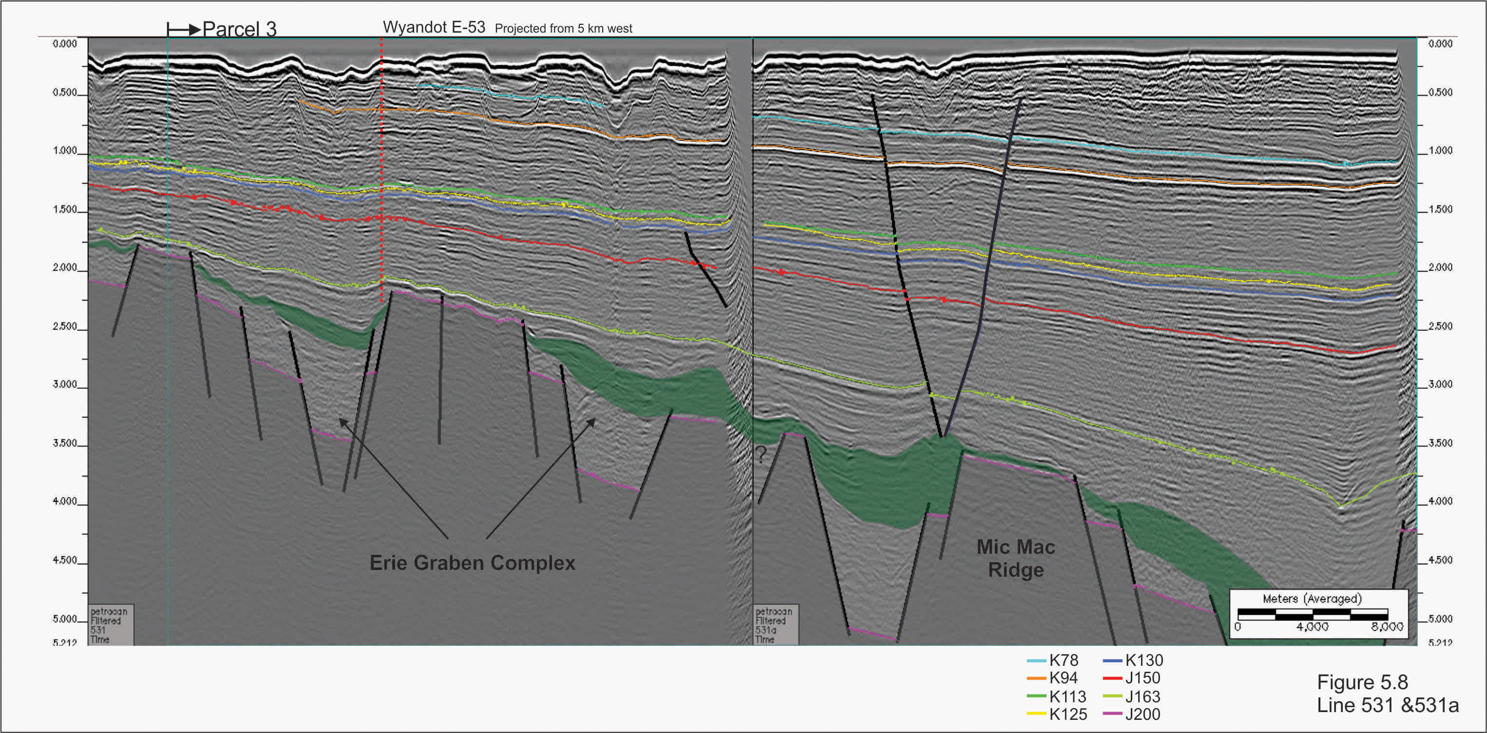
The Callovian MFS is represented in the Scotian Basin by the Misaine Member, and is the only siliciclastic succession within the thick, carbonate-dominated Abenaki Formation. The velocity contrast between the Misaine MFS shales and underlying Scatarie Member (J213) platformal limestones results in the creation of an excellent regional seismic marker (Figure 5.8). As such, the Misaine can be mapped throughout the Scotian Basin though is lost in the distal parts of the basin. It is present deep in the Sable and Huron subbasins though has been penetrated in wells drilled near and on the basin hingeline fault and on the LaHave Platform.
There is limited information available on the source rock potential of the Misaine in the NS13-1 Call parcels. In the Abenaki Subbasin, geochemical analysis in the Abenaki J-56 well revealed Type IIA-IIB and II-III oil- and gas-prone kerogens with a TOC of 2.0% (Mukhopadhyay and Wade, 1990). The HI and OI levels indicate that the Misaine is only partially depleted in its generative potential (HI=100) that is consistent with the level of maturity (Ro=0.8%) as applied to a Type II kerogen (OETR, 2011).
This source rock interval is significantly shallower in the Abenaki Subbasin than in the Huron, and probably not yet fully depleted. It is possible that the basement structural elements still had an influence upon sedimentation in the early Middle Jurassic to the extent that water circulation in the basin was inefficient and resulted in more restricted marine conditions and associated water stratification and anoxia. In this setting the potential exists to create and preserve oil-prone organic matter (Types I and II/IIA kerogens). This interval (or a deeper one) could be the source of the Mic Mac J-77 oil that migrated into higher reservoirs from proximal, adjacent depocentres up along late-phase (Tertiary) faults.
- Early Jurassic – Pleinsbachian to Toarcian restricted to near-normal marine (Mohican and Iroquois Formation distal equivalents)
Though not yet penetrated by the drill bit, empirical evidence increasingly supports the presence of an oil-prone, Type II marine Pleinsbachian to Toarcian age regional source rock interval in the Scotian Basin.
The most recent compilation and assessment of source rocks in the Scotian basin is that of the OETR’s 2011 Play Fairway Analysis (PFA). The PFA reviewed and consolidated extant data and interpretations with new data acquired from analyses of bottom seeps (GeoMark, 2001), as well as undertaking its own analyses. From these data and comparative study with known source rocks from other circum-Atlantic basins, a new, fifth regional source rock interval is inferred. The following section is more comprehensive than the preceding given the importance of this interval to the Call for Bids play area, and potentially the deep water region of the southwestern Scotian Slope. Unless otherwise indicated, the following is sourced from the PFA.
An important recent contribution to evaluating the Scotian basin’s source rocks was a study by GeoMark (2001) and incorporated into the PFA. This study analysed piston core samples taken along the deepwater Scotian Slope, and compared the extracted hydrocarbons with those from the Scotian Basin (shallow water) and the Jeanne d’ Arc Basin, Newfoundland (Hibernia Field). In addition to this correlation were interpreted their respective ages and depositional environments, and potential thermal maturation trends.
The analytical results revealed these oils were distinctive from the Jeanne d’ Arc and Scotian Shelf oils. The low pristine/phytane versus C19/C23 ratio indicated they were similar to the Newfoundland oils with both sourced from a source dominated by Type II oil-prone kerogen. The Scotian Shelf oils indicated a Type III gas-prone kerogen source. However, analysis of saturate and aromatic hydrocarbon fractions for stable carbon isotope composition revealed that the seep oils were different from both regions. Comparison of terpane mass chromatograms against GeoMark’s proprietary global oil data base suggests that the oils match those sourced from distal marine shales and/or calcareous shales / marls. All piston cores samples from the Scotia Basin showed low levels of gammacerane, a biomarker indicative of stratified water columns during the time of deposition (Sinninghe-Damste et al., 1995). The low level of gammacerane in these samples would infer deposition under less restricted, more normal marine conditions though with some water stratification. The oleanane biomarker (a product from angiosperm remains) was absent, confirming the source was older than Late Cretaceous.
OETR (2011) compared these analyses with its own for oils, condensates and source rock extracts from selected Scotian Basin wells and similar biomarker data from other sources. A condensate sample from the Venture B-13 well from the shallow water Venture gas field (DST #6, 4572-4579 m, base Early Cretaceous Missisauga Fm.) revealed the presence of gammacerance which was confirmed to have come from an indigenous source and not a contaminate. Traces of gammacerane were also found in fluid inclusions from the Late Triassic-Early Jurassic Argo Formation salts in the deep water Weymouth A-25 well, and the homohopane ratio C35/C34=1 suggesting a carbonate depositional environment for the source.
OETR (2011) then compared the analyses with data from Early Jurassic (Pleinsbachian-Toarcian), oil-prone source rock successions from conjugate eastern Atlantic margin basins such as the Portuguese Lusitanian and Peniche basins, and the Essaouira and Tarfaya basins of Morocco. The Portuguese source rock successions are composed of marine black shales, marls and carbonates deposited on a carbonate ramp setting. They contain Type II kerogens and tend to have high gammacerane levels and very high TOCs. Duarte et al. (2010, 2012) analysed the latest Sinemurian to earliest Pleinsbachian Água de Madeiros Formation in the Lusitanian Basin. Though the succession is immature onshore (Ro<0.45), it is an excellent potential source rock offshore with its organic-rich (Type II kerogen) shales, marls and limestones having maximum TOC ranges of 15-22%. Additional geochemical data on these source rocks’ geochemical properties and distribution in these basins is presented in Silva et al. (2011, 2012). In the Peniche Basin, Pleinsbachian age Type II source rocks have a similar TOC maximum range of 14-20% (avg. 3.8%) (Veiga de Oliveira et al., 2006 as referenced in OETR, 2011).
From the Moroccan offshore margin, analysis of extracts from Toarcian age source rocks from the DSDP Leg 79, Site 457 (Hinz et al., 1982; Rullkötter et al., 1984) differ from those in the Portuguese basins. While deposited in a similar deposition setting, the oils reveal no to low (background) levels of gammacerane. The shale / carbonate succession was similar but did not exhibit any characteristics of hypersalinity or stratified water conditions. Further to the south, biomarker analyses of oils from the Sidi Rhalem Field (onshore Essaouira Basin) and offshore Cap Juby Field (offshore Tarfaya Basin) were made available to OETR from GeoMark. They revealed in both the low levels of gammacerane, and C35/C34 ratios being less than one also inferring a carbonate dominated source. There is a good match of the isotopic signatures with the Nova Scotia piston core oil samples, suggesting a similar age source and depositional environment. Though the source interval(s) is uncertain, Morabet et al. (1998) suggest that for these regions it is carbonate-dominated Type II source and ranges from Lower Jurassic (presumed Pleinsbachian to Toarcian) to Oxfordian in age.
A recent paper by Sachse et al. (2012) studied the organic geochemistry and source rock potential of a Pleinsbachian to earliest Toarcian succession of limestones and marls further to the east in the central portion of the Middle Atlas Rift. The kerogens were determined to be Type II or transitional Type I/II with TOCs ranging from 1.1 to 3.9%. Analysis of a representative sample (Tab. 5 & Fig.8B) reveals little to no gammacerane. The succession is interpreted to have been deposited in marine depositional environment with a stratified water column with bottom waters that were oxygen-depleted but not anoxic.
New evidence for a Scotian Basin Early Jurassic source rock comes from the analysis by Sassen and Post (2007) of a condensate sample from the Deep Panuke gas field (Late Jurassic Abenaki Formation, M-79A well). Detailed analysis of the sample included GC-MS for common biomarkers and diamondoids, and GC-IRMS for carbon isotopic properties of saturate and aromatic fractions. The GC-MS revealed pristine and phytane with very low peaks in relation to adjacent n-alkanes indicating the condensate underwent advanced thermal cracking during deep burial prior to migration in the leached and dolomitized reef margin reservoir. The thermal maturity index was defined as TAI=0.95 that approximates a Ro=1.4, and diamondoid levels in the condensate were very high (~1%) indicative of high thermal cracking of the original oil. While common biomarkers were lost from this petroleum, traces of key ones are present, the most important (for this review) being gammacerane. With the low pristine/phytane ratio (1.23), this supports the interpretation of a hydrocarbon from a Type II marine source. In comparison, the average pristine/phytane ratio for the piston core samples was also low at 1.43 (n=12; 1.23 to 1.56) (GeoMark, 2001). Sassen and Post (2007) suggest that the source lithologies were a calcareous shale or carbonate, which reflects the same interpretation by the GeoMark study.
It is possible that a second, slightly older Early Jurassic source could exist. It would have been deposited immediately post-salt and prior to the pre-Breakup Unconformity during the Hettangian to earliest Sinemurian representing a transitional evaporate to siliciclastic succession (Argo Formation to Heracles unit). The proposed Pleinsbachian to Toarcian source interval was deposited post-BU and the distal (seaward) equivalent to the Mohican (clastic) / Iroquois (carbonate) succession. During the development of the margin in the Late Triassic to Early Jurassic, the depositional setting changed from a subsea level rift basin to a narrow and shallow intra-rift seaway. Hydrographic conditions would likewise reflect this change, and in this near equatorial location evolve from hypersaline to near hypersaline / normal marine conditions that would contribute to water stratification. While gammacerane is low to absent in the Moroccan oils, this cannot be used alone as a diagnostic feature of a Toarcian age source rock, though this might be a clue to infer these oils are post-BU with marine waters approaching normal salinities. The low gammacerane levels in the Nova Scotia oils may also suggest mixing / diluting of pre- and post-BU oils. The respective source rocks would be separated by an unconformity and could possibly overly each other and thus have the same maturation profile with mixing of produced hydrocarbons during concurrent migration. This two source rock scenario remains speculative.
- Late Triassic – Carnian-Norian lacustrine to restricted marine (Eurydice Formation and equivalents)
A sixth potential source rock interval may exist though there is no direct evidence for its presence offshore. Onshore eastern North America, Late Triassic to Early Jurassic fluvial-lacustrine-playa successions are found in synrift, half graben basins of the Newark Supergroup (Olsen, 1997). Some of these basins have identified source rocks, and a few oil shows are known. In the shallow parts of the Scotian Basin (i.e. LaHave Platform), similar basins are present but devoid of organic material. However, outboard of the basin’s hingeline half graben architectures are observed on seismic and they are inferred to exist beneath the Argo Formation salts in deeper parts of the basin. Kettanah (2011) identified liquid and vaporous hydrocarbons in fluid inclusions within salts of the Late Triassic-Early Jurassic Argo Formation from the Glooscap C-63 and Weymouth A-45 wells. The characteristics of the liquids were determined to be characteristic of “complex, high molecular weight, aromatic or cyclic hydrocarbon compounds higher than methane”. The author commented that given their stratigraphic position, the potential source could have been the underlying sediments of the Norian-Rhaetian Eurydice Formation.
Later analysis of the fluid inclusions revealed that gammacerane biomarker was absent in the authochthonous salts in the former well, but present in the allochthonous salts of the latter (see Pl.4-3-6, OETR, 2011). The profile was considered very similar to one for a condensate sample from the Deep Panuke gas field. The PP3C well condensate sample had a very similar homophone C34-C35 ratio (~1.0) inferring a carbonate depositional environment for the source facies (Fowler and Obermajer, 1999). This sample was obtained from the Late Jurassic Abenaki Formation carbonate reservoir that was probably from an older, deeper and more mature source interval as indicated by Sassen and Post (2007). The arid, redbed depositional environment represented by the Eurydice sediments is based on limited penetrations along the basin margin, though the succession could be different and more favourable for source rock deposition in the deeper parts of the rift basin.
Maturation
As part of the Play Fairway Analysis (OETR, 2011) 1D, 2D and 3D basin modelling was performed utilizing the Temis™ software that incorporated data on petroleum system elements and processes. From all available data, Common Risk Segment (CRS) maps were created to illustrate the presence, maturity and migration of source rock intervals (CRS maps for reservoir and seal were also created for all intervals). Composite CRS maps were generated for five designated petroleum systems for the Scotian Basin. Burial history and maturation were modelled deriving information from published and newly acquired datasets.
For selected wells, temperature, maturation and pressure data were derived to generate well and composite regional burial curves for temperature, maturation (vitrinite reflectance, Ro) and pressure. Maturation history and potential expelled hydrocarbons were calculated utilizing input parameters for each source rock interval (age, TOC, kerogen type, initial hydrogen index, thickness) (OETR, 2011; Plate 7-3-1-3a). Incorporating these data and results into the Temis™ 3D modelling were generated the transformation ratio (TR) for through time for selected source rock and play intervals for the entire Scotian Basin (TR = observed versus initial hydrogen index; differs for kerogen type) (OETR, 2011, Plate 7-3-1-3b).
Within the Call for Bids region, five wells were used for calibration in the 3D petroleum systems modelling (Note: 31 wells were used for the entire Scotian Basin):
Abenaki Subbasin:
- Chippewa G-67
- Missisauga H-54
Huron Subbasin:
- Sachem D-76
- South Griffin J-13 *
- West Esperanto K-78 *
Other data related to determining the source rock intervals’ properties and maturation were sourced from the following wells:
Newly Acquired TOC & Rock Eval Data (OETR, 2011)
- Chippewa L-75
- Erie D-26
- Iroquois J-17
Existing TOC & Rock Eval Data (Geological Survey of Canada’s “BASIN” online database):
- Abenaki J-56
- Dauntless D-35 *
- Iroquois J-17
- Louisbourg J-47
- Peskowesk A-99
- South Griffin J-13 *
- West Esperanto B-78 (CNSOPB Database) *
Existing Maturation Data (Geological Survey of Canada’s “BASIN” online database):
- Abenaki J-56
- Chippewa L-75
- Dauntless D-35 *
- Hesper I-52
- Iroquois J-17
- Louisbourg J-47
- Mic Mac H-86
- Mic Mac J-77
- Missisauga H-54
- Sachem D-76
- South Griffin J-13 *
- West Esperanto B-78 *
- Wyandot E-53
Note: Asterisk (*) indicates a PFA “Bible” well.
The following section reviews the characteristics of the five known, and one speculative / potential, source rock intervals with emphasis on the Jurassic Tithonian and Pleinsbachian-Toarcian intervals. It should be noted that extrapolation of the Temis™ modelling results into the outer margins of the basins was required, with the hingeline zone in the northern parts of Parcels 2-6 having little to no results generated / presented (OETR, 2011).
MAJOR Source Rock Intervals
Late Jurassic: Tithonian carbonate to deltaic transition MFS (Abenaki / Upper Mic Mac to Lower Missisauga formations) – Dominantly OIL & GAS
Modelling of this source interval in the PFA (OERA, 2011) revealed that this source interval should be considered as a significant contributor to the Scotian Basin’s hydrocarbon endowment. As described above, it represents deposition in a transitional setting from a carbonate-dominated marine (Abenaki) to siliciclastic fluvial-deltaic environment. The source interval lithologies have an average TOC of about 3% composed of mixed Type IIA/IIB-III kerogens capable of generating gas, condensate and oil (Mukhopadhyay and Wade, 1990). The deposition of this source is regional in scope centred in the central and eastern parts of the Scotian Basin. The interval’s transformation ratio progressively increases from the hingeline basinward up to a maximum of about TR=60% in the depositional lows behind the South Griffin Ridge in the Huron Subbasin, and isolated ones inboard of the Abenaki’s Missisauga Ridge. None of this source interval is overmature in the Call region (Figure 3.1).
Early Jurassic: Pleinsbachian to Toarcian restricted to near-normal marine (Mohican and Iroquois Formation distal equivalents) – Dominantly OIL
As discussed previously, this proposed source rock is based on the analysis of oils recovered from several well tests and piston cores; it has yet to be encountered in a well. Petroleum systems modelling (Temis™) suggests that this source interval is the only one that reaches maturity in the southwest platform, margin and slope of the Scotian Basin (OETR, 2011). In the southeastern part of the Call region (Parcels 34-6), modelling indicates that there was near complete expulsion of hydrocarbons (TR=90-100%, oil, minor gas). However, most of the Abenaki Subbasin (Parcels 2-4) and northern third of the Huron Subbasin are not included in the modelling (Figure 3.2). Nevertheless, it is theorized here that this region could be the location for the development of a significant source rock that is still mature.
The presence of shallow underlying and adjacent basement structural elements during the Early Jurassic would have exerted an influence on the seafloor morphology and water circulation. In this setting, there would be good potential to generate anoxia in local depocentres in which sediments with high TOC, oil-prone would be deposited. Oils generated from this source rock would have migrated into an adjacent / overlying reservoirs and preserved there over time with a very effective overlying seal. A second phase of migration could have occurred much later in time due to fault breaching of the seal. For the Mic Mac J-77 oil discovery, Tertiary age faults above a deep salt are the likely migration pathways. They may have been created in response to shaking of the Scotian Margin shallow basement by the 50.5 Ma Montagnais impact event to the southwest.
This deep source / reservoir scenario may also be reflected in the thermally overmature oils identified in the Late Jurassic Abenaki Formation fractured, leached and dolomitized carbonates of the Deep Panuke field (Sassen and Post, 2007). This high thermal maturity supports the idea that these oils were undisturbed for a long period of time prior to late phase migration. Unfortunately, there are no analyses of the Mic Mac J-77 oil to confirm its source and maturation level. If this scenario is valid, then the modelled high- to over-maturation of this potential source rock underestimates its potential.
MINOR Source Rock Intervals
Early Cretaceous: Intra-Aptian deltaic MFS (Naskapi Member, Logan Canyon Formation) – Dominantly GAS, Minor OIL
In the Abenaki and northern half of the Huron subbasins, the Naskapi is thin and dominated by coarser grain siliciclastics. It is present high in the stratigraphic section and thus is immature. It becomes thicker in the southern half of the Huron Subbasin and easternmost extension of the Sable Subbasin inboard of the South Griffin Ridge. Here its deeper burial depth increases its maturity with a transformation ratio up to 40% though with limited generation of hydrocarbons (mostly gas). It is not interpreted to have any hydrocarbon contributions in the Call for Bids region.
Early Cretaceous: Berriasian / Valanginian deltaic MFS (Lower Missisauga Formation) – Dominantly GAS
In the Abenaki Subbasin this source rock interval, and indeed the entire Missisauga Formation, is sand-dominated with little shale present. It is shallow and thus immature with no hydrocarbons (gas) generated. This source interval is better developed in the southern part of the Huron Subbasin and eastern sable Subbasin (Parcels 4-6) inboard of the sag behind the South Griffin Ridge, though the Missisauga Formation sand/shale ratio is high and source intervals are thin. Nevertheless, some hydrocarbon expulsion is predicted by modelling, with gas dominating.
Middle Jurassic: Callovian marine MFS (Misaine Member, Abenaki Formation) – Dominantly GAS, Minor OIL
As described previously, the Misaine Member is widespread across the Call region and Scotian Basin. This source rock has incomplete (40-80%) expulsion of hydrocarbons (gas, minor oil), being immature along the basin hingeline margin and mature elsewhere except for the southern half of the Huron and Abenaki subbasins where it is overmature; TR=80-100% (Parcels 3-6) (Figure 3.3). However, it is acknowledged that due to limited data an accurate estimate of the Misaine’s potential is uncertain (OETR, 2011). This has significant implications regarding its modelled generative potential, thus it has an undetermined upside potential. It is this region that may have to most potential Misaine source rock upside. Like the potential early Jurassic source interval, the presence of underlying basement structural elements during the time of its deposition could have exerted an influence on its formation though to a lesser degree. Gas generated from this source interval might be that encountered and tested in the lower part of the Mic Mac Formation in the Louisbourg J-47 well.
POTENTIAL Source Rock Interval
Late Triassic: Carnian-Norian lacustrine to restricted marine (Eurydice Formation and equivalents) – Dominantly GAS, Minor OIL
For most of the Call region, potential source rocks from this interval would be deeply buried beneath the Argo Formation evaporites and invariably overmature. Their maturity would be lower adjacent to the border fault zone, and in the small half grabens along its crest (Eire Graben Complex) where pre-BU strata are present. Short distance migration from either source location could be evidenced by the oil staining and minor oil pay identified in the shallow Eire D-26 and Wyandot E-53 wells.
Hydrocarbons
The Scotian Basin is primarily gas-prone based on the great volume of source rock successions that had significant input from deltaic depositional systems. Most discoveries and production were of gas with associated condensates, yet there are a number of significant oil shows and discoveries, and previous oil production.
Since the late 1970s, researchers have undertaken analyses of these liquids in order to classify them and derive information related information on maturation and source rock relationships. Powell and Snowdon (1979) defined three oil and condensate families source predominantly by terrestrially dominated deltaic and marine shales of the Mic Mac, Missisauga and Verrill Canyon formations. In the 1990s, P.K. Mukhopadhyay undertook a comprehensive study of Scotian Basin hydrocarbon and source rock characterizations and relationships in association with the Geological Survey of Canada with a number of important papers and research contributions published. Mukhopadhyay et al. (1995), using cluster analysis of polyaromatic compounds, defined two oil families. Group I is comprised of high maturity condensates and associated gas derived from a terrestrial source (Type IIB/III kerogens). Group II oils from the Cohasset-Panuke-Balmoral fields suggest a marine source generated from mixed organic matter types (Type IIA/III kerogens).
In a geochemical analysis of oils and condensates from the Sable Subbasin, Illich et al. (1999) defined five oil families (three larger groupings). Two Families, A and B, were determined to have been generated from terrestrial type (III) organic matter from two closely related sources. The third, Family C, may represent the products of oil mixing since they have geochemical compositions indicative of terrestrial (Type III prodeltaic) and marine (Type II, carbonate-rich) source rocks. The remaining oils were grouped into two catch-all families, D and E. These contain very mature oils, some with unique compositions, and others that might be contaminated with drilling additives. They all have slightly different maturities that could represent separate source intervals. A Family D oil from the Venture D-23 well (4889m, DST No.4, 6U sand, Missisauga Fm.*) contained an above background level of gammacerane though the source rock and its age is unknown, but could be from an older, Early Jurassic source. (* Note: Illich et al. (1999) do not indicate the formation and DST number, and the 4771 m sample depth is incorrect.)
Fowler and Obermajer (2001) defined three families of liquid hydrocarbons (1, 2 and 3a & 3b) in the Scotian Basin. Each has characteristic properties, maturation profiles and geographic separation suggesting they came from separate source rocks, with most sourced from terrestrially-derived organic matter (Type II-III). The high gravity (47-55 API) oils from the Cohasset, Panuke, Balmoral and Penobscot fields are from Family 1 and are probably the least mature. Family 2 oils are found in the Arcadia, Banquereau, Glenelg and North Triumph shelf-edge fields in the Sable Subbasin and were generated from rocks with greater levels of higher land plant material than the others, or, that they are less mature. Family 3 oils may be due to a mixture of the Family 1 and 2 oils. Since Family 1 oils are only found in the Cohasset area on the west side of the Sable Subbasin, and Family 2 in the North Triumph area in the south, this significant geographic separation supports the interpretation that they are from different sources. This study indicated that the Scotian basin oils and condensates had Ro equivalents of between 0.7 and 0.94% confirming they were generated in the central part of the oil window.


