

Western Scotian Margin
- Introduction and scope
- First-order Structural Subdivisions
- :: LaHave Platform Province
- :: Slope Detachment Province
- :: Allochthonous Salt and Minibasin Province
- :: Outer ECMA Province
- Discussion and Summary
- Figures
NS11-1 Parcel Prospectivity
Location and Coordinates
Geoscience References

NS11-1 Parcel Prospectivity
Figures
If you are having trouble downloading files on this website, please right click the link and choose “Save target As"
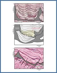
Figure 20
a) Turtle structure in the ASM province (Parcel 3); b) Unique late turtle structure (yellow) perched above a minibasin (Parcel 4); c) Inverted minibasin near the transition of the SD and ASM provinces (Parcel 1) formed as shortening accommodated up-slope gravity gliding.
a) Turtle structure in the ASM province (Parcel 3); b) Unique late turtle structure (yellow) perched above a minibasin (Parcel 4); c) Inverted minibasin near the transition of the SD and ASM provinces (Parcel 1) formed as shortening accommodated up-slope gravity gliding.
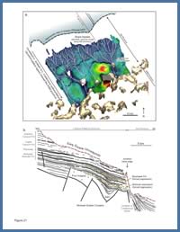
Figure 21
a) Upper Jurassic to Lower Cretaceous time-thickness map showing prominent canyon erosion and resulting thin strata in the proximal SD province, with a significant expansion of strata within the minibasins in the distal SD province and into the ASM province. The steep, out-of-grade slope of the SD province prompted slope bypass through much of the Upper Jurassic and Cretaceous, with a significantly expanded succession preserved within higher accommodation minibasins down-slope. This observation has important implications for the presence and style of potential deepwater reservoirs in the SD versus ASM provinces; b) Seismic profile line drawing from the outer part of the LaHave Platform seaward of Mohawk B-93, showing two intervals of progradation (interpreted forced regressions) that probably delivered sand to the Jurassic slope.
a) Upper Jurassic to Lower Cretaceous time-thickness map showing prominent canyon erosion and resulting thin strata in the proximal SD province, with a significant expansion of strata within the minibasins in the distal SD province and into the ASM province. The steep, out-of-grade slope of the SD province prompted slope bypass through much of the Upper Jurassic and Cretaceous, with a significantly expanded succession preserved within higher accommodation minibasins down-slope. This observation has important implications for the presence and style of potential deepwater reservoirs in the SD versus ASM provinces; b) Seismic profile line drawing from the outer part of the LaHave Platform seaward of Mohawk B-93, showing two intervals of progradation (interpreted forced regressions) that probably delivered sand to the Jurassic slope.