

Western Scotian Margin
- Introduction and scope
- First-order Structural Subdivisions
- :: LaHave Platform Province
- :: Slope Detachment Province
- :: Allochthonous Salt and Minibasin Province
- :: Outer ECMA Province
- Discussion and Summary
- Figures
NS11-1 Parcel Prospectivity
Location and Coordinates
Geoscience References

Western Scotian Margin
Allochthonous Salt and Minibasin Province
The ‘allochthonous salt and minibasin province’ (ASM province) is a ca. 350 km long and 22 to 80 km wide area located outboard the SD province. The profile in Figure 2 crosses its narrowest part. The ASM province is a region dominated by well-developed minibasins and intervening allochthonous salt bodies in present day water depths generally between 1700 and 4050 m, and covering an area greater than 21 000 km2 (Figure 1a). It is bracketed between a Jurassic salt canopy in the west (referred to here as the ‘Shelburne Canopy’) and a series of sutured and reactivated Cretaceous and Paleogene salt sheets to the east (referred to here as the ‘SW Sable Canopy’ – see also Shimeld 2004; Kendell and Deptuck 2010; and Kendell 2011).
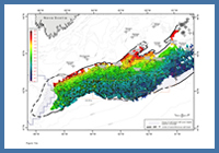
FIGURE: 13a
Gridded time-structure map on the top autochthonous salt surface, correlated along the equivalent primary weld.
Gridded time-structure map on the top autochthonous salt surface, correlated along the equivalent primary weld.
The ASM province corresponds to the seaward parts of salt subprovince II of Shimeld (2004), whose lateral salt subprovince boundaries cut across the proximal to distal structural provinces defined in this study. Despite this subtle difference in classification, much of Shimeld’s (2004) description of subprovince II is focused on the allochthonous salt bodies, and hence is directly applicable to the ASM province of this study.
The landward boundary of the ASM province corresponds to a sharp increase in the density of allochthonous salt bodies down-slope of the SD province. The seaward limit of the ASM province is the distal edge of the underlying autochthonous salt basin (Figures 11, 13b). Any salt bodies extending beyond its seaward limit (generally salt tongues) are considered part of the outer ECMA province, and are discussed in the corresponding section.
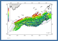
FIGURE: 13b
Gridded time-structure map on the top autochthonous salt surface, overlain by the gridded surface from the top allochthonous salt bodies located predominantly in the ASM province. Autochthonous salt highs produce a polygonal network of minibasins in the ASM province, many of which form the stocks of overlying allochthonous salt bodies.
Gridded time-structure map on the top autochthonous salt surface, overlain by the gridded surface from the top allochthonous salt bodies located predominantly in the ASM province. Autochthonous salt highs produce a polygonal network of minibasins in the ASM province, many of which form the stocks of overlying allochthonous salt bodies.
The autochthonous salt basin in the ASM province is believed to overlie highly extended continental crust. The top of the autochthonous salt layer (or its equivalent primary weld) was interpreted across much of the ASM province (Figure 13a). Seismic correlation confidence is variable, particularly in areas with complex salt overhangs. The geometry of minibasin fill was used as a general guide to mapping this marker. Many of the autochthonous salt highs in Figure 13a form the stocks of overlying allochthonous salt bodies. The somewhat ‘polygonal’ distribution of autochthonous salt highs nicely delimits the earliest supra-salt minibasins that loaded the autochthonous salt layer in the ASM province. The halos of autochthonous salt that rim the earliest minibasins are particularly well imaged in 3D seismic surveys located on the eastern and western extremities of the ASM province. Identification of a base autochthonous salt marker in these areas allows for the generation of autochthonous salt thickness maps that show a general increase in autochthonous salt thickness toward the ASM province (see figure 5 of Deptuck 2010a).
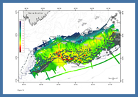
FIGURE: 16
Time-thickness map between the Early Eocene unconformity and the seafloor (approximately a Cenozoic thickness map, minus the Paleocene). Map shows a clear area of Cenozoic minibasins near the centre of the map.
Time-thickness map between the Early Eocene unconformity and the seafloor (approximately a Cenozoic thickness map, minus the Paleocene). Map shows a clear area of Cenozoic minibasins near the centre of the map.
In contrast to most areas of the SD province, 2D seismic imaging below the autochthonous salt layer over much of the ASM province is quite poor (Figure 10). Still, allochthonous salt walls in the ASM province are dominantly oriented in two directions: SW-NE and SE-NW (Figure 13b). These salt bodies are therefore oriented parallel and perpendicular to the dominant direction of basement lineaments in the SD and LP provinces to the northwest, hinting at a potential genetic relationship. In areas with 3D seismic coverage, there is clear evidence that autochthonous salt diapirs are preferentially expelled along basement lineaments (Figures 8, 9) and the apparent preferential alignment of salt walls could reflect a similar process for allochthonous salt bodies (see also Welsink et al. 1989; Balkwill and Legall 1989; Albertz and Beaumont 2010).
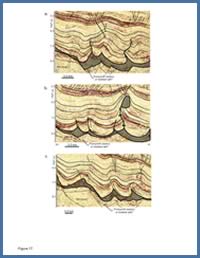
FIGURE: 17
Three seismic profiles across Jurassic to Cretaceous folds in the landward parts of the ASM province in the eastern study area (see Deptuck, 2008).
Three seismic profiles across Jurassic to Cretaceous folds in the landward parts of the ASM province in the eastern study area (see Deptuck, 2008).
Distinct lateral offsets are also recognized in the landward boundary of the ASM province (Figures 1a, 13c). Allochthonous salt bodies here were dominantly evacuated from a chain of minibasins defining the seaward limit of the SD province that are also offset (e.g. Figure 11). These offsets, combined with the orientation of allochthonous salt walls, patterns in magnetic data (Oakey and Dehler 2004), the distribution of basement elements (in the LP and SD provinces), and variations in synrift fault vergence, in totality, imply the presence of SE-NW oriented right-lateral synrift transfer faults that segmented the primary salt basin before, and perhaps during, salt accumulation (Figures 8, 11, 13c, 15b). The orientation of these lineaments is consistent with the transfer faults proposed by Welsink et al. (1989) and the plate reconstruction proposed by Tankard and Balkwill (1989; their figure 3). Such features, combined with northeast trending basement structures, probably influenced both the expulsion of salt (location, timing) and its original depositional thickness.
Though salt diapirism may have been initiated during regional extension (rifting), the majority of the salt expelled from beneath minibasins in the ASM province probably took place through passive loading during postrift subsidence (Shimeld 2004; Albertz et al. 2010), starting in the Jurassic and continuing locally into the Paleogene. With the exception of the area of the Mohican Graben Complex, minibasins are generally much broader and longer lived in the ASM province than they are in the SD province up-slope. The onset of major salt loading probably took place while the Mohican Formation and its equivalents were deposited in the Early or Middle Jurassic (Wade and MacLean 1990).
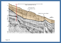
FIGURE: 18
Northwest- to southeast-oriented profile across a thick contourite drift that is thickest above the SD province. Aggradation of this drift may have prompted down-slope squeezing of pre-existing salt diapirs in the ASM province. Profile from Kidston et al., (2005).
Northwest- to southeast-oriented profile across a thick contourite drift that is thickest above the SD province. Aggradation of this drift may have prompted down-slope squeezing of pre-existing salt diapirs in the ASM province. Profile from Kidston et al., (2005).
The most proximal minibasins appear to have welded out the earliest, with distal minibasins active the longest. This general trend is illustrated nicely near the centre of Figure 16 where minibasins above an Early Eocene marker are thickest. Similarly, the depth of burial of the crests of salt bodies by Cenozoic strata tends to decrease in the seaward direction (i.e. proximal salt bodies are typically buried by greater than 1000 ms of Cenozoic strata, whereas the crests of distal diapirs are generally buried by less than 500 ms of strata TWT). In part this reflects an increase in sedimentation rates in more proximal areas, but it is also consistent with salt in most proximal minibasins welding out first, with continued salt expulsion from more distal minibasins.
Most allochthonous salt bodies in the ASM province are broader near their tops than their stocks, and as a result are commonly mushroom or bulb-shaped, with variable amounts of salt overhangs above the minibasins responsible for loading and expelling the salt. Salt bodies are therefore no longer in their original stratigraphic position. Long term narrowing of salt stocks could have been accomplished through passive loading combined with progressive turtle formation (see figure 11 of Albertz et al. 2010) or through shortening of the section to accommodate gravity gliding in the SD province (Deptuck et al. 2009; Deptuck 2010a).
There is an increased tendency toward contractional structures transitioning from the SD province to the ASM province (Figure 17). These structures include detachment folds, fault propagation folds, reverse faults and thrust faults. In some cases the thickest parts of minibasins were inverted (Figure 9), with thrust faults in the basin centre (a structural style that is distinctly different than turtles, which are also recognized). The down-slope contractional response in some areas is quite complex, producing squeezed salt stocks, folds with variably oriented axes, and reverse/thrust faults with variable vergence. These are all believed to be structural products of down-slope shortening that accommodated up-slope extension and gravity gliding in the SD province. Folding continued above the autochthonous salt layer or its primary weld until the mid to Late Cretaceous, and in some areas into the Early Paleogene. Upslope detachment (SD province) and down-slope shortening (proximal ASM province) were therefore highly diachronous. There is also increased influence from the Lower Cretaceous Sable Island Delta towards the northeast, where gravity spreading associated with southward progradation generated a series of down-slope contractional structures that include the Newburn fold-and-thrust belt (Deptuck et al. 2009) penetrated at Newburn H-23 (Figure 1a).
It is noteworthy that many salt diapirs also experienced a younger period of rejuvenation when draped strata above diapirs were folded (Shimeld 2004). In the eastern part of the study area this may be explained by a significant landward step in sedimentation starting in the Miocene, during which a prominent contourite drift, up to 1.5 km thick, migrated up the slope above the eastern SD province (Campbell et al. in prep) (Figure 18). The load from this drift may be responsible for squeezing of diapirs directly down-slope from it, where prominent folds developed in the strata above most diapirs.
Area northwest of Shelburne Canopy:
The area northwest of the Shelburne Canopy (corresponding to salt subprovince I of Shimeld 2004) also contains minibasins flanked by elongated salt walls or isolated diapirs. The SD province inboard this region is very narrow or absent, and consequently the transition from the LaHave Platform is very abrupt (as shown in figure 5a of Albertz et al. 2010). This area is treated separately for the time being, because it is unclear whether all of the salt bodies mapped in this region were sourced from the autochthonous salt layer (with the thickest salt abruptly offset in the landward direction from the ASM province to the east) or were sourced from an allochthon or inflated salt layer expelled from the Georges Bank area.
Seismic coverage and quality are poor, particularly in the western part of this area where the complexity of allochthonous salt bodies also appears to increase (see hachured area in Figure 1). Isolated salt diapirs off the eastern flank of the Yarmouth Arch appear to define the western limit of the autochthonous salt basin, where numerous down-to-the-basin (seaward dipping) listric faults are believed to sole out in a primary salt weld. The Jurassic and Cretaceous succession across this region of listric faults is expanded and the succession probably corresponds to the ‘Shelburne Delta’ comprised of a thick regressive sandstone and shale package that loaded the autochthonous salt basin east of the Yarmouth Arch (Wade and MacLean, 1990, see their figure 5.4). Although poor data coverage makes the link between the region of listric faults (west) and the region of complex diapirs (east) tenuous, it is possible that some of the salt bodies northwest of the Shelburne Canopy formed from reloading of a salt allochthon that was expelled earlier from the Shelburne Delta, in addition to salt bodies that were expelled upwards from the autochthonous salt basin beneath this region. This could explain the extreme difficulty in confidently identifying and mapping the top autochthonous salt surface in this region.