

Western Scotian Margin
- Introduction and scope
- First-order Structural Subdivisions
- :: LaHave Platform Province
- :: Slope Detachment Province
- :: Allochthonous Salt and Minibasin Province
- :: Outer ECMA Province
- Discussion and Summary
- Figures
NS11-1 Parcel Prospectivity
Location and Coordinates
Geoscience References

Western Scotian Margin
LaHave Platform Province
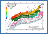
FIGURE: 3
Gridded time-structure map on the top of the Jurassic carbonate bank.
Gridded time-structure map on the top of the Jurassic carbonate bank.
The ‘LaHave Platform province’ (LP province) is an area underpinned by thick continental crust broken locally by Triassic to Early Jurassic rift basins and intervening basement highs (Welsink et al. 1989; Wade and MacLean 1990; Keen et al. 1991). The synrift autochthonous salt basin is known to extend onto the LaHave Platform in the Mohican Graben area where bedded Triassic salt was encountered by the Glooscap C-63 well and probable autochthonous salt was encountered at the base of the Mohican I-100 well (Figure 1a). Lateral facies changes from interbedded salt to immature synrift clastic units are also apparent in the Mohican Graben area where Moheida P-15 encountered time-equivalent rocks of the Eurydice Formation.
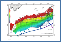
FIGURE: 4a
Gridded time-structure map of the sea floor marker, showing parcel locations.
Gridded time-structure map of the sea floor marker, showing parcel locations.
The seismic character of the bedded salt interval at Glooscap C-63, capped by the Glooscap volcanic layer, was mapped toward the northeast, where the succession is present in a graben on the edge of the LaHave Platform along the western margin of the Sable Subbasin (Figure 1a, north of Evangeline). Further west, the primary salt basin may also extend landward onto the platform in parts of the Mohawk Graben Complex where an interpreted expanded Lower Jurassic section may have been accommodated through salt expulsion in addition to rift subsidence.
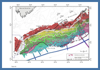
FIGURE: 4b
Gridded time-structure map of the sea floor marker, overlain by key structural provinces described in this study.
Gridded time-structure map of the sea floor marker, overlain by key structural provinces described in this study.
Periods of folding and faulting of the bedded salt to Glooscap volcanic interval in the Mohican Graben area and towards the western margin of the Sable Subbasin attest to the complex synrift evolution of grabens beneath the LaHave Platform. It is clear that the LaHave Platform experienced both extension and localized inversion during rifting that folded the bedded salt interval and also the Glooscap volcanic layer.
There is also clear seismic evidence for sediment loading and salt expulsion throughout the southern parts of the Mohican Graben Complex. Salt appears to have been expelled towards the southwest where several autochthonous and allochthonous salt diapirs are present near the mouth of the complex. Several listric detachment faults are also recognized along the outer parts of the LP province in the Mohican Graben area (Figure 1a). They offset Jurassic strata above the autochthonous salt layer and, combined with the expulsion of salt, are probably responsible for the increased subsidence of the outer LP province in this area (see top Carbonate Bank marker, Figure 3).
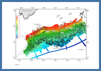
FIGURE: 5a
Gridded time-structure map on a prominent Early Eocene unconformity that formed, at least in part, in response to a 50.8 Ma bollide impact. Scarps and canyon heads within the impact crater are highlighted.
Gridded time-structure map on a prominent Early Eocene unconformity that formed, at least in part, in response to a 50.8 Ma bollide impact. Scarps and canyon heads within the impact crater are highlighted.
A distinct hinge zone defines the seaward boundary of the LaHave Platform, across which basement depth increases abruptly (Figures 1a, 2). The hinge zone separates the relatively stable platform to the north, where rift extension caused only minor crustal attenuation (Tankard and Welsink 1989), from heavily faulted and significantly thinned continental crust to the south. The hinge zone cuts across the primary autochthonous salt basin, particularly in the Mohican Graben area, and likewise steps across numerous other rift-related basement elements. The continuity of basin fill across the hinge zone indicates that sediment loading and salt expulsion in the Mohican Graben area took place at least in part before the hinge zone developed. As such, the hinge zone is believed to have formed after rifting, likely initiated during Early to Middle Jurassic postrift thermal subsidence of the margin (Wade and MacLean 1990; Deptuck 2010a).
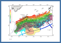
FIGURE: 5b
Gridded time-structure map of the Early Eocene unconformity, annotated to show canyons that transported failed material directly down-slope from the impact site, where a widespread mass transport deposit is recognized. Orange indicates the primary core of the mass transport deposit, while yellow indicates peripheral mass wasted material. There is a high degree of uncertainty about its distribution in deepwater.
Gridded time-structure map of the Early Eocene unconformity, annotated to show canyons that transported failed material directly down-slope from the impact site, where a widespread mass transport deposit is recognized. Orange indicates the primary core of the mass transport deposit, while yellow indicates peripheral mass wasted material. There is a high degree of uncertainty about its distribution in deepwater.
At the termination of rifting, the LaHave Platform experienced low overall subsidence rates and has been dominated by non-marine to outer neritic depositional environments for most of its history. The stable platform is home to a widespread carbonate bank that developed later in the Middle Jurassic after most rift grabens were filled and intervening basement highs were planed off. A time-structure map of the top of the Jurassic carbonate bank shows that the seaward limit of the bank coincides closely to the edge of the LaHave Platform (Figure 3), indicating a close association between carbonate aggradation above a low accommodation shelf and hinge zone development (Welsink et al. 1989). The platform remained a relatively low accommodation shelf through most of the remaining postrift history of the margin, and much of the present day continental shelf still sits directly above it (Figures 4a, 4b).
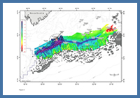
FIGURE: 6
Time-thickness map between the top Jurassic carbonate bank marker and the Early Eocene unconformity, showing the widespread erosion of the Cretaceous to Paleocene stratigraphic succession caused, at least in part, by the bolide impact.
Time-thickness map between the top Jurassic carbonate bank marker and the Early Eocene unconformity, showing the widespread erosion of the Cretaceous to Paleocene stratigraphic succession caused, at least in part, by the bolide impact.
A unique and important structural feature on the LaHave Platform is an Early Eocene (50.8 Ma) impact crater penetrated by the Montagnais I-94 well (Jansa et al. 1989). The impact event caused Cretaceous and Paleocene strata on the outer part of the LaHave Platform to fail catastrophically across a wide area (covering up to 4000 km2). A 65 km wide multi-tiered sub-circular failure scarp developed in the immediate area surrounding the 13 km wide central high (the target of Montagnais I-94), with a second arcuate failure scarp developing west of the impact location (Figure 5a). These scarps cut down as deep as the top of the Jurassic carbonate bank, and are open to the south where a series of deep canyons erode and converge across the slope detachment province (Figure 5b). Additional foundering of the outer LaHave Platform appears to have taken place east of the impact site, where Cretaceous strata are truncated or offset along a series of detachment faults (though at least some of these features appear to be diachronous and hence not exclusively associated with any single event). A widespread mass transport deposit directly down-slope from the failure scarps, up to 300 ms (TWT) thick, is presumed to be the product of the bolide impact and covers an area greater than 14 000 km2 (Figure 5b). It accumulated between salt diapirs and above the Ypresian seafloor seaward of the salt basin, extending for an unknown distance onto the paleo-abyssal plain, beyond data coverage.
The Montagnais structural element is noteworthy because erosion associated with the impact event removed a significant amount of the Cretaceous and Paleocene stratigraphic record across a 170 km long and 10 km to >30 km wide swath of the outer shelf (Figure 6). Therefore the event has potentially erased any record of, for example, shelf-edge deltas above the carbonate platform that may otherwise have been preserved on the seaward parts of this low-accommodation shelf.