

Western Scotian Margin
- Introduction and scope
- First-order Structural Subdivisions
- :: LaHave Platform Province
- :: Slope Detachment Province
- :: Allochthonous Salt and Minibasin Province
- :: Outer ECMA Province
- Discussion and Summary
- Figures
NS11-1 Parcel Prospectivity
Location and Coordinates
Geoscience References

Western Scotian Margin
First-order structural subdivision
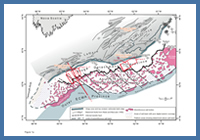
FIGURE: 1a
Map showing key structural elements and four-way post-rift structural subdivision described for the western Scotian Margin in this study. Fault traces on the LaHave Platform are from Wade and MacLean (1990). Note that parts of the autochthonous salt basin underlie the LaHave Platform, Slope Detachment, and Allochthonous Salt and Minibasin provinces. Note also that some parts of the autochthonous salt basin have poor data coverage and hence its margins in these locations are poorly constrained. See text for details.
Map showing key structural elements and four-way post-rift structural subdivision described for the western Scotian Margin in this study. Fault traces on the LaHave Platform are from Wade and MacLean (1990). Note that parts of the autochthonous salt basin underlie the LaHave Platform, Slope Detachment, and Allochthonous Salt and Minibasin provinces. Note also that some parts of the autochthonous salt basin have poor data coverage and hence its margins in these locations are poorly constrained. See text for details.
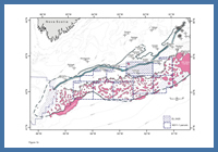
FIGURE: 1b
Map showing location of NS11-1 nominated parcels. Limits of autochthonous salt basin and boundaries between structural provinces are the same as in Figure 1a.
Map showing location of NS11-1 nominated parcels. Limits of autochthonous salt basin and boundaries between structural provinces are the same as in Figure 1a.
The western Scotian Margin includes areas of the modern shelf, slope, and basin floor located west of the Sable Subbasin, and is underlain in part by a Late Triassic to Early Jurassic primary salt basin that formed as Nova Scotia rifted and ultimately broke apart from its Moroccan conjugate (Figure 1a). The western Scotian Margin can be subdivided into four proximal to distal postrift structural provinces, from landward to seaward referred to as the LaHave Platform (LP), Slope Detachment (SD), Allochthonous Salt and Minibasin (ASM), and Outer East Coast Magnetic Anomaly (ECMA) provinces. All four structural provinces were influenced to varying degrees by salt tectonics (Figure 2). The distinctive, common structural style observed in each province reflects a combination of the nature of vertical tectonics during seafloor spreading (for example, the amount and symmetry of postrift subsidence), preconditioned by the margin configuration just prior to continental break-up. In particular, the amount and distribution of synrift salt is believed to have played an important role in determining the extent and style of postrift deformation as different parts of the margin subsided in different ways.
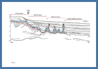
FIGURE: 2
Line drawing of a composite seismic profile extending from the LaHave Platform (LP), across the Slope Detachment (SD) and Allochthonous Salt and Minibasin (ASM) provinces, and terminating in the Outer ECMA province where Seaward Dipping Reflections (SDRs) are recognized. Water column was depth converted, but remaining section is in two-way travel time. See Figure 1a for location.
Line drawing of a composite seismic profile extending from the LaHave Platform (LP), across the Slope Detachment (SD) and Allochthonous Salt and Minibasin (ASM) provinces, and terminating in the Outer ECMA province where Seaward Dipping Reflections (SDRs) are recognized. Water column was depth converted, but remaining section is in two-way travel time. See Figure 1a for location.
This four-way proximal to distal structural subdivision provides useful geological context for the eight parcels in the NS11-1 Call-for-Bids, and provides a first-order assessment of the structural setting of each (Figure 1b). Parcel 1 straddles the SD, ASM and Outer ECMA provinces while Parcels 2 and 5 straddle the ASM and Outer ECMA provinces. Parcels 3 and 4 lie almost exclusively above the ASM province, while Parcels 6, 7, and 8 straddle the SD and ASM provinces. The northern part of Parcel 7 also extends onto the LP province.