

Western Scotian Margin
- Introduction and scope
- First-order Structural Subdivisions
- :: LaHave Platform Province
- :: Slope Detachment Province
- :: Allochthonous Salt and Minibasin Province
- :: Outer ECMA Province
- Discussion and Summary
- Figures
NS11-1 Parcel Prospectivity
Location and Coordinates
Geoscience References

NS11-1 Parcel Prospectivity
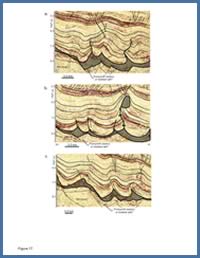
FIGURE: 17
Three seismic profiles across Jurassic to Cretaceous folds in the landward parts of the ASM province in the eastern study area (see Deptuck, 2008).
Three seismic profiles across Jurassic to Cretaceous folds in the landward parts of the ASM province in the eastern study area (see Deptuck, 2008).
Parcel 1 straddles the Slope Detachment(SD), Allochthonous Salt and Minibasin (ASM) and Outer East Coast Magnetic Anomaly (ECMA) provinces while Parcels 2 and 5 straddle the ASM and Outer ECMA provinces. Parcels 3 and 4 lie almost exclusively above the ASM province, while Parcels 6, 7, and 8 straddle the SD and ASM provinces. The northern part of Parcel 7 also extends onto the LP province (Figure 1b).
All eight NS11-1 parcels are located, at least in part, above the allochthonous salt and minibasin (ASM) province on the western Scotian Slope. Most potential hydrocarbon traps here are associated in some way with structures produced by or adjacent to allochthonous salt bodies (diapirs, walls or tongues). Multiple potential drilling targets are present in Cenozoic to Jurassic age strata that can generally be grouped into four categories:
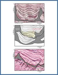
FIGURE: 20
a) Turtle structure in the ASM province (Parcel 3); b) Unique late turtle structure (yellow) perched above a minibasin (Parcel 4); c) Inverted minibasin near the transition of the SD and ASM provinces (Parcel 1) formed as shortening accommodated up-slope gravity gliding.
a) Turtle structure in the ASM province (Parcel 3); b) Unique late turtle structure (yellow) perched above a minibasin (Parcel 4); c) Inverted minibasin near the transition of the SD and ASM provinces (Parcel 1) formed as shortening accommodated up-slope gravity gliding.
a) Structures above salt diapirs: Numerous four-way dip closures are present above salt diapirs in the ASM province. They are commonly associated with younger periods of contraction that squeezed salt stocks and folded overlying Cenozoic strata. Some structures show strong evidence for direct hydrocarbon indicators (DHIs) like flat spots, anomalously high amplitude seismic reflections, and gas chimneys. Strong amplitude variations are also present across some fault planes that offset diapir crests.
b) Structures on salt flanks and below small salt overhangs: Numerous potential three-way closures against salt flanks or below small salt overhangs are present within minibasins of the ASM province (e.g. right side of Figure 17b; left side of Figure 20b). Some cover areas greater than 25 km2 while most are smaller but could have three-way closure at multiple Cretaceous through Cenozoic stratigraphic levels.
c) Structures between salt bodies associated with welded turtles: Structures associated with passive loading and turtle formation have been identified in several parcels. Some of these structures have four-way dip closure areas upwards of 30 km2 (e.g. Figure 20a). A unique turtle structure is found in Parcel 4 (Figure 20b) that may have formed after salt tongues from adjacent feeders covered (or partially covered) the underlying minibasin and was later reactivated during deposition of the yellow unit. It is not known why the flanks of the underlying minibasin did not deflate to form a deeper turtle, but it could indicate that salt below the deeper minibasin still has not welded out.
d) Structures between salt bodies associated with contraction: Numerous structures associated with shortening down-slope from the SD province have been identified in the NS11-1 parcels. In some cases, the entire fill of a minibasin has been inverted, producing structures that can be mistaken for turtles, particularly on profiles oblique to the shortening direction. In Figure 20c, a thrust fault has developed in the basin centre. This configuration probably requires local welding out of the autochthonous salt layer above an angular basement block that then acts as a local buttress. Numerous other contractional structures are recognized in the landward parts of the ASM province, including thrust propagation folds, salt cored detachment folds, and reverse faults (Figure 17).
Parts of Parcels 1, 6, 7, and 8 are also located over the slope detachment (SD) province. A number of potential structural and stratigraphic traps are possible here. Most structures are associated with rotation of rafts above the autochthonous salt layer, in some cases influenced by the rugose faulted geometry of the rocks that underlie the salt. The raised edges of Jurassic rafts form angular discordances that are draped by Cretaceous strata. Such structures could form unconformity traps.
Potential stratigraphic traps include Cenozoic turbidites that onlap the steep slope in the SD province or accumulated above a step on the gradient profile (constructed during aggradation of Neogene contourites; see Campbell and Deptuck, In Press). Some of these onlap traps are associated with strong amplitude anomalies that could be DHIs.
Finally, the landward part of Parcel 7 extends onto the carbonate bank (LP province), where the bank is underlain by the autochthonous salt basin (near Albatross B-13; Figure 1b). Here, the presence of salt, coupled with the proximity of the margin hinge zone, causes a large 1.2 sec (twt) thick section of the carbonate bank to detach and rotate, forming a large potential trap near the mouth of the Mohican Graben Complex.