

Western Scotian Margin
- Introduction and scope
- First-order Structural Subdivisions
- :: LaHave Platform Province
- :: Slope Detachment Province
- :: Allochthonous Salt and Minibasin Province
- :: Outer ECMA Province
- Discussion and Summary
- Figures
NS11-1 Parcel Prospectivity
Location and Coordinates
Geoscience References

NS11-1 Parcel Prospectivity
Potential Reservoirs
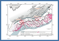
FIGURE: 1a
Map showing key structural elements and four-way post-rift structural subdivision described for the western Scotian Margin in this study. Fault traces on the LaHave Platform are from Wade and MacLean (1990). Note that parts of the autochthonous salt basin underlie the LaHave Platform, Slope Detachment, and Allochthonous Salt and Minibasin provinces. Note also that some parts of the autochthonous salt basin have poor data coverage and hence its margins in these locations are poorly constrained. See text for details.
Map showing key structural elements and four-way post-rift structural subdivision described for the western Scotian Margin in this study. Fault traces on the LaHave Platform are from Wade and MacLean (1990). Note that parts of the autochthonous salt basin underlie the LaHave Platform, Slope Detachment, and Allochthonous Salt and Minibasin provinces. Note also that some parts of the autochthonous salt basin have poor data coverage and hence its margins in these locations are poorly constrained. See text for details.
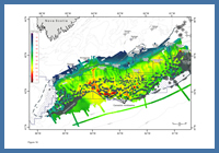
FIGURE: 16
Time-thickness map between the Early Eocene unconformity and the seafloor (approximately a Cenozoic thickness map, minus the Paleocene). Map shows a clear area of Cenozoic minibasins near the centre of the map.
Time-thickness map between the Early Eocene unconformity and the seafloor (approximately a Cenozoic thickness map, minus the Paleocene). Map shows a clear area of Cenozoic minibasins near the centre of the map.
Evaluating the potential for Jurassic and Cretaceous deepwater reservoirs in the areas of Parcels 1 to 8 is hampered by a number of factors. For example, only one well, Shelburne G-29, tests the Jurassic to mid-Cretaceous deepwater succession on the western Scotian Margin, and this well was drilled on the upper SD province above a prominent basement high (rift block) where the pre-Turonian succession is highly condensed or was eroded. The limited number of well penetrations and poor digital seismic quality and coverage on the outer shelf (LP province) also hinders the study of potential depositional systems that could have supplied sands to the shelf edge. This is compounded by widespread erosion after the Montagnais bolide impact that removed parts of the outer shelf where prograding clinoforms from Cretaceous or Paleocene shelf edge deltas, if they existed, would have been found. Still, a number of observations suggest there are several potential shelf sources for deepwater sands on the western slope that warrant further evaluation.
In the Jurassic, three siliciclastic successions are recognized on the platform that may have periodically delivered sands to the paleo-shelf edge. The Lower to Middle Jurassic Mohican Formation, comprised largely of immature clastics, is found below the Bathonian Scatarie Member (carbonate). Landward of Parcels 3 and 4, a pre-Scatarie shelf margin is preserved north and west of Acadia K-62. Here, a rapidly thickening progradational clastic wedge is recognized, containing up to 2000 m of Mohican-equivalent strata (Wade and MacLean, 1990). Similarly, localized pre-Scatarie progradational clinoforms are observed near the Albatross B-13 well (below TD) and in the outer parts of the Mohawk Graben Complex (Figures 1a, 21b). Accommodation for these clastic units was provided through salt expulsion at a time when the hinge zone was in the early stages of development.
The Middle to Upper Jurassic Mohawk Formation, comprised of shallow marine siliciclastics, and its time equivalent Mic Mac Formation, comprised of a mix of clastics and carbonates (Given 1977; Wade and MacLean 1990) are known to exist inboard the Jurassic carbonate bank along the western part of the margin. Here, these formations have traditionally been considered the proximal equivalents of the Abenaki Formation that occupies the outer rim of the LaHave Platform. However, there are some indications that the inboard clastic systems periodically breached the carbonate bank. For example, Mohawk B-93 penetrated a 505 m thick texturally mature sand-dominated Upper Jurassic interval, of which 194 m were porous sands averaging 23% porosity (Given 1977). On the outer platform seaward of the Mohawk B-93 well location, an interval of prograding clinoforms is present above the Scatarie marker defining a 150 ms thick (two-way time) forced regressive wedge that was abruptly truncated at the margin hinge zone (Figure 21b). This provides clear evidence that the inboard clastic systems were able, at least locally, to prograde across the carbonate bank delivering sediment directly to the steep slope that characterizes the SD province.
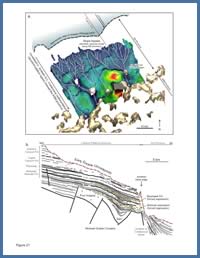
FIGURE: 21
a) Upper Jurassic to Lower Cretaceous time-thickness map showing prominent canyon erosion and resulting thin strata in the proximal SD province, with a significant expansion of strata within the minibasins in the distal SD province and into the ASM province. The steep, out-of-grade slope of the SD province prompted slope bypass through much of the Upper Jurassic and Cretaceous, with a significantly expanded succession preserved within higher accommodation minibasins down-slope. This observation has important implications for the presence and style of potential deepwater reservoirs in the SD versus ASM provinces; b) Seismic profile line drawing from the outer part of the LaHave Platform seaward of Mohawk B-93, showing two intervals of progradation (interpreted forced regressions) that probably delivered sand to the Jurassic slope.
a) Upper Jurassic to Lower Cretaceous time-thickness map showing prominent canyon erosion and resulting thin strata in the proximal SD province, with a significant expansion of strata within the minibasins in the distal SD province and into the ASM province. The steep, out-of-grade slope of the SD province prompted slope bypass through much of the Upper Jurassic and Cretaceous, with a significantly expanded succession preserved within higher accommodation minibasins down-slope. This observation has important implications for the presence and style of potential deepwater reservoirs in the SD versus ASM provinces; b) Seismic profile line drawing from the outer part of the LaHave Platform seaward of Mohawk B-93, showing two intervals of progradation (interpreted forced regressions) that probably delivered sand to the Jurassic slope.
The distribution of such deposits elsewhere on the margin is not known. Further east, Wade and MacLean (1990) described an unconformity within the Scatarie Member at Acadia K-62 that may be equivalent to the upper prograding clastic wedge in Figure 21b. It is possible that the record of sea level lowstands across much of the low-accommodation LaHave Platform is expressed by thin forced regressive wedges that are preserved only where enough accommodation exists along the outer platform. Elsewhere, lowstands in sea level may be expressed as single disconformable surfaces within the carbonate bank that are difficult to identify on seismic profiles.
In the Cretaceous, deltas on the LaHave Platform may also have delivered sand to the shelf edge. Lower Cretaceous strata (Berriasian to early Aptian) are condensed above the LaHave Platform west of Mohican I-100, where they are largely represented by carbonates with intervening clastics of the Roseway Unit (Wade and MacLean, 1990). However, parcels located furthest east may contain Lower Cretaceous turbidite sand reservoirs sourced from sand-rich deltas along the western Sable Subbasin (Deptuck, 2008). Aggradation and progradation of Logan Canyon to Dawson Canyon formation clastics later in the Cretaceous may also have supplied sands to the edge of the LaHave Platform inboard Parcels 4, 5, and 6. On seismic profiles near Oneida O-25 and Acadia K-62, for example, multiple erosional features (incised valleys?) are recognized in this shelf interval. Further west, however, widespread erosion of this interval along the margin hinge zone makes sand delivery to the shelf edge hard to evaluate (see Figure 6).
Interestingly, several periods of Jurassic and Cretaceous canyon incision are recognized all along the SD province. Though the grade of clastics is not known, they indicate that sediment was periodically transported from the margin hinge zone, down the steep slope, and toward the ASM province. Figure 21a shows a dendritic network of canyons cut the steep slope seaward of the hinge zone. Upper Jurassic to Lower Cretaceous strata are thin across this region, but seismic markers diverge down-slope into a significantly expanded section, indicating a transition from sediment bypass to sediment accumulation. Here, well-developed Upper Jurassic to Lower Cretaceous minibasins with up to 2 km of sediment are found in the distal parts of the SD province and into the ASM province. Several ‘chains’ of similar interconnected Jurassic and Cretaceous minibasins are observed all along the margin in front of this bypass slope, and these basins warrant further study to determine their potential for trapping turbidite sands.
Finally, there are several locations along the western margin where Cenozoic strata prograded to or beyond the shelf-edge, with a number of canyons that could have transported sands into deep water. The thickest Cenozoic minibasins are located in the central parts of the ASM province in the area of Parcels 1 to 4 (Figure 16), and these basins may have formed the primary sink for Cenozoic turbidite systems.
Next - Source Rocks and Maturity