

Western Scotian Margin
- Introduction and scope
- First-order Structural Subdivisions
- :: LaHave Platform Province
- :: Slope Detachment Province
- :: Allochthonous Salt and Minibasin Province
- :: Outer ECMA Province
- Discussion and Summary
- Figures
NS11-1 Parcel Prospectivity
Location and Coordinates
Geoscience References

Western Scotian Margin
Outer ECMA Province
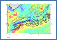
FIGURE: 15a
Magnetic map of western Scotian Margin (from Oakey and Dehler, 2004), overlain by the interpreted transfer faults, allochthonous salt bodies and rift faults and graben complexes from Wade and MacLean (1990).
Magnetic map of western Scotian Margin (from Oakey and Dehler, 2004), overlain by the interpreted transfer faults, allochthonous salt bodies and rift faults and graben complexes from Wade and MacLean (1990).
The East Coast Magnetic Anomaly (ECMA) forms a prominent magnetic lineament along the eastern US margin that continues with a more complex character along southwest Nova Scotia (Klitgord and Schouten 1986; Keen et al. 1990). It splits into two parallel components (Dehler 2010), with an inner component that appears to be more irregular with wide offsets along its landward side, and an outer band that does not appear to show any major offsets (except for an abrupt bend just east of the Shelburne salt canopy), but does show some lateral variations in magnetic intensity (Figure 15a).
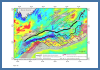
FIGURE: 15b
Magnetic map of the western Scotian Margin (from Oakey and Dehler, 2004), overlain by key structural elements and the four postrift structural provinces described in this study. Note that much of the ASM province overlies the inner part of the ECMA, whereas the outer band of the ECMA lies outside the interpreted seaward boundary of the autochthonous salt basin.
Magnetic map of the western Scotian Margin (from Oakey and Dehler, 2004), overlain by key structural elements and the four postrift structural provinces described in this study. Note that much of the ASM province overlies the inner part of the ECMA, whereas the outer band of the ECMA lies outside the interpreted seaward boundary of the autochthonous salt basin.
It is clear that the autochthonous salt basin, and specifically the ASM province, occupies the inner irregular band of the ECMA (Figure 15b). In contrast, the ‘outer ECMA province’ corresponds to the outer band of the magnetic anomaly found seaward of the ASM province and seaward of the primary salt basin. It ranges in width from ca. 15 km (east) to 60 km (west), and merges with the full width of the ECMA toward the southwest. The landward boundary of the outer ECMA province closely coincides with the seaward limit of the autochthonous salt basin. The landward parts of the province are commonly overlain by salt tongues towards the east (the “salt overhang trend”) and the larger Shelburne Canopy to the west (Figure 15b).
Data coverage across the outer ECMA province is limited in some areas (especially towards the northeast), but there appears to be a lateral trend in the seismic expression of reflective ‘basement’ rocks below Jurassic strata along this province. In the southwest, where the outer ECMA province is widest, basement rocks correspond to a broad region of seaward-dipping reflections (SDRs) (Keen et al. 1990; Keen and Potter 1995; Shimeld 2004). Towards the northeast, where the outer ECMA province is narrowest, the basement character is still quite reflective, but is dominantly flat-lying with only subtle hints of SDRs.
Regardless of the reflective basement character along the outer ECMA province, its seaward limit appears to coincide with an abrupt increase in basement faulting, rugosity, and relief that takes place near the seaward edge of the ECMA. The ECMA has commonly been used to approximate the boundary between continental and oceanic crust (Klitgord and Schouten 1986; Keen et al. 1990). Keen et al. (1990) suggested in one scenario that the transition between the smooth and rough areas could correspond to a transition from basaltic rocks extruded above continental rocks (smooth) transitioning into true oceanic crust that underwent extension during and after its formation (rough).
Along the northeast US margin, the anomaly is known to be associated with SDRs (Keen and Potter, 1995) that formed near the end of rifting as a series of subaerial lava flows during a “brief but voluminous” period of extrusion (Jackson et al. 2000) that marks the end of rifting on volcanic margins (see also Larsen et al. 1994). Although there is significant debate about how far to the northeast subaerial volcanism continued along the Scotian Margin (see OETR Association 2011), if the flatter lying reflective character of basement in the narrowest part of the outer ECMA province (inboard the faulted oceanic crust) is a product of subaerial volcanism, it implies that the western Scotian Margin, and its Moroccan conjugate, were above sea level during earliest break-up. This period of subaerial “seafloor spreading” could have allowed salt, as well as restricted marine source rocks, to have accumulated in a restricted basin prior to widespread thermal subsidence of the margin taking place (Jackson et al. 2000; OETR Association 2011).
It is noteworthy that on a few seismic profiles it appears that the autochthonous salt layer can be correlated a short distance below the SDRs, supporting the view that the SDRs are younger than the salt, and that their emplacement bisected the original synrift autochthonous salt basin (see OETR Association 2011), at least along the western part of the margin.