

Western Scotian Margin
- Introduction and scope
- First-order Structural Subdivisions
- :: LaHave Platform Province
- :: Slope Detachment Province
- :: Allochthonous Salt and Minibasin Province
- :: Outer ECMA Province
- Discussion and Summary
- Figures
NS11-1 Parcel Prospectivity
Location and Coordinates
Geoscience References

Western Scotian Margin
Slope Detachment Province
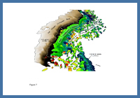
FIGURE: 7
Perspective view from the southwest showing the relationship between the Jurassic carbonate bank, slope detachment province, and the allochthonous salt and minibasin province. This image illustrates the striking absence of allochthonous salt diapirs in the slope detachment province.
Perspective view from the southwest showing the relationship between the Jurassic carbonate bank, slope detachment province, and the allochthonous salt and minibasin province. This image illustrates the striking absence of allochthonous salt diapirs in the slope detachment province.
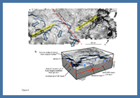
FIGURE: 8
a) Planform view of a mid-Jurassic seismic marker (dip map) showing headscarps of detached slabs (blue) of Jurassic strata in the Slope Detachment Province. Two northeast trending rift blocks define structural highs in the 3D seismic survey that may be offset by a transfer fault; b) Perspective view showing low angle listric faults that detach in the autochthonous salt layer. Note the preferential expulsion of salt along rift block. Blue arrows indicate detachment direction. See Figure 1a for location.
a) Planform view of a mid-Jurassic seismic marker (dip map) showing headscarps of detached slabs (blue) of Jurassic strata in the Slope Detachment Province. Two northeast trending rift blocks define structural highs in the 3D seismic survey that may be offset by a transfer fault; b) Perspective view showing low angle listric faults that detach in the autochthonous salt layer. Note the preferential expulsion of salt along rift block. Blue arrows indicate detachment direction. See Figure 1a for location.
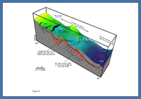
FIGURE: 9
Perspective view of a mid-Jurassic seismic marker showing thin-skinned detachment and extension above a variably thick autochthonous salt layer, and resulting down-slope contraction that produces a thrust. Basement below the salt is heavily faulted. See Figure 1a for location.
Perspective view of a mid-Jurassic seismic marker showing thin-skinned detachment and extension above a variably thick autochthonous salt layer, and resulting down-slope contraction that produces a thrust. Basement below the salt is heavily faulted. See Figure 1a for location.
The ‘slope detachment province’ (SD province) is a ca. 350 km long and 15 to 55 km wide area on the western Scotian Margin dominated by raft tectonics. It runs parallel to, and outboard of, the LaHave Platform in current water depths generally between 500 and 2500 m, covering an area of ~13 000 km2 (Figures 1a, 7). The SD province was named in recognition of the tendency of Jurassic and to a lesser extent Cretaceous cover strata to detach above the autochthonous salt layer across wide expanses of this structural province (Figures 8, 9; Deptuck 2010a).
The landward boundary of the SD province closely corresponds to the structural hinge zone that parallels the Upper Jurassic carbonate bank (Figures 3, 7). Its distal boundary follows the seaward margins of a chain of subcircular minibasins from which allochthonous salt bodies were widely expelled along the leading edge of the allochthonous salt and minibasin province (Figures 10, 11).
In areas where the Moho can be identified, the SD province coincides with the region of most rapidly thinned continental crust (Figures 2, 10) (see also Keen et al. 1991). Mid-crust detachment surfaces, along which rift block faults sole out, are also common (see Deptuck 2010b). In contrast to the consistently low regional gradients above the LaHave Platform, the depth of rifted basement (and the autochthonous salt basin above it) increases abruptly seaward of the hinge zone, producing a steep postrift slope that dominated this structural domain throughout most of its postrift history. Even the modern seafloor on the western part of the margin ultimately owes its steep gradients to the foundering of deeply buried rifted basement across the SD province, producing a slope that commonly exceeds 5° (see figure 16 of Piper et al., In Press) (Figure 4b).
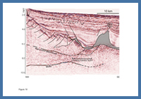
FIGURE: 10
Close-up seismic profile of middle parts of Figure 2 (SD to proximal ASM province), showing prominent northwest-dipping faults that may detach in a mid-crustal detachment surface. Slow water column velocities were depth converted, but remaining section is in TWT.
Close-up seismic profile of middle parts of Figure 2 (SD to proximal ASM province), showing prominent northwest-dipping faults that may detach in a mid-crustal detachment surface. Slow water column velocities were depth converted, but remaining section is in TWT.
Allochthonous salt bodies are rare or absent in the SD province, and where they do exist, they tend to be clustered around the mouth of the Mohican Graben Complex (Figure 1a). The general absence of salt overhangs improves seismic imaging compared to the area down-slope that is dominated by allochthonous salt bodies with overhangs. Crustal seismic markers, faults, the autochthonous salt layer, and cover strata are locally very well imaged in the SD province, particularly in 3D seismic data (Figures 10, 12). Autochthonous salt diapirs, in the form of local salt swells and cone-shaped diapirs are common in the SD province, but are firmly rooted to the autochthonous salt layer and hence the salt is still situated in its original stratigraphic position (Figures 8, 9).
FIGURE: 11
Close-up of the top autochthonous salt to primary weld marker, showing the synrift ‘fabric’ produced by underlying rift blocks, with offsets on minibasins interpreted to be caused by a transfer fault. The figure also illustrates the transition from the SD province to the ASM province where allochthonous salt bodies were expelled from a chain of minibasins along the base of the image. Shallow areas are red, deep areas are purple. See Figure 1a for location.
Close-up of the top autochthonous salt to primary weld marker, showing the synrift ‘fabric’ produced by underlying rift blocks, with offsets on minibasins interpreted to be caused by a transfer fault. The figure also illustrates the transition from the SD province to the ASM province where allochthonous salt bodies were expelled from a chain of minibasins along the base of the image. Shallow areas are red, deep areas are purple. See Figure 1a for location.
A distinct northeast to southwest fabric exists on the top autochthonous salt to primary weld marker across much of the SD province (Figures 11, 12, 13c). This fabric is believed to be an expression of the underlying highly rugose rifted basement that underlies, and is partially masked by variably thick remnants of autochthonous salt. Faulted basement blocks, including their internal stratigraphy, are particularly well imaged in the Barrington 3D seismic survey (program NS24-P3-4E) (Figure 12). The orientation of these basement lineaments is consistent with that of the half-grabens and intervening horst blocks on the LaHave Platform (Welsink et al. 1989; Wade and MacLean 1990), lending support to the idea that the rugose basement fabric is a product of rifting. It is not clear if the synrift succession in the SD province experienced a period of inversion as seen in the bedded salt to Glooscap volcanic interval on the LaHave Platform.
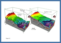
FIGURE: 12
a) Perspective view sculpted along the top autochthonous salt to primary weld marker, showing the synrift fabric below a thin veneer of autochthonous salt. The landward-dipping (northwest) extensional basement faults are well imaged; b) Perspective view showing a series of seaward dipping listric faults within Jurassic cover strata that sole out into the thin autochthonous salt layer. Fault vergence is in the opposite direction of the northwest-dipping synrift faults. See Figure 1a for location.
a) Perspective view sculpted along the top autochthonous salt to primary weld marker, showing the synrift fabric below a thin veneer of autochthonous salt. The landward-dipping (northwest) extensional basement faults are well imaged; b) Perspective view showing a series of seaward dipping listric faults within Jurassic cover strata that sole out into the thin autochthonous salt layer. Fault vergence is in the opposite direction of the northwest-dipping synrift faults. See Figure 1a for location.
The deformation style within Jurassic cover strata above the autochthonous salt layer (or its primary weld) in the SD province is dominated by thin-skinned detachment and associated raft tectonics (Figure 14). The resulting structures look quite similar to the raft tectonic structures documented above postrift Aptian salt on the Angolan Margin (e.g. Fort et al. 2004), with the exception that the base salt surface is faulted and consequently highly rugose in the SD province on the Scotian Margin (Figures 8b, 9, 12, 14). Jurassic strata are commonly offset along low angle listric faults that sole out in the autochthonous salt layer. These faults define the headward parts of detached ‘slabs’ of Jurassic strata, and are commonly composed of a series of shorter arcuate fault traces that link-up to produce longer detachment trends extending along strike for >60 km. The headscarps of some detached slabs coincide with the steep flanks of underlying basement fault blocks, presumably because of the increased propensity for gravity gliding (detachment) in such areas (e.g. southeast side of Figure 14). Where the autochthonous salt basin extends northward below the Middle to Upper Jurassic carbonate bank (e.g. in the Mohican Graben area), parts of the outer bank foundered in a similar manner, with rotated limestone dominated blocks as thick as 1.2 sec (twt) detaching above the autochthonous salt layer near the margin hinge zone.
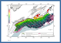
FIGURE: 13c
Annotated map of the top autochthonous salt gridded surface, showing location and orientation of basement lineaments and the interpreted location of transfer faults that appear to offset the landward margin of the ASM province.
Annotated map of the top autochthonous salt gridded surface, showing location and orientation of basement lineaments and the interpreted location of transfer faults that appear to offset the landward margin of the ASM province.
In general, slab detachment is normal to the margin hinge zone, however, the northeast orientation of some positive-relief basement blocks locally alters the detachment trajectory (Figure 8), particularly on slope segments where the hinge zone is oblique to northeast trending basement elements (like much of the margin between the Shelburne and Acadia wells; Figures 1, 13c). Detachment of cover strata was likely initiated in the late-Early to Middle Jurassic and is probably coincident with over steepening of the margin during hinge zone development (Deptuck et al. 2009; Deptuck 2010a). Though extensional structures dominate the SD province, some detached rafts are overthrust above equivalent strata (Figure 14).
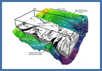
FIGURE: 14
Rafted blocks detaching above high-relief basement veneered with autochthonous salt.
Rafted blocks detaching above high-relief basement veneered with autochthonous salt.
It is noteworthy that several periods of widespread canyoning are recorded across the SD province, where Late Jurassic, Cretaceous and lower Paleogene slope strata are deeply incised, indicating that during postrift subsidence of the margin the SD province repeatedly formed an important slope bypass zone. As such, in addition to structural decoupling of strata above the autochthonous salt layer, the steep gradient across the SD province makes it prone to sediment bypass, an idea with important implications for the distribution of turbidite sands along the western margin (discussed in the Parcel Prospectivity section).