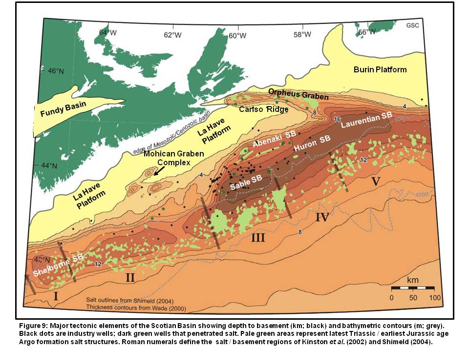
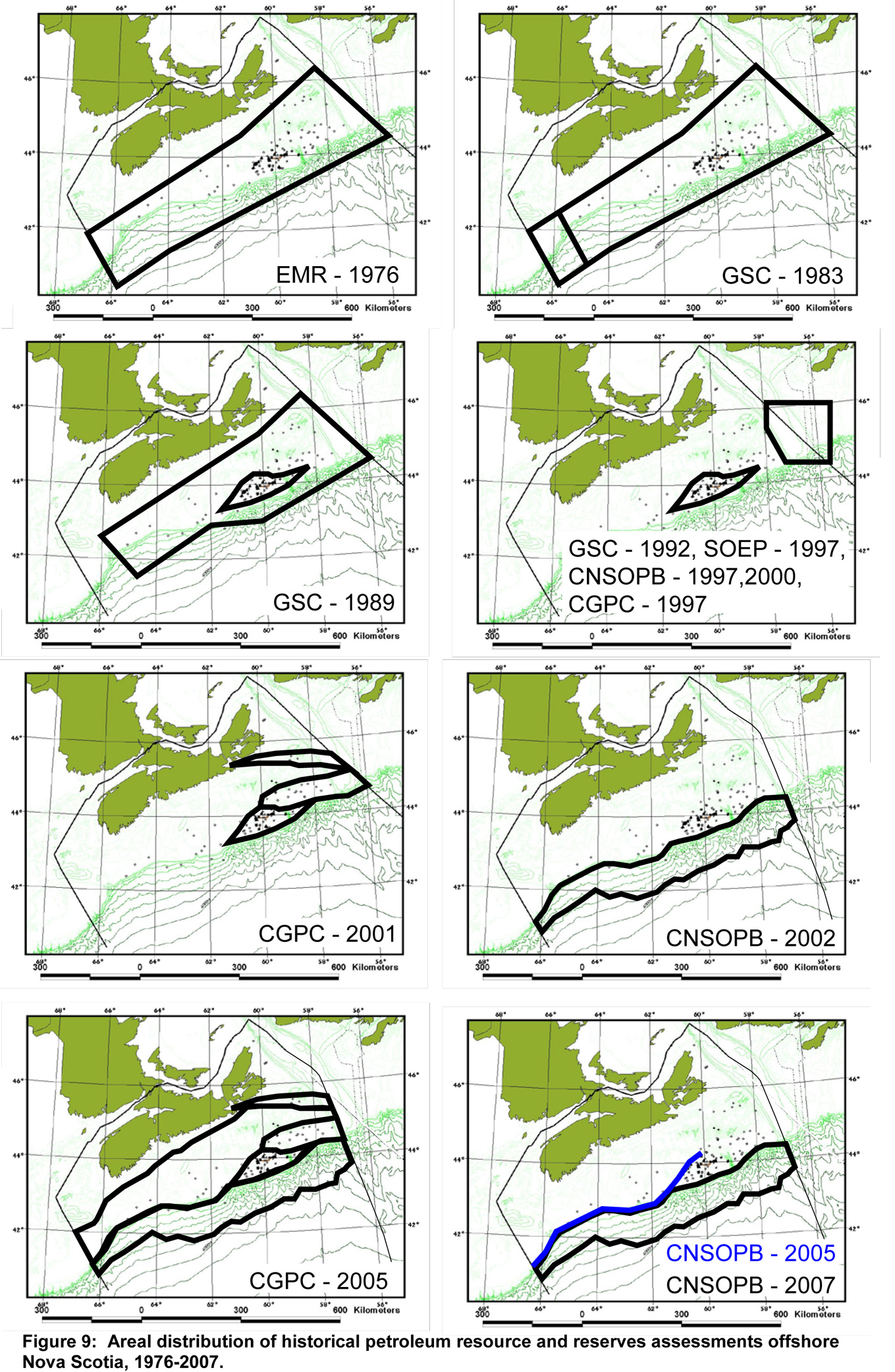
Regional Resource Potential
The first published report on the resource potential for offshore Eastern Canada - "Oil and Natural Gas Resources of Canada, 1976" - was published by Energy, Mines and Resources Canada (1977). Eastern Canada was divided into several regions and the "Atlantic Shelf South" covered the entire continental shelf off Nova Scotia and Newfoundland up to latitude 46 degrees north. The hydrocarbon resource potential (plus discoveries) median value (P50) was estimated at 368 E9M3 (13 Tcf) of gas and 302 E6M3 (1.9 BBbls) of oil and liquids. Using data available to the end of 1975, six gas and oil fields had been discovered in the Sable Island area totaling about 31.1 E9M3 (1.1 Tcf) and 15.9 E6M3 (100 MMBbls) respectively. Based solely on the pro-rating of areas, one-third of the combined Nova Scotia and Newfoundland resources was attributed to the Scotian Shelf, i.e. 122.7 E9M3 (4.3 Tcf) gas and 100.7 E6M3 (633.3 MMBbls) oil. The areal coverage of the various assessments discussed here, and the location of the basin's depocentres and features can be found in Figure 9 and Figure 10 respectively.
The Geological Survey of Canada’s report by Proctor et al. (1984) defined the physiographic Scotian Shelf to the 1500 m isobath. Discovery totals were listed as 111.7 E9M3 (3.9 Tcf) gas and 14.2 E6M3 (89.3 MMBbls) oil. The overall P50 potential (including discoveries) was reported as 508 E9M3 (17.9 Tcf) and 72 E6M3 (452.9 MMBbls). In addition, the undrilled George's Bank (Shelburne Subbasin) was assessed separately at 150 E9M3 (5.3 Tcf) and 168 E6M3 (1.1 BBbls). Previously, Nantais (1983) provided a detailed review of the petroleum systems of the Scotian Shelf, though he did not assess and generate potential hydrocarbon reserve and resource numbers.
The GSC 1984 report was the benchmark assessment for the Scotian Shelf for the subsequent 20 years and the 18 Tcf figure became a widely quoted number and rightly so. However, in light of the 42 wells drilled in the basin since their 1982 data cutoff, and the discovery of 116 E9M3 (4.1 Tcf) gas and 14.4 E6M3 (91 MMBbls) of oil, it became obvious that a new regional assessment was required.
In 1989 the GSC expanded the 1984 report by assessing the basin on the basis of play types (Wade et al., 1989). It determined that the overall P50 gas number (“median expectation, proven plus potential”) remained at 512.4 E9M3 (18.1 Tcf) but with a significant increase of oil and condensate potential to about 171 E6M3 (1.1 BBbls). The population of anomalies for each play type was based on cumulative anomaly mapping by the then regulator Canadian Oil & Gas Lands Administration (COGLA) using data submitted by Industry over the years that it entered the public realm.
The GSC later published a paper on the petroleum geology of the Laurentian Subbasin (MacLean and Wade, 1992). This subbasin lies to the northeast of the Sable, and Huron Subbasins juxtaposed to the Scotian Shelf. According to the distribution of anomalies defined by the authors, about 25% of the potential 249 E9M3 (8.8 Tcf) gas and 100 E6M3 (630 MMBbls) oil-condensates was assumed to exist in Nova Scotia waters. However, following the March 2002 judicial resolution of the inter-provincial boundary dispute with Newfoundland, little of that potential now lies within the CNSOPB's jurisdiction.
In 1997, several publications addressed the discoveries in the Sable Island area (Sable Subbasin). The Sable Offshore Energy Project (SOEP) consortium submitted their Development Plan Application and assigned a “mean raw recoverable [gas] reserves” amount of 84.3 E9M3 (3.0 Tcf) to the six fields; Venture, Thebaud, North Triumph (Tier 1) and Alma, South Venture and Glenelg (Tier 2) (SOEP, 1997). In March 1997 (slightly revised in 2000), the Board published a technical report reassessing all 22 discoveries that had been granted Significant Discovery status. A cumulative mean / BCE recoverable total of 163.8 E9M3 (5.8 Tcf) gas and 29.7 E6M3 (187.8 MMbbls) oil and condensate was established (CNSOPB, 2000).
Also in 1997, the Canadian Gas Potential Committee (CGPC) published a gas assessment for Canada but numbers for offshore Nova Scotia were limited to the Sable Subbasin (CPGC, 1997). They used the discovery data from the Board’s 1997 assessment (slightly revised in 2000) assessment and, for the first time, an in-place undiscovered potential was calculated at 314.3 E9M3 (11.1 Tcf). The total discovered and undiscovered initial in-place volumes of gas for the Sable Subbasin was therefore noted as 498.4 E9M3 (17.6 Tcf).
Within the CGPC's next report, “Gas Potential of Canada” (2001), the Scotian Basin was addressed in its geological entirety that included offshore Nova Scotia and southeastern Newfoundland (Wade and MacLean, 1990). To cope with the lateral variations across the Scotian Basin, it was subdivided into ten geological entities of subbasins or play areas. This analysis was the first attempt to assess the basin by its various components, though excluded the Georges Bank basin (Shelburne Subbasin), LaHave Platform, and deep water slope region. A three-fold play category was employed; established, proven (i.e. having sufficient drilling data to carry out an assessment), and conceptual (where only qualitative descriptions could be accomplished). Once again, the only established play area that could be fully assessed was the Sable Subbasin. An anomaly map released by the Province of Nova Scotia’s Petroleum Directorate in 1999 – based on the original CNSOPB and COGLA compilations - was used to guide the assessment. The defined "Panuke Segment" of the Late Jurassic Abenaki carbonate bank edge, although the Deep Panuke proven play (via various press releases from the operator PanCanadian), could only be assigned a value for the one discovery since technical information was still confidential at that time. Finally, the conceptual plays were assessed with assigned geologic risk factors because the petroleum systems were unproven.
The results were 164.2 E9M3 (5.8 Tcf) initial in-place recoverable gas in the Sable Subbasin, plus an undiscovered initial in-place recoverable gas potential of 150.1 E9M3 (5.3 Tcf) for a combined total of 314.3 E9M3 (11.1 Tcf). The Panuke segment of the Late Jurassic Abenaki Carbonate Bank Edge was assigned 28 E9M3 (1.0 Tcf) nominal initial marketable (recoverable) gas based on the Deep Panuke discovery. The undiscovered potential of the Abenaki Subbasin and Orpheus Graben were assessed at a mean risked gas-in-place of 201 E9M3 (7.1 Tcf) and 37 E9M3 (1.3 Tcf) respectively. Expressing the above in risked mean recoverable terms, the total was 580.5 E9M3 (20.5 Tcf) gas.
In late 1998, PanCanadian (later to become EnCana), made a significant gas discovery on the reef margin facies of the Late Jurassic Abenaki formation, located beneath its shallower Panuke oil field (Early Cretaceous Missisauga formation). After delineation and exploration drilling, they filed a Development Plan (PanCanadian, 2002). Their probabilistic OGIP reserves estimates for Deep Panuke were 31 E9M3 (1.09 Tcf) (P50) and 33 E9M3 (1.16 Tcf) (EV - Expected Value, Mean). This Development Plan was later withdrawn, resubmitted in 2006 by the new corporate entity EnCana, and approved by the CNSOPB in late 2007 (EnCana, 2006). The revised mean in-place gas estimates for Deep Panuke were 28.9 E9M3 (1027 Bcf) with mean recoverable reserves of 18.6 E9M3 (659 Bcf).
In September 2001, the CNSOPB determined that an evaluation of the hydrocarbon potential was required for the deep-water Scotian Slope region under its jurisdiction. Industry’s recent activity in permit acquisition, exploration seismic and drilling, the development and production of Sable gas and application for development of the Deep Panuke gas discovery indicated the need for the Board to have a comprehensive numerical assessment of the offshore resource potential, in particular it deepwater region. The Board’s assessment of the risked and unrisked undiscovered gas potential for this region revealed a mean potential for between 424.8 and 1161 E9M3 (15-41 Tcf) of gas depending on the assumed geological risk factors (Kidston et al. 2002). The oil potential of 318 to 795 E6M3 (2-5 Bbls) is very significant and in keeping with the high oil to gas discovery ratios seen in other global deep water areas. The lateral ranges for the unrisked and risked categories indicated the broad spectrum of possible outcomes given that the next round of deep water exploration had yet to take place. Additionally, the associated gas and natural gas liquids were also significant. The impact of these numbers, on a risked basis, was to basically double the gas potential of offshore Nova Scotia while adding significant oil potential. In other words, adding the traditional 512.4 E9M3 (18.1 Tcf) from the shelf to a risked value of 424.8 E9M3 (15.0 Tcf) for the slope gives a total potential of 937.2 E9M3 (33.1 Tcf). Similarly, adding the traditional 159 E6M3 (1 BBbl) of oil (and liquids) to the 318 E6M3 (2 BBbls) for the slope offers a total potential of 477 E6M3 (3 BBbls of oil).
In its last report, the CGPC incorporated a number of industry, consultant, government and regulatory reports, publications and assessments in its determination of resources and reserves for the Scotian Basin (CGPC, 2005). It duplicated its previous 2001 assessment framework and determined that the basin's total gas-in-place P50 gas resource endowment is 1192.0 E9M3 (42.1 Tcf), of which 212 E9M3 (7.5 Tcf) has been discovered and 980 E9M3 (34.6 Tcf) undiscovered, a 53% increase from the 2001 report. Within the Sable Subbasin, overall reserves and resources estimates were reduced based on production information from the five SOEP fields in production, recent exploration drilling, and revisions to field size distributions. Liquid petroleum resources were not assessed.
Following industry's drilling of six deep water exploration wells (2001-2004), the CNSOPB reevaluated its 2002 assessment of the Scotian Slope (Kidston et al., 2007). It concluded that its original estimates were modestly affected by the recent drilling given that most of the 12 plays assessed remained undrilled: one well tested a subsalt play, another an interpreted Tertiary fan that turned out to be a slump feature (a play type not included in the 2002 assessment), and the remaining four testing anticlinal structures clustered outboard of the Sable Delta. While gas was discovered in two of the four wells, this latter play was slightly downgraded with higher risks assigned to presence of reservoir.
The reassessment of three of the 12 plays reduced the risked mean recoverable gas from 430 to 328 E9M3 (15.2 to 11.6 Tcf), a reduction of 102 E9M3 (3.6 Tcf) or 24%. Similarly, the unrisked mean recoverable was reduced from 1164 to 1090 E9M3 (41.1 to 38.5 Tcf), a reduction of 26 E9M3 (2.6 Tcf) or 6%. The net result is the undiscovered gas potential of 425 to 1164 E9M3 (15 to 41.1 Tcf) has been revised to 340 to 1104 E9M3 (12 to 39 Tcf), a modest reduction within the overall range of probabilistic analysis. The risked recoverable oil fraction was similarly reduced from a mean of 270 to 207 E6M3 (1.7 to 1.3 BBbls), and the unrisked mean was reduced from 4.7 to 4.5 BBbls.
Following the disappointing results of the exploration wells drilled on the deepwater Scotian Slope, the Province of Nova Scotia acknowledged that a re-evaluation and modern understanding of the entire Scotian Basin’s geological evolution, petroleum systems and prospectivity was required. In 2009, C$15 million was invested to undertake a comprehensive and encompassing research project that included participation of industry, government organizations and academia geoscientists. The Play Fairway Analysis, released in 2011 (OETR, 2011), provided a reassessment of the Soctian Basin resource potential.
The six zones delineated in the report included five potential source rocks and five active play systems and simple four-way closed structures (fault-bounded and stratigraphic traps were not incorporated). The petroleum volumes calculated by the Temis™ petroleum systems modelling program estimated that the Scotain Basin has an unrisked yet-to-find volume of 3426 E9M3 (121 Tcf) gas and 1.3 E6M3 (8.2 BBbls) oil.
References
Canada-Nova Scotia Offshore Petroleum Board (CNSOPB), 2000
Technical Summaries of Scotian Shelf Significant and Commercial Discoveries, 257p.
(Also available on the CNSOPB website: http://www.cnsopb.ns.ca/pdfs/Technical%20summaries%20of%20Scotian%20Slope.pdf)
Canadian Gas Potential Committee, 2005
Natural Gas Potential in Canada in 2005 – Frontier Basins of Canada (Volume 3).
Canadian Gas Potential Committee, Calgary, 120p.
Canadian Gas Potential Committee, 2001
Natural Gas Potential in Canada - 2001.
Canadian Gas Potential Committee, Calgary, 527p.
Canadian Gas Potential Committee, 1997
Natural Gas Potential in Canada - 1997.
Canadian Gas Potential Committee, Calgary, 113p.
EnCana Corporation, 2006
Deep Panuke Offshore Gas Development – Development Plan.
Deep Panuke Development Plan Application - Volume 2, 293p.
Energy, Mines, and Resources Canada, 1976
Oil and Natural Gas Resources of Canada.
Department of Energy, Mines, and Resources Canada, Report EP 77-1, 76p.
Kidston, A.G., Brown, D.E., Smith B.M. and Altheim, B., 2002
Hydrocarbon Potential of the Deep-Water Scotian Slope.
Canada-Nova Scotia Offshore Petroleum Board, Halifax, 111p. CD-ROM and
http://www.cnsopb.ns.ca/pdfs/Technical%20summaries%20of%20Scotian%20Slope.pdf
Kidston, A.G., Smith, B., Brown, D.E., Makrides, C. and Altheim, B., 2007
Nova Scotia Deep Water Offshore Post-Drill Analysis – 1982-2004.
Canada-Nova Scotia Offshore Petroleum Board, Halifax, Nova Scotia, 181p.
http://www.cnsopb.ns.ca/pdfs/Technical%20summaries%20of%20Scotian%20Slope.pdf
MacLean, B.C. and Wade, J.A., 1992
Petroleum geology of the continental margin south of the islands of St. Pierre and Miquelon, Offshore Eastern Canada.
Bulletin of Canadian Petroleum Geology, vol.40, no.3, p.222-253.
Nantais, P.T., 1983
A reappraisal of the regional hydrocarbon potential of the Scotian Shelf.
Geological Survey of Canada, Open File Report No.1175, 76p.
OETR Association, 2011.
Play Fairway Analysis Atlas - Offshore Nova Scotia.
Nova Scotia Department of Energy Report, NSDOE Records Storage File No. 88-11-0004-01, 347p.
http://www.offshoreenergyresearch.ca/OETR/OETRPlayFairwayProgramMainPage/tabid/402/Default.aspx
PanCanadian Energy Corporation (EnCana), 2002
Deep Panuke Offshore Gas Development
Deep Panuke Development Plan Application - Volume 2, 145p.
Procter, R.M., Taylor, G.C. and Wade, J.A., 1984
Oil and Natural Gas Resources of Canada 1983.
Geological Survey of Canada, Paper 83-31, 59p.
Wade, J.A. and MacLean, B.C., 1990
Chapter 5 - The geology of the southeastern margin of Canada, Part 2: Aspects of the geology of the Scotian Basin from recent seismic and well data.
In: M.J. Keen and G.L. Williams (Eds.), Geology of Canada No.2 - Geology of the continental margin of eastern Canada. Geological Survey of Canada, p.190-238 (also Geological Society of America, The Geology of North America, Vol.I-1).
Wade, J.A., Campbell, G.R., Procter, R.M. and Taylor, G.C. 1989
Petroleum Resources of the Scotian Shelf.
Geological Survey of Canada, Paper 88-10, 26p.


