Overview
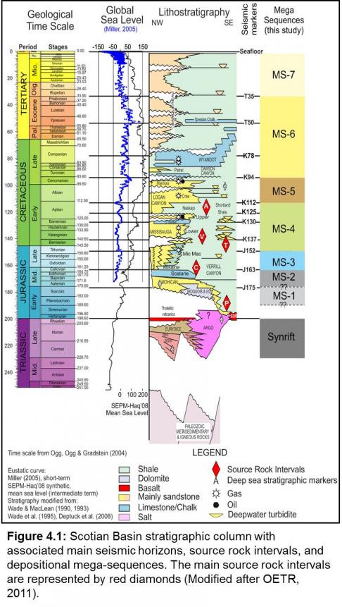
Four regional source rock intervals are known in the Scotian Basin, with a fifth – the Early Jurassic – speculative and based on very limited data. They are grouped into major or minor potential contributors of hydrocarbons based on their geochemical and spatial attributes, depth of burial, maturation and other available data, and all were modelled in the Play Fairway Analysis – PFA (OETR, 2011) (Figure 4.1). The Late Triassic (lacustrine) synrift succession outboard of the basin hingeline could be a sixth source rock interval but has not been penetrated or modelled.
Since the first well in 1967, natural gas has been the predominant hydrocarbon discovered and produced in the Scotian Basin, though significant quantities of condensates and light oils have also been found and produced. Liquid petroleum has been analyzed and differentiated into three to five families as detailed below.
- Early Cretaceous: Intra-Aptian deltaic MFS (Naskapi Member, Logan Canyon Formation) – Dominantly GAS, Minor OIL
- Early Cretaceous: Berriasian / Valanginian deltaic MFS (Middle Member, Missisauga Formation) – Dominantly GAS
- Middle Jurassic: Callovian marine MFS (Misaine Member, Abenaki Formation) – Dominantly GAS, Minor OIL
- Late Jurassic: Tithonian carbonate to deltaic transition MFS (Abenaki / Upper Mic Mac to Lower Missisauga formations) – OIL & GAS
- Early Jurassic: Pleinsbachian to Toarcian restricted to near-normal marine (Mohican and Iroquois Formation distal equivalents) – Dominantly OIL, Minor GAS
Within the Call for Bids NS16-1 Call region, all five defined source intervals were modelled using the Temis™ basin modelling program (1D, 2D and 3D modules) to determine maturation, expulsion, trapped hydrocarbon volumes and characteristics. The speculative Early Jurassic source interval, if present, is modelled to have the best source rock potential for oil and is generating hydrocarbons today. However, this is modelled to occur only in the southwestern deep water portion of the basin (Shelburne Subbasin) and in the NS16-1 region is deeply buried, long since matured and expelled its hydrocarbons and as such is not discussed here.
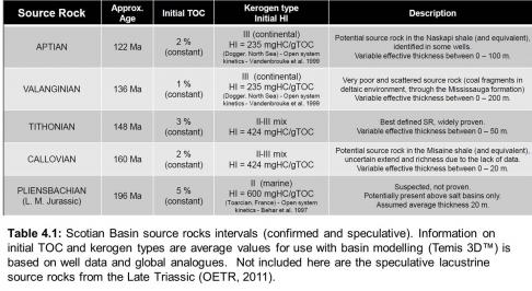
Of the remaining four confirmed source rocks, the Late Jurassic Tithonian is a major source interval with very good potential to generate gas and liquid hydrocarbons from Types II and III kerogens. The two Early Cretaceous intervals – the Berriasian / Valanginian, and Aptian – are minor gas-prone source rocks with limited maturation though some potential may exist in the deep water slope and salt province within localized depocentres. The Middle Jurassic Callovian MFS interval is greatly influenced by deltaic sedimentation though may have potential distally where under marine influence. In all cases, the products of early hydrocarbon generation and migration would be compromised by risks associated with speed and depth of burial, time of maturation and migration, trap preservation, reservoir degradation, local proximity to salt bodies and tectonism.
NOTE: Mapping by the CNSOPB (2012, 2014, and this report) has demonstrated that the near top Jurassic J152 seismic horizon in the deep water region is stratigraphically higher than defined in the OETR Play Fairway Analysis (2011). This revised interpretation places the J152 at least 2 km higher in the northeastern slope region (CNSOPB, 2014) decreasing to about 1 km in the central slope region (NS 16-1 Call for Bids; this report). As a consequence, the Temis™ 1D/2D/3D petroleum systems modelling results in these regions – including NS16-1 Parcels 4, 5 and 6 – overstate the Jurassic’s maturity and expulsion profiles. This new information has been incorporated into an updated model that will be completed and released in the early summer of 2016. As such, the following discussion is based on the existing Temis™ modelling (OETR, 2011).
Source Rock Intervals
Research on the identification and characterization of Scotian Basin source rock intervals has been ongoing since the mid-1970s. Most of the published geochemical research was by researchers of the Geological Survey of Canada (e.g. J.P. Bujak, T.G. Powell, L.R. Snowden, D.R. Issler, M.G. Fowler, M. Obermajer and M.P. Avery) and others such as P.K. Mukhopadhyay (see References for representative citations). Concurrently, the petroleum industry and specialist firms undertook similar studies and analyses, as well as others by consultants and academics, the results of which are available from the CNSOPB’s Geoscience Research Centre / Data Management Centre.
The province of Nova Scotia’s Play Fairway Analysis or “PFA” (OETR, 2011) compiled and updated historical research and existing analyses on petroleum source rocks. It also undertook some new analyses and together utilized these datasets to create a new, basin-wide petroleum systems model. It was recognized that this was a first step and additional research and analyses would be required to improve and expand the model. In 2014 a new regional research initiative was begun to better understand and quantify source rock successions in the Scotian (Mesozoic-Tertiary) and Sydney (Carboniferous) offshore basins. It will include the auditing of existing analyses and data to determine gaps, collection of new piston cores on seeps based on satellite data, organic and inorganic analyses of source rock intervals from wells and outcrops, geochemical analyses of selected oils and extracts from reservoir and sources rock, and new petroleum systems / basin modelling (1D, 2D and 3D). Particular emphasis will be directed towards the western Scotian Basin and confirmation of the Early Jurassic source interval. Results of this major study will be released over the 2016-2017 period.
The cumulative result of the existing studies identified the main source rock intervals, and characterised the properties of several families of oils (Table 4.1). They range from Middle Jurassic to Early Cretaceous age and are marine shales of the Verrill Canyon Formation and its lateral MFS expression within the proximal fluvial-marine successions of the Mic Mac, Missisauga and Logan Canyon formations. Other source rock intervals identified in Early Cretaceous and younger strata have fair to good TOCs (e.g. Logan Canyon Formation; 2-4%). These tend generally to be shallow in the stratigraphic succession, and hence immature. However, sufficient burial does exist along the outer shelf and deep water margins that comprise the majority of the Call for Bids area. As noted above, the fifth marine source rock interval of Early Jurassic age is inferred from geochemical (seep and petroleum analysis) evidence and comparative studies that are described below (OETR, 2011). A speculative sixth source of Late Triassic (Carnian-Norian) is inferred from onshore and nearshore (Fundy Basin) successions and analogues but has no direct evidence to date.
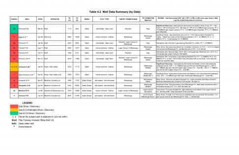
A listing of all twelve wells within and adjacent to NS16-1 Parcels summarizing their hydrocarbon discoveries and shows is presented in Table 4.2.
In the NS16-1 Call region, only the Aptian Naskapi member source interval has been penetrated by the majority of wells and the Berriasian-Valanginian by three (Table 1). Therefore the presence, areal, extent and characteristic of the undrilled source rocks is by necessity based on information from other wells beyond the Call region. This in turn affects the resolution and confidence of petroleum systems and maturation modelling especially when projected into undrilled deep water regions.
|
Well |
Aptian (Naskapi) |
Berriasian- Valanginian (Missisauga) |
Tithonian (Missisauga / Mic Mac) |
Callovian (Misaine) |
|---|---|---|---|---|
|
Annapolis B-24 |
- |
- |
- |
- |
|
Annapolis G-24 |
X |
X |
- |
- |
|
Balvenie B-79 |
X |
- |
- |
- |
|
Chebucto K-90 |
X |
- |
- |
- |
|
Crimson F-81 |
X |
X |
- |
- |
|
Eagle D-21 |
X |
- |
- |
- |
|
Primrose 1aA-41 |
X |
- |
- |
- |
|
Primrose A-41 |
- |
- |
- |
- |
|
Primrose F-41 |
- |
- |
- |
- |
|
Primrose N-50 |
- |
- |
- |
- |
|
Triumph P-50 |
X |
- |
- |
- |
|
West Chebucto K-20 |
X |
X |
- |
- |
Table 1: Source rock intervals penetrated by wells in the NS16-1 parcels and adjacent areas.
Middle Jurassic – Callovian marine MFS
Misaine Member, Abenaki Formation
The Callovian MFS is represented in the Scotian Basin by the Misaine Member, and is the only siliciclastic succession within the thick, carbonate-dominated Middle to Late Jurassic Abenaki Formation. The velocity contrast between the Misaine MFS shales and underlying platformal limestone Scatarie Member (J163 seismic marker) results in the creation of an excellent regional seismic horizon. As such, the Misaine can be mapped throughout the Scotian Basin though is lost in its distal parts and thins landward and also truncated on the LaHave Platform. It is present in wells drilled in the Abenaki carbonate margin inboard of and along the basin hingeline north of the Call region and seismically in Parcels 1 and 2. No wells in the NS16-1 Call parcels have penetrated it, and its presence, extent and characteristics in the deep water region is speculative.
There is no direct information available on the source rock potential of the Misaine in the NS16-1 Call parcels. Based on data from other wells in the Sable Subbasin, the Misaine shale contains Type IIA-IIB and II-III oil- and gas-prone kerogens with an average TOC of 2.0% (Mukhopadhyay and Wade, 1990). The Misaine’s source rock potential may improve with deposition within intra-salt lows and away from deltaic influences. Higher proportions of marine-dominated kerogens (Type IIA-IIB) could be present and generate liquid hydrocarbons.
Late Jurassic – Tithonian carbonate to deltaic transition MFS
Abenaki / Upper Mic Mac to Lower Member Missisauga formations
Temis™ basin modelling of the Late Jurassic (Tithonian) MFS succession suggests this source would be a contributor of hydrocarbons in the NS16-1 Call region. It was deposited during the transition from carbonate to deltaic sedimentation that usually corresponds to the near top Jurassic (approximate top Abenaki / Missisauga / Mic Mac formations) near the MFS. It is recognized as being deposited in a shallow, open marine (neritic) shelf setting that appears to have been slightly anoxic. Distally, it corresponds to the Verrill Canyon Fm.
Though penetrated in a number of wells (particularly in the Sable Subbasin), this source rock can been difficult to sample due to the use of lignosulfate drilling mud additives, and, oil-based muds when the underlying overpressure zone is approached. Kerogen microscopy of carefully selected cuttings samples has thus become the best way to define / identify this source rock. It is composed of Type IIA/IIB-III kerogen capable of generating gas, condensate and oil from a terrestrial to mixed terrestrial-marine source (Mukhopadhyay and Wade, 1990).
Generally, the average TOCs in the Tithonian interval for the Sable Subbasin are 2-3%, and in the eastern Sable Subbasin with values approaching 7%, e.g. Louisbourg J-47 well (see CNSOPB, 2013). Hydrogen (HI) and oxygen (OI) indices indicate a Type IIB-III / Type III kerogen that is mostly gas-prone (Mukhopadhyay and Wade, 1990; OETR, 2011). None of the wells in the NS 16-1 Call parcels and adjacent areas penetrated this interval. Nevertheless, this interval is considered the best source rock for oil and gas in the Scotian Basin.
Beyond the Scotian Basin, there is evidence for a similar Late Jurassic - Early Cretaceous oil-prone source rock in the Baltimore Canyon Trough region (Coffey & Sunde, 2009). Geochemical biomarker analysis of remnant oils from an onshore well indicates they were sourced from a marine shale / marl succession deposited in a distal shelf to slope environment. The presence of oleanane is interpreted to support a Cretaceous age. Malinconico and Weems (2011) studied the geothermal gradient and maturity of a number of wells on the U.S. East Coast and concluded that the maturity of wells in the region was low (Ro=0.4-0.6%). As such, the younger Cretaceous succession could not have generated the observed oils and suggests the remnant oils were preserved in carrier beds with later phase migration. The probable distally-equivalent source rock would now be more deeply buried and currently within the oil window.
Early Cretaceous – Berriasian-Valanginian deltaic MFS
Middle Member, Missisauga Formation
The Berriasian-Valanginian source rock is not a discrete interval but composed of a number of transgressive, MFS marine shales within the outer deltaic Missisauga Formation. Based on PFA “Bible” wells in the Scotian Basin, the shales have TOC values ranging from 1-2%, averaging about 1%, with the organic matter dominated by Type III kerogens. Distally, the source rock improves in thickness and richness and has the potential to be a very good oil source (Robertson Research, 1984). In the NS16-1 Call region only the West Chebucto K-20 well fully penetrates this interval, with Annapolis G-24 and Crimson F-81 just tagging its top (Table 2).
On the Scotian Shelf, the Berriasian -Valanginian source interval is volumetrically small and thus is considered a minor source rock. Outboard of the Sable Delta complex, data from the base of the Annapolis G-24 and Crimson F-81 wells (Parcel 4) reveal deep water facies having a TOC range of 1.5-2.5% and average about 2.0%. In this setting the succession is more deeply buried such that the entire Missisauga Formation, if sufficiently organic-rich and mature enough, could charge potential deep water facies reservoirs (OETRA, 2011; Plates 4-4-4 & 4-4-5).
|
Well |
Average % TOC (Range) |
Average HI / OI (mg_/g) |
Ro (%) |
Comments |
Reference |
|---|---|---|---|---|---|
|
Annapolis B-24 |
- |
- |
- |
- |
- |
|
Annapolis G-24 |
2.00 |
350 / 125 |
1.0 |
Gas-prone Type II-III kerogens, high vitrinite. Low to moderate SR potential. |
1 |
|
Balvenie B-79 |
- |
- |
- |
- |
- |
|
Chebucto K-90 |
- |
- |
- |
- |
- |
|
Crimson F-81 |
1.80 (1.49-2.10) |
50 / 26 |
0.95 |
Gas-prone Type III kerogens. Poor SR potential. |
2, 3 |
|
Eagle D-21 |
- |
- |
- |
- |
- |
|
Primrose 1aA-41 |
- |
- |
- |
- |
- |
|
Primrose A-41 |
- |
- |
- |
- |
- |
|
Primrose F-41 |
- |
- |
- |
- |
- |
|
Primrose N-50 |
- |
- |
- |
- |
- |
|
Triumph P-50 |
- |
- |
- |
- |
- |
|
West Chebucto K-20 |
2.80 (2.21-4.42) |
107 / 26 |
1.09 |
Type IIB-III kerogens, gas and condensate prone. |
2, 4, 5 |
Table 2: Berriasian-Valanginian (Middle Missisauga Fm.) source rock characteristics from three wells in the NS16-1 Call for Bids region. References: 1 - Global Geoenergy (2002), 2 - Core Labs (2005), 3 - Keiraville Konsultants, (2005); 4 - GeoChem Laboratories (2001), 5 - Global Geoenergy (1994).
Early Cretaceous – Intra Aptian deltaic MFS
Naskapi Member, Logan Canyon Formation
The Naskapi is the basal member of the Logan Canyon Formation representing a major MFS interval following deltaic and shallow marine deposition of the Missisauga Formation (Wade and MacLean, 1990). The Naskapi’s depositional environment is interpreted to range from tidal flat to marginal marine with its organic content dominated by Type III kerogens. It is a major regional shale-dominated sequence that thickens seaward with greater shale content. Proximal to the northern (marginal) part of the Scotian Basin it thins and becomes increasingly sand-dominated. Where thick enough, it acts as a regional seal with a number of gas and oil shows and discoveries in overlying and underlying sandstones; e.g. Panuke (top of Upper Missisauga Fm.) and Cohasset (base Logan Canyon Fm. (Cree Member) oil fields. Distally it merges with the shale-dominated slope succession of the marine Verrill Canyon formation.
The Naskapi theoretically has good regional source rock potential, with maximum TOC values slightly greater than 2%, and ranging between 1-2%. However, it is dominated by Type III kerogens (mostly vitrinite and inertite; low HI), is gas-prone, and where sampled is immature to slightly mature. From wells in the NS16-1 region, its characteristics reflect the regional trends (Table 3). In more distal marine settings a greater percentage of Type II kerogens could be present (i.e. Annapolis G-24) and if in deep local intra-salt depocentres have the potential to generate liquid hydrocarbons. Conversely, proximal salt features could have a depressing effect on maturation profiles.
|
Well |
Average % TOC (Range) |
Average HI / OI (mg_/g) |
Ro (%) |
Comments |
Reference |
|---|---|---|---|---|---|
|
Annapolis B-24 |
- |
- |
- |
- |
- |
|
Annapolis G-24 |
3.00 |
400 / 100 |
0.4-0.5 |
Type II-III kerogens; mostly gas-prone, high vitrinite. |
1 |
|
Balvenie B-79 |
- |
- |
- |
- |
- |
|
Chebucto K-90 |
1.60 |
33 / 86 |
0.80 |
Type III gas-prone; high vitrinite. |
2 |
|
Crimson F-81 |
1.60 (0.63-2.35) |
50 / 20 |
0.40 |
Type III kerogen, gas-prone. Poor SR potential. |
3, 4 |
|
Eagle D-21 |
1.48 (1.28-1.74) |
75 / - |
0.54-0.60 |
High inertite, modest vitrinite. Poor SR potential. |
5 |
|
Primrose 1aA-41 |
- |
- |
- |
- |
- |
|
Primrose A-41 |
- |
- |
- |
- |
- |
|
Primrose F-41 |
- |
- |
- |
- |
- |
|
Primrose N-50 |
- |
- |
- |
- |
- |
|
Triumph P-50 |
1.33 (0.95-1.41) |
40 / - |
0.50-0.60 |
Type III kerogen, mostly vitrinite and inertite, gas-prone. Poor SR potential. |
6 |
|
West Chebucto K-20 |
3.17 (2.21-4.30) |
109 / 29 |
0.65 |
Type IIB-III kerogens, high vitrinite (+ inertite & exinite). Gas and condensate-prone, poor-fair SR. |
7, 2 |
Table 3: Aptian (Naskapi Mb., Logan Canyon Fm.) source rock characteristics from wells in the NS16-1 Call for Bids region. References: 1 - Global Geoenergy (2002), 2 - Global Geoenergy (1994), 3 - Core Labs (2005), 4 - Keiraville Konsultants, (2005), 5 - Robertson Research (1976a), 6 - Robertson Research (1976b), 7 - GeoChem Laboratories (2001).
Source Rock Maturation / Expulsion
As part of the Play Fairway Analysis (OERA, 2011) 1D (20 wells), 2D (single regional seismic lines) and 3D basin modelling was performed utilizing the Temis™ software that incorporated data on petroleum system elements and processes. From the modelling, Common Risk Segment (CRS) maps were created to determine the probability of occurrence for source rock intervals (presence, maturity and migration), as well as for reservoir and seal intervals with composite CRS maps generated for the Scotian Basin’s five designated petroleum systems. Burial history and maturation were modelled deriving information from published and newly acquired datasets.
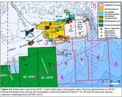
For the 31 selected calibration wells, temperature, maturation and pressure data were derived to generate well and composite regional burial curves for temperature, maturation (vitrinite reflectance, Ro) and pressure (Figure 4.2). Maturation history and potential expelled hydrocarbons were calculated utilizing input parameters for each source rock interval (age, TOC, kerogen type, initial hydrogen index, thickness) (OETR, 2011; Plate 7-3-1-3a). Incorporating these data and results into the Temis™ 2D and 3D modelling programs generated the transformation ratio (TR) through time for selected source rock and play intervals for the entire Scotian Basin (TR is defined as the observed versus initial hydrogen index; it differs for various kerogen types) (OETR, 2011, Plate 7-3-1-3b). This is representative of the maturation level of a given kerogen (SR) as opposed to vitrinite reflectance (Ro) which is indicative of absolute maturity irrespective of kerogen type.
The Temis™ 3D maturity / expulsion modelling was run for the entire Scotian Basin and covers the six PFA-defined play / modelling zones. An important note is that for all source rock intervals, the Age and Evolution of Maturation figures are modelled at a location defined by a thick depocentre between the Chebucto K-20 and Annapolis G-24 wells near the northeastern corner of Parcel 4. As shown in the relevant figures (below), all Parcels fall within the defined modelling Zones 3, 4 and 6, but wells are present only in Zone 3 and include a number of key Temis™ calibration and PFA “Bible” reference wells (Table 4)
|
Well |
NS16-1 Parcel |
Temis Zone |
Temis Well |
‘Bible’ Well |
Comments |
|---|---|---|---|---|---|
|
Annapolis B-24 |
4 |
3 |
- |
- |
Northern part of Parcel 4 |
|
Annapolis G-24 |
4 |
3 |
X |
X |
Northern part of Parcel 4 |
|
Balvenie B-79 |
- |
3 |
X |
X |
West of Parcel 4 |
|
Chebucto K-90 |
3 |
3 |
- |
X |
Adjacent to Parcels 1, 3 & 4 |
|
Crimson F-81 |
4 |
3 |
X |
X |
Northern part of Parcel 4 |
|
Eagle D-21 |
1 |
3 |
- |
- |
- |
|
Primrose 1aA-41 |
- |
3 |
- |
- |
Adjacent to Parcel 2 |
|
Primrose A-41 |
- |
3 |
- |
- |
Adjacent to Parcel 2 |
|
Primrose F-41 |
- |
3 |
- |
- |
Adjacent to Parcel 2 |
|
Primrose N-50 |
- |
3 |
- |
- |
Adjacent to Parcel 2 |
|
Triumph P-50 |
- |
3 |
- |
- |
Adjacent to Parcel 3 |
|
West Chebucto K-20 |
3 |
3 |
- |
- |
- |
Table 4: Key wells within and adjacent to the NS 16-1 Call for Bids parcels and Temis™ 3D maturity / expulsion modelling zones.
The following section reviews the results of the Temis™ 3D maturation / expulsion modelling and summarizes the characteristics of the source rock intervals in the Call region starting with Callovian interval and moving higher stratigraphically to the Tithonian, Berriasian-Valanginian, and Aptian. The Early Jurassic Toarcian-Pleinsbachian interval is very deeply buried in the Call region with modelling indicating it long ago reached maturity and expelled all its hydrocarbons and thus is not discussed. This is also pertinent to the speculative Late Triassic source interval that was not modelled.
In this Call area there are three wells in the deep water region on its western side with the remainder undrilled. The uneven distribution of wells and limited source rock penetrations reduce confidence of modelling results and predicative abilities, especially when extrapolated into deep water areas (OETR, 2011). This is a valid comment for the deep water region as a whole since it comprises about 50% of the entire PFA study area. Modelling thus requires defining and mapping of regional seismic horizons from the shelf and projected into large regions with no well and limited seismic control.
Changes in the vertical position of regional seismic markers and lateral facies changes have a significant influence on the determination of a source rock’s presence, character and expulsion potential. This is especially true for seismically hard to define Jurassic age source intervals in deep water with no well control. As highlighted in the Overview (above), the PFA modelling used a deeper elevation for the approximate top Jurassic J152 seismic marker with correspondingly earlier and greater maturation of the J152 Tithonian (Mic Mac) and J163 Callovian (Misaine) source rock intervals. These will be remodelled with revised results available in mid-2016.
Middle Jurassic: Callovian marine MFS
Misaine Member, Abenaki Formation
Dominantly GAS, Minor OIL
The Misaine Member is widespread across the Scotian Basin and is particularly well developed as a seismic marker (J163) where it is bound above below and above by the platformal limestones of the Scatarie (Bajocian-Bathonian) and Baccaro (Oxfordian-Tithonian) members respectively. Like the potential Early Jurassic source interval, the presence of underlying basement structural elements during its time of deposition would have exerted an influence on its formation though to a lesser degree. It is not penetrated in any of the wells in the NS16-1 parcels.
The Misaine J163 is a mappable horizon in Parcels 1 and 3 though loses its character nearing the current shelf break. This roughly follows the northeast-southwest orientated fault trend that bounds the north of the Chebucto, Triumph (Parcel 3) and Glenelg fields where the interval is deeply buried. Though at similar depths in Parcels 4, 5 and 6 it can be visualized in the condensed successions in ultradeep water beyond them and projected into the salt province where it appears as an isolated reflector.
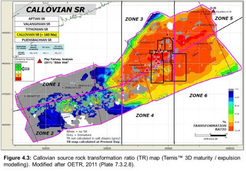
Based on Temis™ modelling centred on a thick depocentre between the Chebucto K-90 and Annapolis G-24 wells (northeastern corner of Parcel 4), it is predicted to be near to fully mature in the Call region (Figure 4.3). The source rock first reached maturity (TR>10%) at about 132 Ma (OETR, 2011, Plate 7.3.2.9a). The highest TRs are in the deep water area where complete maturation (95%) is modelled to occur at about 115 Ma (Aptian) time. In the southern halves of the slope Parcels 4, 5 and 6 the presence of salt canopies compromised the predictive modelling. Yet on their flanks and in the Balvenie area to the west the modelling infers a later peak maturation ranging from Late Cretaceous (~100 Ma) to mid-Tertiary (~30 Ma). Expulsion of hydrocarbons was modelled as rather limited in intensity with gas being the dominant product (OETR, 2011, Plate 7.3.2.9b).
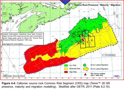
The Misaine’s CRS map (Figure 4.4) reveals a low risk for source rock presence and associated maturation and migration over Call Parcels 1-3 on the shelf. Migration is directed basinward with short distance migration confined to Parcels 2 and 3, and the top portions of Parcels 4 and 5. In Parcel 4 an area of moderate risk extends into Parcel 3 with a similar low risk area dropping into the centre of Parcel 4. The rationale for this is unknown. Nevertheless, in Parcels 1 and 2 vertical migration along listric faults and surrounding salt structures is possible provided they existed during the period of maturation. Better potential / lower risk could exist in the southern regions of the deep water Parcels 4-6 within the salt province where maturation is not complete.
It is acknowledged that due to limited data in deep water and areas with higher elevation salt bodies, an accurate estimate of the Misaine’s potential is uncertain so Temis™ results in the salt province were incomplete (OETR, 2011). Since the Misaine is younger than the Argo salt (by ~25 Ma), it is possible the succession could have been structurally elevated in the Late Jurassic-Early Cretaceous thus interrupting and/or delaying its maturation and subsequent migration of produced hydrocarbons. If so, new modelling based on revised seismic interpretations (this report) could have significant implications regarding the Misaine’s modelled generative and upside potential. Nevertheless, as currently known and modelled, the Misaine Member is not believed to be a significant contributor to the NS16-1 parcels’ petroleum endowment.
Late Jurassic: Tithonian carbonate to deltaic transition MFS
Abenaki / Upper Mic Mac to Lower Member Missisauga formations
Dominantly OIL & GAS
Modelling of this source interval in the PFA (OETR, 2011), together with extant geochemical assessments, confirm the Tithonian as the most significant contributor to the Scotian Basin’s hydrocarbon endowment. As described above, it represents deposition in a transitional setting from a carbonate-dominated marine (Abenaki) to siliciclastic fluvial-deltaic (Mic Mac / Missisauga) environment. The source interval lithologies have an average TOC of about 3% composed of mixed Type IIA/IIB-III kerogens capable of generating gas, condensate, and oil (Mukhopadhyay and Wade, 1990). The deposition of this source is regional in scope centred in the central and eastern parts of the Scotian Basin. The Tithonian source rock interval has not been penetrated in any of the wells within and adjacent to the NS16-1 parcels.
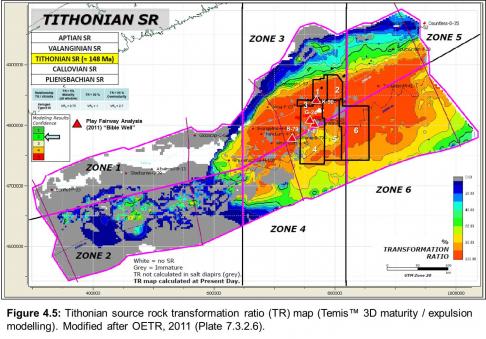
Temis™ modelling indicates that the Tithonian interval has high TRs in the 80-100% range. This is similar to the underlying Misaine Member with the majority of hydrocarbons expelled over time in Zones 3, 5 and 6, and less so in Zone 4 (Figure 4.5). Expulsion (TR=5%) began at about 132 Ma in the Valanginian with the succession being rapidly buried with the maximum (TR=95%) at about 113 Ma in the Aptian-Albian (OETR, 2011; Plate 7-3-2-7a). Significantly later maturation east and west of Parcels 4 (Balvenie B-79) and 6 occurred during the Upper Cretaceous to Paleogene. Beyond the Crimson F-81 and Annapolis G-24 wells no results are presented that may be due to the presence of allochthonous salt tongues and canopies. Though lacking data, the modelled lower maturity trend could suggest the source interval here is still within the maturation window, and maturation could charge salt-related trapping architectures formed during the Early Cretaceous and later.
The Tithonian’s oil mass fraction (ratio of oil versus total hydrocarbons) in the Call region parcels is calculated to be low to moderate (20-40%) due to the source rock’s lithologies and gas-prone kerogens, and, greater depth of burial with associated secondary cracking (OETR, 2011; Plate 7-3-2-7b). However, where it is shallower and less mature such as the basin margins (Parcels 1 and 2) and deep water (Parcels 4-6), the oil fraction may approach 60% in places.
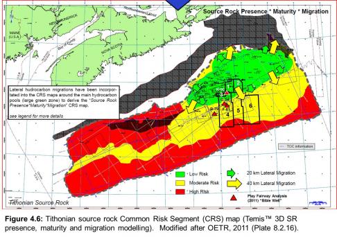
The CRS source rock maps for the Tithonian indicate highest potential (lowest risk) is in Parcels 1-3 with moderate risk in Parcels 4-6 (Figure 4.6). There is low risk for short (20 km) distance migration in the shelf parcels with moderate risk in the slope portion. However, as stated previously, the depth of this interval was overstated by at least a kilometer during this model iteration (2011). New seismic mapping and Temis™ modelling will no doubt improve the probability of its presence and oil and gas generative potential, especially within the salt province.
Early Cretaceous: Berriasian-Valanginian deltaic MFS
Lower Missisauga Formation
Dominantly GAS
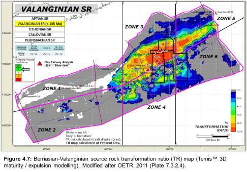
Like the younger Aptian age Misaine Member, this source interval’s distribution is centred in the Sable Subbasin, the depocentre for the Missisauga Formation, and is absent in the western Scotian Basin. The Berriasian-Valanginian (“Valanginian”) is composed of a number of thin MFS shales within an up to 200 m thick transitional marine-outer deltaic facies with a low TOC (~1%) composed of Type III gas-prone kerogens. In the western and northwestern parts of the Subbasin it was deposited in a carbonate-dominated marine setting adjacent / proximal to the Abenaki (Baccaro Member) carbonate bank margin. In the central part basal Missisauga / top Mic Mac siliciclastic fluvial-deltaic environments dominated, and to the east a mixed carbonate-siliciclastic shelf setting. Specific source interval lithologies have an average TOC of about 3% composed of mixed Type IIA/IIB-III kerogens capable of generating gas, condensate, and oil (Mukhopadhyay and Wade, 1990) however the overall succession has a lower TOC averaging about 1% (OETR, 2011).
Centred on the depocentre between the Annapolis and Chebucto well, Temis™ modelling (Figure 4.7) predicts the source rock entered the maturation window (TR=5) at about 130 Ma (Hauterivian) not long after deposition (136 Ma). Rapid sedimentation in this delta-marine transitional setting quickly buried these rocks with complete maturity (TR=95) reached at about 110 Ma (Early Albian). However, outside of this small area the Valanginian has not reached complete maturity with entry into the maturation window more recent ranging from Upper Cretaceous to Upper Paleocene (OETR, 2011; Plate 7.3.2.5a). The source`s modelled expulsion and oil mas fraction distribution likewise follows the northeast-southwest strike of the Missisauga`s delta-marine transition. There is a significant level of expulsion (60-80%) in the regions covered by Parcels 1-3 and northern haves of Parcels 4-6 but with a very low oil mass fraction of about 10% together as a consequence of its dominantly Type III kerogens (OETR, 2011; Plate 7.3.2.5b). In the southern parts of the deep water parcels the TR ranges are highly variable (0-70%) with the pattern inferring the influence of large salt features on sediment deposition and maturation.
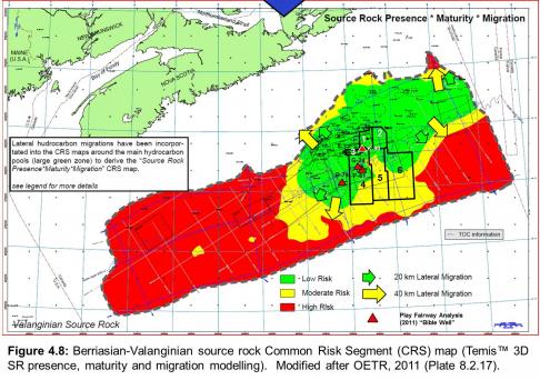
The Valanginian CRS maps for this source rock interval reflect the Lower Missisauga Formation’s probable distribution. Call Parcels 1-3 and large portions of Parcels 4 and 5 have a low risk for this source rock’s presence and maturation with associated short (20 km) lateral migration. The remainder of the latter parcels and Parcel 5 have moderate risk of its presence (Figure 4.8). Vertical migration is possible up listric faults or along the flanks of salt piercement features. However, the dispersed nature of potential source intervals in the succession and dominance of Type III / low HI kerogens indicate that it has only a poor to fair potential and any hydrocarbons produced would be gas.
Early Cretaceous: Intra-Aptian deltaic MFS
Naskapi Member, Logan Canyon Formation
Dominantly GAS, Minor OIL
The Aptian MFS source rock interval is present across most of the Scotian basin save for its northern margin. On the shelf, the Naskapi is positioned high in the stratigraphic section, and as a transgressive succession at the base of the Logan Canyon Formation separates the overlying Cree Member from the Missisauga Formation. It is hard to discern within the shale-dominated slope region though can be identified biostratigraphically.
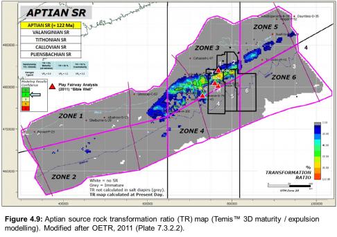
The Naskapi Temis™ transformation ratio (TR) map indicates it is immature except within a narrow northeast-southwest trending band in the Sable Subbasin where it is more deeply buried (Figure 4.9). This band transects the northern parts of Parcels 4-5 and southern parts of Parcels 2-3. The locus of deposition (as mapped in 2011) is in the thick depocentre between the Annapolis G-25 and Chebucto K-90 wells. Here and along trend the sediments entered the maturation window (TR=5%) at about 108 Ma (Albian) and were rapidly buried into the Late Cretaceous (OETR, 2011; Plate 7-3-2-3a). In these local troughs the TR locally exceeds 80% but outside of this band the almost all the Naskapi is modelled as immature (TR<5%) and never reaching fully maturity. The Naskapi’s oil mass fraction is modelled to be low to moderate (30-50%) though is known as being mostly gas-prone (OETR, 2011; Plate 7-3-2-3b). Likewise it has very limited expulsion over a very small area following the outer shelf margin band.
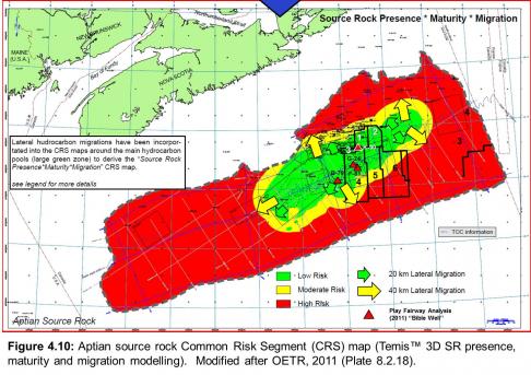
The Common Risk Segment (CRS) maps (Figure 4.10) show high probability / low risk for the Naskapi source rock existing within the Sable Subbasin with associated low risk for short (20 km) lateral migration. This region covers all of Parcels 1-3 and most of 4-5, with Parcel 6 having low risk to the northwest and high risk in its southern deeper portions. It is unlikely that any potential exists in the deep water slope though small isolated pockets within salt minibasins could be present though with limited generative capacity for mostly gas. The Naskapi is thus considered as a minor gas-prone source rock in the NS16-1 parcels.
Hydrocarbons
The Scotian Basin is primarily gas-prone based on the great volume of source rock successions that had significant input from deltaic depositional systems. Most discoveries and production were of gas with associated condensates, yet there are a number of significant oil shows and discoveries, and previous oil production. For the wells in the NS16-1 Call region, these are tabulated in Table 4.2.
Since the late 1970s, researchers have undertaken analyses of these liquids in order to classify them and derive information related information on maturation and source rock relationships. Powell and Snowdon (1979) defined three oil and condensate families source predominantly by terrestrially dominated deltaic and marine shales of the Mic Mac, Missisauga and Verrill Canyon formations. In the 1990s, P.K. Mukhopadhyay undertook a comprehensive study of Scotian Basin hydrocarbon and source rock characterizations and relationships in association with the Geological Survey of Canada with a number of important papers and research contributions published. Mukhopadhyay et al. (1995), using cluster analysis of polyaromatic compounds, defined two oil families. Group I is comprised of high maturity condensates and associated gas derived from a terrestrial source (Type IIB/III kerogens). Group II oils from the Cohasset-Panuke-Balmoral fields suggest a marine source generated from mixed organic matter types (Type IIA/III kerogens).
In a geochemical analysis of oils and condensates from the Sable Subbasin, Illich et al. (1999) defined five oil families (three larger groupings). Two Families, A and B, were determined to have been generated from terrestrial type (III) organic matter from two closely related sources. The third, Family C, may represent the products of oil mixing since they have geochemical compositions indicative of terrestrial (Type III prodeltaic) and marine (Type II, carbonate-rich) source rocks. The remaining oils were grouped into two catch-all families, D and E. These contain very mature oils, some with unique compositions, and others that might be contaminated with drilling additives. They all have slightly different maturities that could represent separate source intervals. A Family D oil from the Venture D-23 well (4889m, DST No.4, 6-Upper Sand, Missisauga Fm.*) contained an above background level of gammacerane though the source rock and its age is unknown, but could be from an older, Early Jurassic source. (* Note: Illich et al. (1999) do not indicate the formation and DST number, and the 4771 m sample depth is incorrect.)
Fowler and Obermajer (2001) defined three families of liquid hydrocarbons (1, 2 and 3a / 3b) in the Scotian Basin. Each has characteristic properties, maturation profiles and geographic separation suggesting they came from separate source rocks, with most sourced from terrestrially-derived organic matter (Type II-III). The high gravity (47-55 API) oils from the Cohasset, Panuke, Balmoral, and Penobscot fields are from Family 1 and are probably the least mature. Family 2 oils are found in the Arcadia, Banquereau, Glenelg and North Triumph shelf-edge fields in the Sable Subbasin and were generated from rocks with greater levels of higher land plant material than the others, or, that they are less mature. Family 3 oils may be due to a mixture of the Family 1 and 2 oils. Since Family 1 oils are only found in the Cohasset area on the west side of the Sable Subbasin, and Family 2 in the North Triumph area in the south, this significant geographic separation supports the interpretation that they are from different sources. This study indicated that the Scotian basin oils and condensates had Ro equivalents of between 0.7 and 0.94% confirming they were generated in the central part of the oil window.


