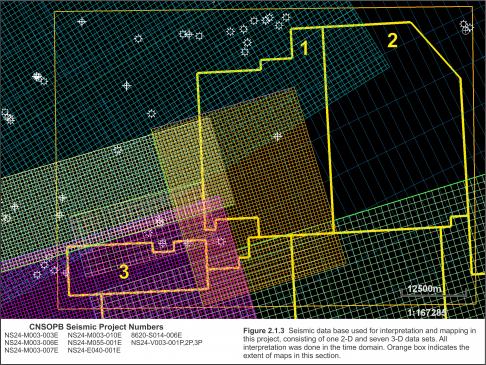
Parcel 2 is covered only by sparse digital seismic profiles and contains no wells. Although two 3D seismic survey outlines extend over the Parcel, there is no subsurface coverage (Figure 2.1.3). The 1983 vintage 2D seismic used in this mapping project, indicated by the blue lines, has 2 km dip and 8 km strike spacing. Husky Oil acquired 2D seismic over this area in the mid-1980s and identified a number of leads. This data set was not available in digital format for this interpretation but would greatly improve the resolution of the mapping.
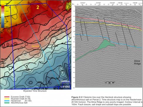
The Primrose oil and gas discovery is located 7 km east of the block. Shell’s Primrose N-50 well (1972) was one of the first exploration successes in the Scotian Basin and was drilled in 91 m (298 ft) of water to test a shallow salt diaper (Figure 2.3.1). It was terminated at 1713 m (6052 ft) bottoming in Argo salts. Significant hydrocarbon pay was present and tested in Wyandot (gas and condensate), Logan Canyon (gas and condensate) and Iroquois (oil and gas) formations (Table 2.7). Refer to Smith et al. (2014) for a more comprehensive re-evaluation of the Primrose field including an updated resource assessment.
|
Zone1 |
Formation |
Top (m MD) |
Base (m MD) |
Gross Thickness (m TVD) |
Net Pay Thickness (m TVD) |
Net Pay Porosity (Average) |
Sw (Average) |
|---|---|---|---|---|---|---|---|
|
1 (gas)2 |
Wyandot |
1356.4 |
1446.0 |
89.6 |
42.9 |
0.229 |
0.35 |
|
2 (gas)3 |
Logan Canyon |
1497.9 |
1571.3 |
73.3 |
12.6 |
0.227 |
0.32 |
|
3 (gas) 3 |
Iroquois |
1608.5 |
1642.9 |
34.4 |
4.3 |
0.161 |
0.52 |
|
3 (oil) 3 |
Iroquois |
1642.9 |
1657.4 |
14.5 |
4.6 |
0.155 |
0.47 |
|
1 Zones: Defined by the CNSOPB 2 Zone 1 Cut-offs: PHI ≥ 0.16, Vsh ≤ 0.40, Sw ≤ 0.60 (PHI=0.16 equivalent to 0.1 MD permeability) 3 Zones 2 & 3 Cut-offs: PHI ≥ 0.10, Vsh ≤ 0.40, Sw ≤ 0.60 |
|||||||
Table 2.7 Log-defined hydrocarbon zones in the Shell Primrose N-50 well (Smith et al., 2014).


