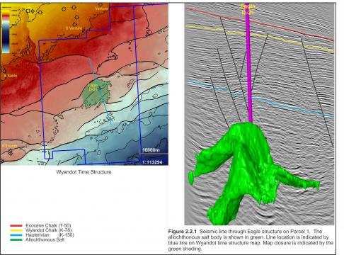
Parcel 1 includes the Eagle D-21 gas discovery in the central portion of the Sable Subbasin with current water depths varying from 20 m to 170 m, and most of the block in less than 100 m. Eagle is the only well that has been drilled on this parcel (Figure 2.2.1).
In the early 1970s, Shell Canada acquired a large offshore acreage position, which included the Eagle area, and acquired 2D seismic which was used to define the Eagle prospect. The Shell et al. Eagle D-21 well was spudded on April 22, 1972 approximately 22 km southeast of Sable Island in 51 m of water. The well reached a total depth of 4660 m in the early Cretaceous lower Missisauga Formation encountering 52 m of net gas pay in the late Cretaceous chalk of the Wyandot Formation. Gas was recovered from all three well tests.
In July, 1999 Mobil Oil Canada partnered with Shell Canada and Imperial Oil to acquire a number of exploration licences in the Sable Subbasin that included the Eagle discovery. The partnership acquired seismic data over a number of their licences, including the northern portion of the current Eagle block. In 2002, following the merger between Exxon and Mobil, ExxonMobil and partners Shell and Imperial acquired 700 km2 of 3D seismic over the Eagle discovery and large portion of Parcel 1. In July, 2004 ExxonMobil’s Exploration Licence, a portion of which covered Eagle, expired and the land reverted to crown.
As a result of the NS07-1 Call for Bids, a licence including the Eagle field was awarded to Ammonite Corporation under a “promote license” scenario where the 25% work deposit was deferred for three years. Ammonite returned the parcel to Crown on December 31, 2012 with no deposit being paid.


