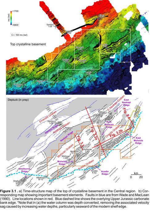
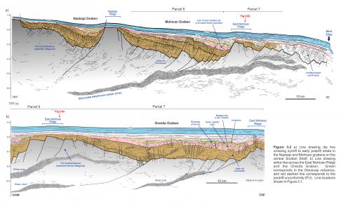
The LaHave Platform along the Central region of the Scotian margin is broken by a complex arrangement of faults that offset Early Paleozoic crystalline basement and produce synrift depocentres separated by basement highs (Welsink et al. 1989; Wade and MacLean, 1990). The dominant structural grain is northeast-southwest, and most faults (both major border faults and minor intrabasinal faults) dip landward, towards the northwest. Many of the border faults sole into landward dipping to sub-horizontal mid-crustal detachments or shear zones (e.g. Figure 3.2; Welsink et al. 1989), similar to several other rift basins of the Newark Supergroup (e.g. Manspeizer, 1988). On reflection seismic profiles, these produce horizontal to steeply inclined highly reflective intervals within the crust that can commonly be correlated over distances of many tens of kilometres. Although the typical absence of a strong, consistent impedance contrast between crystalline basement and overlying synrift strata makes correlation of a ‘top basement’ surface challenging, careful mapping guided by some of the better quality surveys provides a clearer view of a number of basement elements that are defined below (Figure 3.1).
The Naskapi Ridge is the most prominent basement element in the Central region. It forms a 4 to 22 km wide northeast-trending flat-topped basement high composed of Early Paleozoic rocks with little or no internal reflectivity. It can be followed easily along strike over a distance of 160 km. Its southwestern end terminates where it plunges sharply to the southwest into a poorly defined (crossed by only 3 seismic profiles) but deep rift basin (up to 1.6 sec twt). Its northeastern end is narrow and is heavily faulted near Ojibwa E-07, where its trajectory curves slightly to the north over its final 20 km. Here it separates faults that dip landward from those that dip seaward in what appears to be an important relay or accommodation/transfer zone. The northern edge of the Naskapi Ridge was penetrated by Naskapi N-30, which encountered Paleozoic metasedimentary rocks that probably correspond to the Meguma Supergroup (Pe-Piper and Jansa 1999). The northeastern termination of the horst block was penetrated at Ojibway E-07, which encountered Middle Paleozoic granites. Similar granites widely intrude Meguma metasedimentary rocks on mainland Nova Scotia (Jansa and Pe-Piper 1999). Unlike the Yarmouth Arch, there is no distinct or consistent magnetic response across most of the Naskapi Ridge (Figure 2.8).
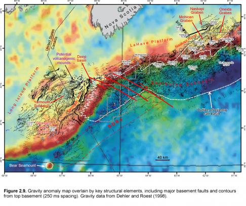
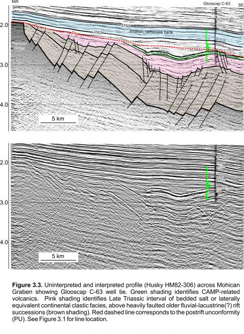
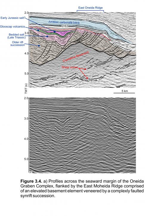
The Naskapi Ridge separates the Naskapi Graben to the north from the Mohican Graben to the south (Figures 3.1, 3.2, 3.3). Its northern edge corresponds to the main landward (northwest) dipping border fault(s) of the Naskapi Graben. Its southern flank is also offset by dominantly landward dipping fault (Figure 3.3). The faulted top basement surface plunges to the southeast, away from the Naskapi Ridge, until it intersects the northwest dipping border faults that flank other basement highs like the Moheida Ridge (Figure 3.1). The Moheida Ridge and the East Moheida Ridge that is offset from it (right-lateral) are structurally much more complicated than the Naskapi Ridge. They do not consist of a single basement element, but are instead characterized by a complex jumble of faulted basement blocks and synrift strata that are challenging to unravel. Figure 3.4 from the Blueberry 3D survey (CNSOPB program number NS24-E043-004E) crosses the eastern parts of the East Moheida Ridge. It shows that the ridge is cored by an elevated basement element, but clear synrift strata within a series of rotated fault blocks overlie this elevated basement element. A similar situation exists near Glooscap C-63, Moheida P-15, and Mohican I-100 that were all drilled above or off the flanks of the Moheida Ridge (Figure 3.1). Each of these wells bottomed in younger rift successions that veneer more heavily faulted older (and unpenetrated) rift intervals of unknown composition or age. It is unlikely that early synrift deposits would have accumulated above topographically elevated basement blocks, thus we infer that the Moheida and East Moheida Ridges were developed sometime after rift extension and associated sedimentation had already begun. Such features could represent inversion structures. The Acadia Ridge and Shelburne Ridge have a similar character. On gravity data, the Moheida and East Moheida ridges align with very strong positive anomalies that are commonly found along the shelf edge (Figure 2.9; Keen et al. 1990). The Acadia and Shelburne ridges, located seaward of the shelf-edge anomaly, also produce an elevated gravity response.
In contrast to the common northeast-southwest grain of most basement elements, the East Mohican Ridge trends normal to this orientation. It consists of an arcuate basement element that is roughly perpendicular to the Naskapi and Moheida/East Moheida ridges. Both the dip and strike profiles in Figure 3.2 cross this important basement element, showing that synrift strata both thin and are heavily eroded across it. The East Mohican Ridge produces a moderately strong positive gravity anomaly (Figure 2.9). Basement depth increases abruptly to its west, across one or more prominent basement faults with a total throw of at least 1.5 sec (twt). These faults define the eastern boundary of the Mohican Graben. The eastern flank of this high plunges more gradually beneath the Oneida Graben (Figures 3.1, 3.2b). The East Mohican Ridge aligns with right lateral offsets observed between Moheida and East Moheida ridges (at its southern termination) and the Naskapi and East Naskapi ridges (at its northern termination; where there is a clear relay ramp). This implies that the East Mohican Ridge developed along a right-lateral transfer zone.


