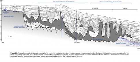
Parcels 1 and 2 are located entirely on the slope in water depths ranging from approximately 1050 to 3100 m and above the primary salt basin that lies seaward of the Yarmouth Arch. The Shelburne Delta is located immediately landward (northwest) of these parcels. Numerous complex salt diapirs and walls, expelled in the Jurassic to mid-Cenozoic, can be found in the landward parts of Parcels 1 and 2. In contrast, the Middle to Late Jurassic Shelburne Canopy occupies the seaward parts of these parcels (Figure 2.6). No wells have been drilled in either parcel, but numerous hydrocarbon trap configurations are possible. Traps may include salt-cored folds, three-way closures on salt flanks, and traps associated with turbidite sands beneath, and sealed by, the Shelburne Canopy as it advanced seaward. Turbidite sands derived from the Shelburne Delta are the most likely reservoirs. Tentative correlation into Cost G-2 and Mohawk B-93 implies that progradation of the Shelburne Delta began in the Middle Jurassic (above the J163 marker), with numerous regressive-transgressive cycles recognized up into strata as young as Late Cretaceous. The best developed delta clinoforms are found in Cretaceous strata above the J150 marker (Figure 2.14), particularly beneath the northeastern parts of Georges Bank (Figure 2.13). As such, the most reservoir prone intervals in Parcels 1 and 2, immediately downslope of the Shelburne Delta, are probably Cretaceous.
Further north, Parcels 3 and 4 are located on the outer shelf and upper slope in water depths ranging from approximately 100 to 1700 m. The landward parts of these parcels are positioned above the Mohawk Graben Complex, in an area with poor seismic coverage. The grabens form narrow but deep (up to 1.4 sec twt) basins presumed to contain synrift fluvial-lacustrine strata equivalent to the Eurydice Formation, capped by the J200 surface. The western parts of the Mohican Graben Complex may also contain salt (western half of Parcel 3), but detailed mapping is not possible here. Above the Mohawk Graben Complex, the Middle to Late Jurassic and earliest Cretaceous succession is characterized by mixed carbonates and clastics that were deposited above the Mohawk Graben Complex. Bonnet P-23 is the only test of the Middle to Upper Jurassic carbonate bank west of Albatross, more than 150 km away. It was drilled about 6 km back from the highly faulted reef margin and encountered a variety of lithologies in the Baccaro: shaly limestones, dolomites and dolomitic limestones. Near the base of the Baccaro a number of thick dolomite intervals were penetrated with good porosities and loss circulation zones, but no hydrocarbons were encountered, possibly due to lack of fault seal. The northern edge of the Barrington 3D survey extends onto the outer parts of the carbonate bank (Figure 2.12), where local carbonate build-ups are recognized in the eastern part of Parcel 3. One of these has very bright amplitudes which could signal porosity development, hydrocarbon charge, or both. Other portions of the bank edge show rim development, but the lack of 3D seismic makes these difficult to map.
In addition to carbonates, Middle to Upper Jurassic siliciclastic reservoirs are also possible in these parcels. Mohawk B-93 encountered a 505 m thick texturally mature sand-dominated Upper Jurassic succession, of which 194 m were porous sands averaging 23% porosity (Given, 1977). Although it is not possible with the existing dataset to delimit any traps in the landward parts of Parcels 3 and 4, acquisition of modern 3D seismic volumes may reveal new closures associated with compaction above basement horst blocks or even fault blocks within the synrift succession, in addition to potential carbonate-related targets.
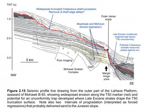
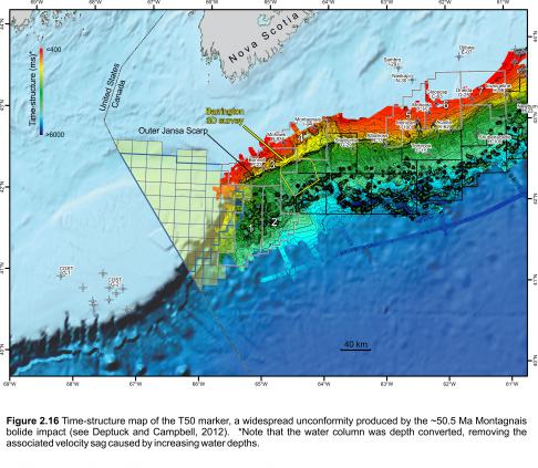
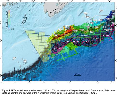
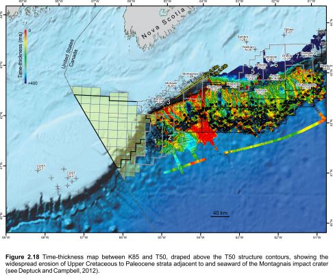
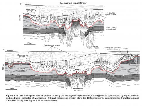
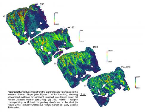
Significant portions of Parcels 3 and 4 are located seaward of the margin hinge zone (and carbonate bank edge) and within the ‘slope detachment province’ described by Deptuck (2011a) (Figures 2.12, 2.13). Seismic profiles indicate that the texturally mature sand-dominated Upper Jurassic succession at Mohawk B-93 correlates seaward into the topsets of a Callovian or Oxfordian shelf-edge delta (forced regression - Figure 2.15) in what must have been a gap in the carbonate bank. The eastern parts of the Shelburne Delta may also have extended onto Parcels 3 and 4. Widespread erosion of Cretaceous shelf strata during the Montagnais marine impact event, however, has removed the outer shelf succession east of the most obvious Cretaceous Shelburne Delta clinoforms (e.g. Figures 2.15, 2.16, 2.17, 2.18, 2.19) (see also Deptuck and Campbell 2012). That the Middle to Upper Jurassic and potentially even Cretaceous shelf-edge deltas delivered sand to the slope in Parcels 3 and 4 is supported by time-thickness maps in deepwater and amplitude extractions from the Barrington 3D survey (Figure 2.20). These extractions show clear evidence for submarine channel systems in Jurassic, Cretaceous and Tertiary strata, indicating that multiple turbidite reservoir intervals are possible off southwestern Nova Scotia.
Potential reservoirs could have been incorporated into a number of structural and stratigraphic traps. Potential structural traps involve Jurassic to Earliest Cretaceous strata rotated and detached as rafts above the autochthonous salt layer, and their raised edges may locally form traps draped by younger Cretaceous strata. The most promising targets, however, are stratigraphic traps in the seaward parts of Parcel 3 and 4 where turbidites onlap the slope or where turbidite sands were truncated by the T50 unconformity and later draped by widespread Eocene mudstones, creating unconformity traps (e.g. Figure 2.15).
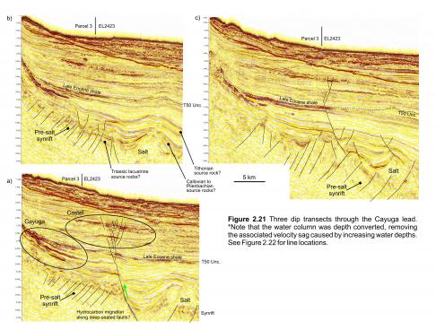
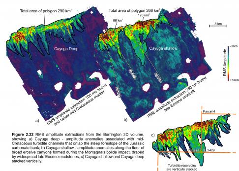
One potential stratigraphic trap is the Cayuga lead captured in the Barrington 3D survey (Figures 2.21, 2.22). It consists of a series of mid-Cretaceous to Early Eocene amplitude anomalies interpreted to correspond to turbidite channel reservoirs contained within a combination up-slope pinch-out and angular unconformity trap. Cayuga is found immediately down-slope from the eroded carbonate bank edge (‘outer Jansa Scarp’ of Deptuck and Campbell, 2012), partly overlapping Shell’s exploration licenses 2423 and 2429. Two main intervals produce anomalous amplitudes that terminate up-slope and down-slope. Amplitude extractions from the lower interval show a clear network of channels converging down-slope into trunk channels. The associated amplitude anomaly covers an area of about 290 km2 and terminates where it onlaps the steep foreslope of the Jurassic carbonate bank (Figures 2.21, 2.22a). Amplitude extractions from the upper interval show a much broader anomaly that appears to correspond to the floor of very wide latest Cretaceous or earliest Cenozoic canyons sculpted by the Early Eocene T50 unconformity (Figure 2.22b). This amplitude anomaly could also correspond to massive reservoir units deposited during the ~50.5 Ma Montagnais impact event, or shortly after from turbulent flows carrying better sorted sand down the slope as water resurged back towards the crater cavity shortly after the initial marine impact event (see Deptuck and Campbell, 2012). The associated amplitude anomaly covers an area of about 266 km2. Both of these amplitude anomalies stack vertically, producing a potentially very large stratigraphic trap.
A key element of this trap is the widespread Montagnais erosion surface that produces an angular unconformity all along the Outer Jansa Scarp (e.g. Figures 2.15, 2.16). This angular unconformity was subsequently draped by widespread Late Eocene mudstones (Late Eocene mudbelt/sub-unit 1c of Deptuck and Campbell, 2012), producing an important regional seal. Although there appears to be up-slope pinch-out or onlap of several of the deeper Cretaceous turbidite channels mentioned above, the presence of the angular unconformity and later regional seal reduces the risk of up-slope leakage along channels that could compromise the integrity of the stratigraphic trap. The Cayuga lead could be analogous to the Buzzard field in the North Sea, which contains 400 million barrels of oil in Late Jurassic reservoirs that form a wedge-shaped stratigraphic trap thinning onto the slope (Dore and Robbins 2005). The Jubilee discovery of Ghana containing stacked Turonian turbidites (95 m of pay; ~700 mmboe recoverable) may also be an appropriate analogue.
Numerous similar amplitude anomalies are recognized on 2D seismic profiles both west and east of the Barrington 3D survey in Parcels 3 and 4, as well as seaward into Parcels 1 and 2 where they onlap salt structures, implying that potential turbidite onlap traps could be widespread. In addition, shallower stratigraphic traps associated with younger Cenozoic turbidites that onlap the steep slope are also possible, and a wide variety of amplitude anomalies that could be DHIs are present in Parcels 1 to 4 (e.g. Castel lead identified in Figure 2.21). As Torbrook C-15 has shown, however, some of the shallowest amplitude anomalies could correspond to poorly consolidated low-velocity siltstones (Kidston et al., 2007).


