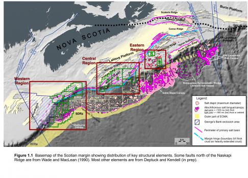
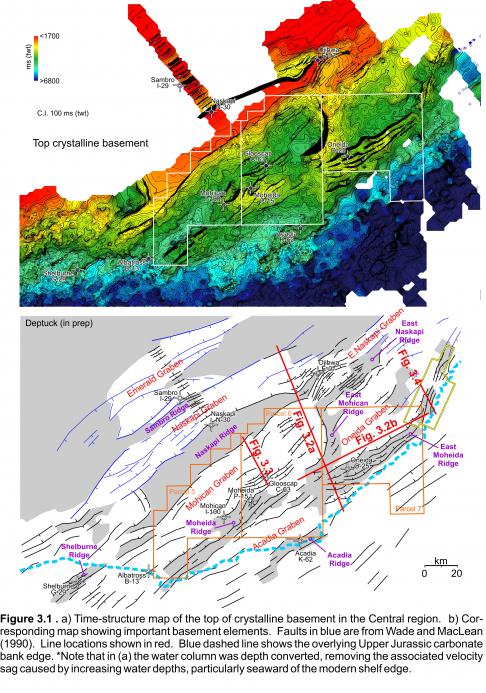
Parcels 5, 6, and 7 are located on the outer shelf and upper slope of the central Scotian margin, extending into 1580, 840, and 2360 m of water, respectively. The parcels border Shell’s Exploration Licence 2430 and BP’s Exploration Licence 2431. Parcel 5 is located principally above the western part of the Mohican Graben, where widespread detachment of cover strata took place above thicker intervals of synrift salt (as described above). Parcel 6 is located above the eastern part of the Mohican Graben, extending across the Moheida Ridge to the eastern parts of the Acadia Graben (Figure 3.1). Parcel 7 is located mainly above the Oneida Graben, extending across the East Moheida Ridge (Figure 3.1). Both Parcels 5 and 6 are located principally inboard the Jurassic carbonate bank edge, while Parcel 7 extends across the carbonate bank edge and onto the carbonate foreslope (similar to Parcels 3 and 4 in the southwestern region).
Although three wells in the Mohican Graben penetrated the uppermost parts of the synrift succession (Mohican I-100, Moheida P-15, and Glooscap C-63), seismic data indicate that they sample less than 10% of the total rift succession. More broadly, these three wells, combined with Sambro I-29 located 45 km northwest of the Mohican Graben, are the only wells west of the Orpheus Graben (Figure 1.1) to sample synrift strata on the entire Scotian margin. No wells penetrate any of the rift succession in the Oneida or Acadia grabens in Parcels 6 and 7. As such, the hydrocarbon potential of the synrift succession in the Central region, as with elsewhere, is poorly understood and hinges in large part on whether or not synrift lacustrine source rocks could have accumulated in the deeper parts of grabens. Such deposits could have formed during early rift extension when the margin was located at lower paleolatitudes with associated wetter climates more favourable for source rock development (Brown 2014; see also the source rock section below). Kettanah (2011) identified liquid and vaporous hydrocarbons in fluid inclusions within salts of the Late Triassic-Early Jurassic Argo Formation from the Glooscap C-63 and Weymouth A-45 wells. The characteristics of the liquids were determined to be characteristic of “complex, high molecular weight, aromatic or cyclic hydrocarbon compounds higher than methane”. The author commented that given their stratigraphic position, the potential source could have been the underlying sediments of the Norian-Rhaetian Eurydice Formation. It is possible that some of the brighter amplitude continuous reflections contained in the lower, heavily faulted rift succession (described earlier) correspond to a fluvial-lacustrine succession containing potential source rocks. The presence of large interconnected lakes during early rifting could explain why these facies can be correlated between rift grabens in the Central region.
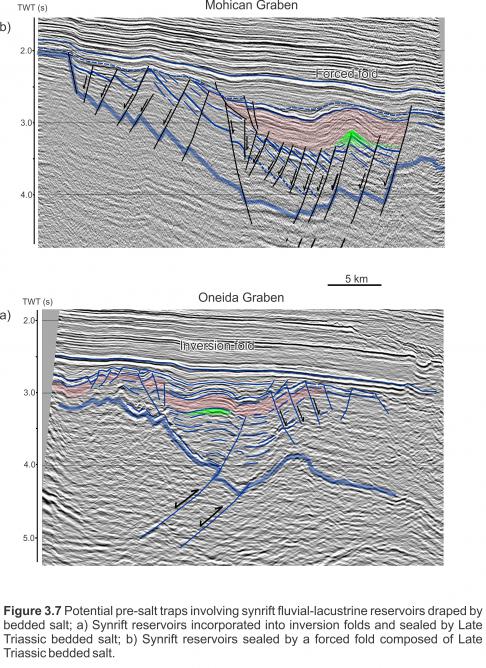
If synrift source rocks are present in the Central region, a wide variety of untested synrift targets may exist in Parcels 5, 6, and 7. The Blueberry 3D survey provides excellent imaging of the synrift succession just east of Parcel 7. It shows the development of widespread inversion structures that could form excellent traps, particularly where they are sealed by Late Triassic salt (Figure 3.7a). Similarly, the bedded salt interval encountered at Glooscap C-63 is widespread, draping underlying rotated faults blocks (Figure 3.7b). In some areas, the bedded salts may form a widespread seal above earlier synrift reservoirs. No wells in this region have tested this pre-salt play concept or the deeper synrift strata. Above this rift succession, the Jurassic carbonate bank may also have additional untested potential, particularly in Parcel 7 which crosses the bank edge. Like Parcels 3 and 4, however, new 3D seismic data-sets will be needed to identify new targets in the Jurassic carbonate bank, as with the underlying complex Triassic rift succession.


