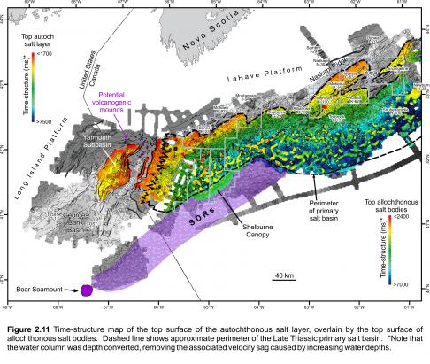
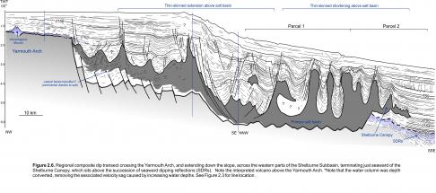
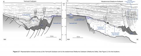
Another primary salt basin lies east of the Yarmouth Arch (Figure 2.11), occupying the western most parts of the Shelburne Subbasin, as defined by Wade and MacLean (1990). The salt basin corresponds, in part, to Shimeld’s (2004) salt province I. Crystalline basement, and the sediments that immediately overlie it, are poorly imaged in this region. This is particularly true along a 10 to 20 km band paralleling the Yarmouth Arch, where strata show subtle discontinuous layering, with poorly defined faults and folds that cause the succession to pinch and swell (Figures 2.6, 2.7). The succession, which is capped by the J200 marker, is interpreted to correspond to Triassic rift deposits, and the undulations to poorly developed salt pillows. Further down the slope there are clear salt pillows, large salt rollers, and even rare salt diapirs, where younger faults increasingly sole out into this salt-bearing interval. Continuing down the slope, evidence for salt rising from a thick primary salt basin is unequivocal, with widespread diapirism and minibasin development (see Shimeld 2004; Deptuck 2011a).
These observations imply there is a lateral change in the dominant lithofacies with increasing distance from the Yarmouth Arch. Immature clastic-dominated Eurydice facies may pass laterally into mixed Eurydice and salt facies, and eventually into more massive salt intervals (Osprey to Argo equivalent) towards the main part of the autochthonous salt basin (landward parts of Parcels 1 and 2; Figure 2.11), where rift and early postrift subsidence were greatest. Similar lithofacies changes are recognized in the Mohican Graben on the central Scotian margin (described in a following section). The western boundary of the primary salt basin is therefore interpreted to be transitional over a 10 to 20 km region adjacent to the Yarmouth Arch (Figure 2.11).
In contrast, the seaward termination of the salt basin is a clear linear structural boundary marked on seismic profiles by an abrupt northeast-trending vertical step that forces inflated autochthonous salt to rise vertically (Deptuck 2011a) (Figure 2.6). This step appears to have formed where seaward dipping reflections (SDRs), presumed to correspond to thick intervals of basaltic lava flows interlayered with volcaniclastics, accumulated during the latest stages of rifting or earliest postrift (Larsen et al. 1994; Keen and Potter 1995; Jackson et al. 2000). In this setting, the volcanics loaded and depressed the seaward edge of the original primary salt basin that separated Nova Scotia from Morocco (Deptuck 2011a). As such, the volcanic wedges may bury parts of the salt basin and underlying continental crust. SDRs have been tracked on seismic profiles from the Bear Seamount, near the southern tip of the Yarmouth Arch, to an interpreted transform fault zone that offsets the seaward edge of the salt basin, roughly 360 km to the northeast (i.e. the Yarmouth Transform – described below).


