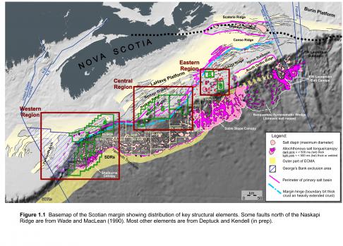
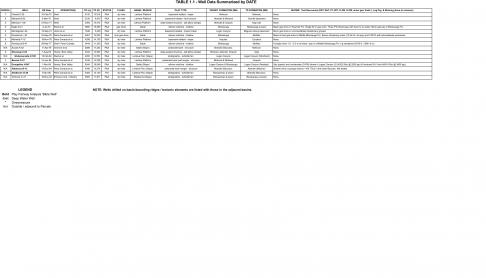
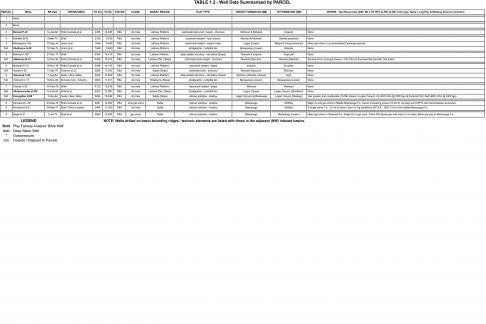
The central part of the Scotian margin has been somewhat better explored than the western area, with four wells included with Parcels 5, 6, and 7 (Figure 1.1, 2.2) and an additional five wells located nearby. The eight wells tested several play types, though they encountered no significant petroleum shows (Tables 1.1 to 1.3 inclusive). (Access .xlsx files here: Table 1.1, Table 1.2, Table 1.3)
In the Central region, exploration began in the late 1960s on the shallow water Scotian Shelf as an extension of the activity around Sable Island to the east. Following a number of seismic programs, five wells were drilled in the 1970s to early 1980s to test structural plays. A sixth well tested a shallow rollover anticline in the mid-1980s, and then interest turned to the deep water slope with two wells testing stratigraphic and structural traps. Following extensive, basin-wide regional 2D seismic surveys in the late 1990s, the slope region was licensed by industry though resulting only in a single well drilled in 2003 to test a shallow stratigraphic play. No significant oil and gas shows were encountered in any wells.
Oneida O-25 (1970) was the third well drilled in the Scotian Basin. It was operated by Shell to test a very large (~225+ km2) unfaulted, low relief simple anticlinal closure on the LaHave Platform. Closure was mapped at the top Jurassic (Abenaki / Baccaro). Beneath the stratigraphic succession was a very large northeast-southwest trending tilted basement ridge with its northern edge defined by a northwest-dipping normal fault with considerable offset. The target horizons were the Cretaceous and Jurassic intervals. The Cretaceous Logan Canyon and Missisauga formations were shale dominated with a few large porous but wet sands. The Jurassic Abenaki Formation was an oolitic limestone and shale succession with minor sands, all of which were tight with only a few porous intervals. No hydrocarbon shows or zones were discovered in any of the units and the well abandoned at 4106 m TD in Mohican Formation sandstones and dolomites.
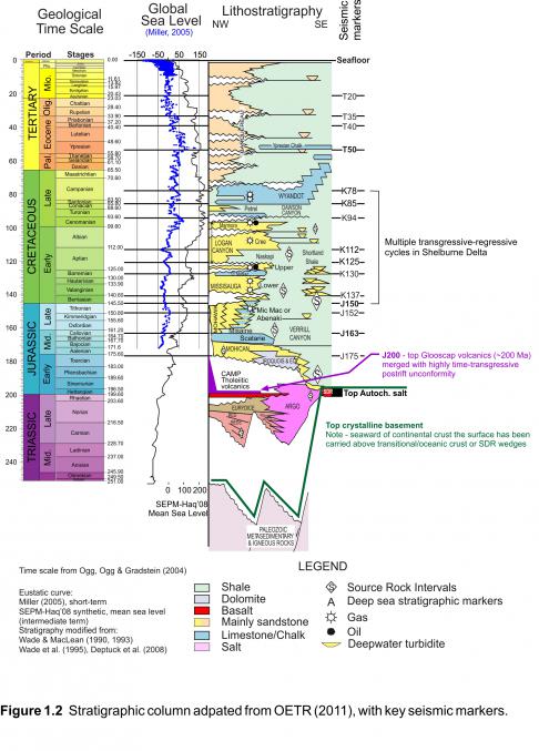
Mohican I-100 (1972) is a key well on the western Scotian Basin as it penetrated a near complete Late Tertiary to Late Triassic stratigraphic succession and recovered nine conventional cores from potential reservoir intervals. It was drilled by Shell on the outer edge of the Scotian shelf in 153 m water to test a large simple four-way closure above a low relief salt pillow as defined by the top Jurassic seismic horizon. A thick shale-dominated upper Tertiary (Pliocene-Miocene) section was first penetrated that unconformably overlies a thin Late Cretaceous section. This was followed by a thick Late to Middle Jurassic succession that had surprisingly little porosity. For the Abenaki Formation, this could be facies-related as the limestones were mostly mudstones with few oolitic or other grainstone lithologies. The early Jurassic Iroquois Formation sandstones and dolomites were tight with the latter invariably anhydritic. At the base of the well, the approximately Sinemurian age Breakup Unconformity is underlain by a thin (79 m) interval of Late Triassic redbeds followed by 28 metres of Argo Formation salts. There were no hydrocarbon accumulations or significant shows in any of the strata penetrated and the well ended at 4388 m TD in Argo salts.
Petro-Canada Moheida P-15 (1977) was drilled in close proximity (~20 km NE) of Mohican I-100 in 112 m water. It too was designed to test potential dolomite reservoirs in the Early Jurassic Iroquois Formation in a simple structural closure above a basement feature. This large (~83 km2) elongate feature was defined by a seismic horizon interpreted as the top Iroquois. The well was drilled on the feature’s crest and encountered a similar stratigraphic succession to I-100 but with a thicker Cretaceous interval. The Late Cretaceous Logan Canyon Formation was shale dominated and while much thinner, the Missisauga Formation was capped with a thick porous fluvial sandstone though with no shows. The underlying Late Jurassic Abenaki Formation was composed mostly of lime mudstones but with better developed oolitic grainstones though the latter were tight. Some modest porosity was present in the targeted Iroquois Formation sandstones though the dolomites were tight. The postrift unconformity at 3848 m capped the remaining 445 m of Mohican to Eurydice Formation tight redbed sediments in which the well ended at 4293 m. No hydrocarbon shows were present in the well.
Chevron-Petro-Canada-Shell Acadia K-62 (1978) was drilled to test a low-relief, narrow, elongate, bank-edge structural closure delineated by seismic. Closure was mapped on the footwall at the top of the Jurassic (Baccaro Mb.) that relied on closure against the main hingeline down-to-the-basin fault. The initial section penetrated was a thick (~2400 m) Tertiary shale succession. A mid-Cretaceous and later lower Tertiary unconformities removed most of the Cretaceous sediments with only ~450 m of Dawson Canyon Formation and younger mudstones remaining. K-62 drilled a complete Abenaki Formation section (Roseway, Baccaro, Misaine, and Scatarie members). Except for the Misaine, the carbonate members were composed of various oolitic limestone lithologies with generally fair to very good porosity. The top Roseway had considerable dolomitization with very good intercrystaline porosity. The expected dolomites of the Early Iroquois Formation were not penetrated (i.e. were deeper) but instead a mixed succession of oolitic grainstones, sandstones and shales of the Mohican Formation with fair to good porosity in the carbonates. No oil staining or significant mud-gas shows were encountered in the well though three DSTs were run in the Abenaki but recovered only formation water. Well TD was at 5287 m in Aalenian to Bajocian age Mohican limestones.
Shell was the first operator to drill on the deep water Scotian slope, with their Shubenacadie H-100 well located in 1476.5 m water depth. This well falls outside the Call parcels but has relevance to plays in the deep water portions of Parcels 5 and 6. The well was designed to test an interpreted Eocene turbidite fan deposit on the paleoslope with a shallower (Miocene) seismic amplitude anomaly as a secondary target. The prognosed Miocene bright spot secondary target was encountered at 2636 m MD and consisted of 25 m of tight, very fine-grained, silty sandstone with no shows. The age of this sand is believed to be Early Pliocene rather than Miocene. Unfortunately, the sonic and density log readings across this zone are questionable due to poor hole conditions (washout). However, the resistivity logs, sidewall cores and cuttings all indicate that the zone is tight. The well’s primary target zone consisted of early Tertiary to Late Cretaceous age shale, tight limestone and marl. No reservoir quality sands were encountered though four conventional cores were cut. The well was drilled to a TD of 4200m MD reaching the Middle Cenomanian upper Logan Canyon equivalent. Subsequent mapping has indicated that the interpreted fan was an erosional remnant below the Base Tertiary (Paleocene to Eocene) unconformity. The Shubenacadie structure is one of the larger remnants separating two divergent channel-dominated areas, which contributed to it resembling a constructional fan on the older seismic. The main exploration implication, also confirmed in the earlier Shelburne G-29 well, was that the Tertiary fan play remained tested.
Husky-Bow Valley Glooscap C-63 (1984) was designed to test a ~50 km2 drape closure over a basement high in the Mohican Graben in 122 m water. The feature relied on some modest fault seal on the eastern flank that is defined on horizons interpreted as the tops of the Scatarie Member, Iroquois and Eurydice formations. The primary target horizons were siliciclastics and dolomites of the Middle-early Jurassic Mohican and Iroquois, and Late Triassic Eurydice formations. Secondary targets were within the shallower Abenaki (carbonate) and Logan Canyon (siliciclastic) formations. The Tertiary (Banquereau Formation) and Cretaceous (Wyandot, Dawson Canyon, Logan Canyon and Missisauga formations) units were present as prognosed and there were few reservoir quality sands in the latter formation. The underlying Abenaki Formation limestones were also tight, and sandstones of the Mohican and Iroquois formations had some fair porosity. A surprise was the presence of 152 m of tholeiitic basalts of earliest Jurassic age at the postulated top Eurydice Formation and beneath this salt of the Argo Formation. Thus the well results (and later seismic mapping) revealed the interpreted basement feature was in fact a salt pillow of Late Triassic age. C-63 was devoid of any hydrocarbon shows and thus terminated at 4542.5 m in Argo Formation.
Husky-Bow Valley next drilled Evangeline H-98 (1984) to evaluate a shallow anticline along the edge of the shelf in 174 m of water. The structure is a narrow, elongate rollover anticline with fault-dependent closures mapped at the interpreted top Logan Canyon Formation (~29 km2 closure) and near top Naskapi Member (~48 km2 closure). Potential gas reservoirs were expected in the fluvial-shallow marine sandstones of the lower Logan Canyon (Cree Member) and upper Missisauga formations. After penetrating the Tertiary and Late Cretaceous Wyandot Formation chalks, the well entered a thick succession of shales and siltstones of the Dawson Canyon and Logan Canyon formation. No significant sandstone reservoirs were encountered, however two gas and high gravity oil (condensate) shows were found in the Logan Canyon Formation equivalent (Cree Member). The uppermost (4022-4070 m) was found in a Late Cenomanian age MFS interval of fossiliferous, sandy lime mudstones with total gas units ranging from 1000-3300 TGU with associated oil (condensate) in drilling mud. The deeper show was in fractured shales (4801-4802 m @ 1400 TGU) accompanied by a drilling break. When compared to the seismic profiles it appears likely that this interval intersected a large listric fault. The well did not reach the targeted Missisauga Formation and was ended at 5044 m and was not tested.
The Petro-Canada Albatross B-13 well (1985) was drilled on a pronounced structural high at the edge of the Abenaki bank margin on the deep water Scotian Slope in 1341 m water. Like Shubenacadie H-100, this well also falls outside the Call parcels but has relevance to plays in the deep water portions of Parcels 5 and 6. The feature is a long (14 km), narrow (~1.5 km) closure with an estimated 250 m vertical relief mapped at the top Abenaki (Baccaro). It is sealed on the seaward side by a basin-dipping normal fault. Target horizons within the Abenaki Formation were defined by high amplitude reflections interpreted to be porous oolitic and reefal carbonate reservoirs. Beneath the thick (~1000 m) of Tertiary age Banquereau Formation mudstones about 1200 m of Abenaki Formation carbonates were penetrated, with most of the Cretaceous succession removed by Tertiary erosion events. The upper half of the formation was composed of oolitic grainstones some of which were dolomitized. Poor to fair porosity was common in this section but with no significant shows. Two mud gas peaks of ~100 TGUs were recorded at 3434-3440m and 3012m with partial loss circulation occurring over the sections but DSTs were not attempted. The basal half of the Abenaki was mostly tight lime mudstone though with some good porosity in several dolomitic zones. The well went through about 100 m of the Callovian Misaine Member shales and siltstones and ended at 4047.5 m TD.
EnCana Torbrook C-15 (2003) was the most recent well drilled in the western half of the Scotian Basin and was the third well in the region to test the Tertiary fan play on the deep water Scotian Slope (1675 m water depth). The primary target was an interpreted Miocene-aged turbidite channel/fan system fed from sediments on the shelf via canyons and deposited in a paleotopographic low. The secondary target was interpreted as an older Miocene fan complex. Two of the canyon feeder systems were identified at the Mohican I-100 and Moheida P-15 well locations updip on the shelf and correlated with the Late Paleogene (Middle Oligocene) relative sea level fall. Both channel/fan systems were defined by amplitude anomalies on 2D seismic. No hydrocarbon bearing reservoir quality sands were encountered in the well. Encana’s primary target was penetrated at 2855 m and consisted of poorly consolidated siltstone and shale/claystone that generated a minor mud-gas response of 50-80 TGU. The secondary target was encountered at 2958 m and consisted of thin, tight, siltstone with no shows. The well ended at 3600 m in early Tertiary sediments. The post-drill interpretation was that that the anomaly was a classic slump feature with no related submarine fan deposition. It is most likely the chaotic internal nature of the slumped mass gave rise to signal attributes that while interpreted as a fan bore no relationship to potential reservoir facies.


