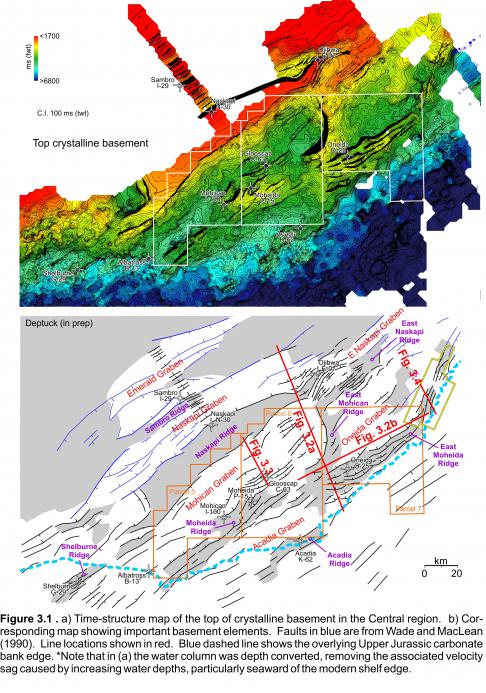
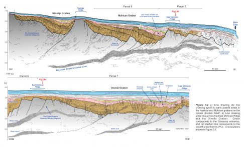
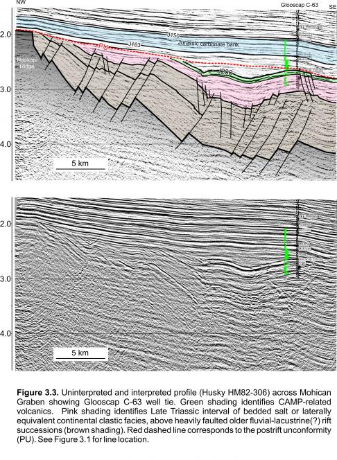
In the landward portion of Figures 3.1 and 3.2a, a prominent angular unconformity separates underlying synrift strata and eroded basement elements (like the Naskapi Ridge) from later onlapping and draping postrift reflections. This erosional surface corresponds to the time-transgressive ‘postrift unconformity’ widely described in most of the Newark-style rift grabens across offshore eastern United States and Canada (e.g. Grow et al. 1983; Manspeizer 1988; Hutchison and Klitgord 1988; Poag, 1991). On the central Scotian Shelf, strata below this surface were penetrated in Glooscap C-63, Moheida P-15, and Mohican I-100 – all in the Mohican Graben – and further landward at Sambro I-29 (Figure 3.1).
Glooscap C-63 encountered a 152 m thick interval of tholeiitic basalt flows that is geochemically indistinguishable from CAMP-related basalts like the North Mountain Basalt exposed along the shores of the Fundy Basin (Wade and MacLean, 1990; Pe-Piper et al. 1992). North Mountain Basalts have a known age of ~201 Ma (Kontak and Archibald 2003) and hence approximate the Triassic-Jurassic boundary. The Glooscap volcanics produce a strong, distinct seismic marker that is conformable with underlying strata (Figure 3.3). It has been correlated throughout parts of the Mohican and Oneida grabens, as well as landward into the Naskapi Graben. In landward areas it has been heavily eroded by the postrift unconformity; further seaward it is commonly located 500 to 700 ms (twt) deeper than the postrift unconformity. This is because later periods of extension (an inversion) dropped the volcanic layer below the level of regional erosion.
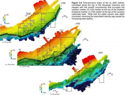
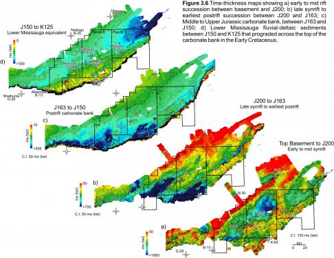
If the postrift unconformity is carried ‘low’, along the conformable Glooscap volcanic reflection, a more regional surface is produced that corresponds to our J200 surface (Figures 3.3, 3.5a). This surface separates pre-CAMP strata below (Triassic and older) from post-CAMP strata above (Early Jurassic and younger). A time-thickness map between J200 and the top of basement shows the distribution of Triassic or older rift basins, partly eroded by the postrift unconformity (Figure 3.6a). This early rift succession locally exceeds 1.8 sec (twt) or > 4.4 km thick (using 4.9 km/s velocity for synrift clastics proposed by Wade and MacLean, 1990). The deepest rift deposits form a tightly faulted succession containing widespread bright amplitude reflections that can be correlated between rift basins (green interval in Figure 3.2). These may correspond to older synrift volcanics or lacustrine facies, but calibration is not available to confirm this. Overlying strata are mixed in character, ranging from low amplitude discontinuous to high amplitude continuous reflections, but like the underlying interval, they are generally offset by numerous smaller scale faults (brown interval in Figure 3.2).
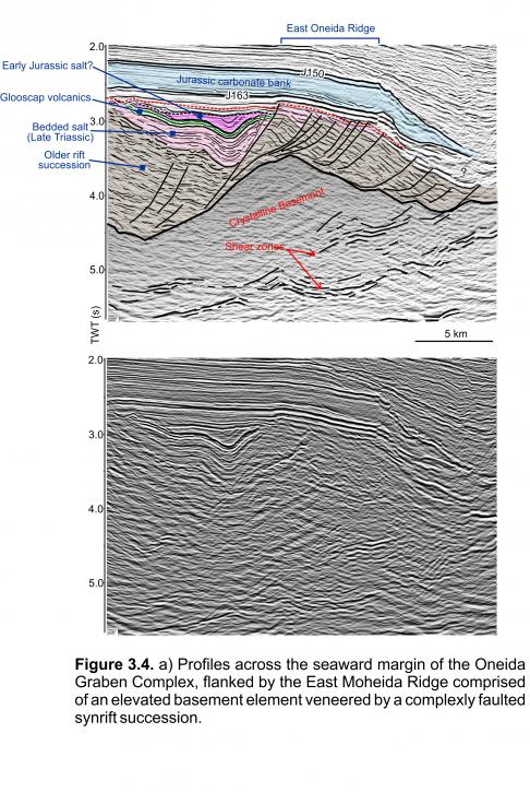
In the Oneida and Mohican grabens, there is a very abrupt upward change into a layered succession of moderate amplitude continuous reflections capped by the Glooscap volcanics (Figures 3.3, 3.4). The interval drapes or onlaps underlying faulted strata, and is largely unaffected by synsedimentary faults (i.e. faulting in this interval post-dates deposition). This distinct interval appears to be the only part of this Triassic synrift succession (beneath the J200 surface) that has been calibrated in the Mohican Graben. At the base of Glooscap C-63, this layered interval corresponds to a 441 m thick interval of Late Triassic (Rhaetian to late Norian; Weston et al. 2012) bedded salt. The layer is made up of salt interbedded with meter-scale dolomite, red dolomitic shale and siltstone beds, and one 40 m thick red shale to siltstone dominated interval located between 4323 and 4363 m. A similar 55 m thick shale to siltstone dominated interval caps the bedded salt succession between 4046 m and 4101 m. Moheida P-15 encountered a 255 m mixed clastic succession of the Eurydice Formation that, based on seismic correlation, appears to be a laterally equivalent facies of the bedded salt at Glooscap C-63. Mohican I-100 encountered a thin (<100 m) interval of probable Late Triassic shale with the well bottoming a few meters into probable Late Triassic salt (Weston et al. 2012). As such, only the shallowest <450 m of this potentially >4.4 km thick succession has been penetrated in wells, and only in the Mohican Graben. No wells penetrate synrift strata in the Oneida Graben.
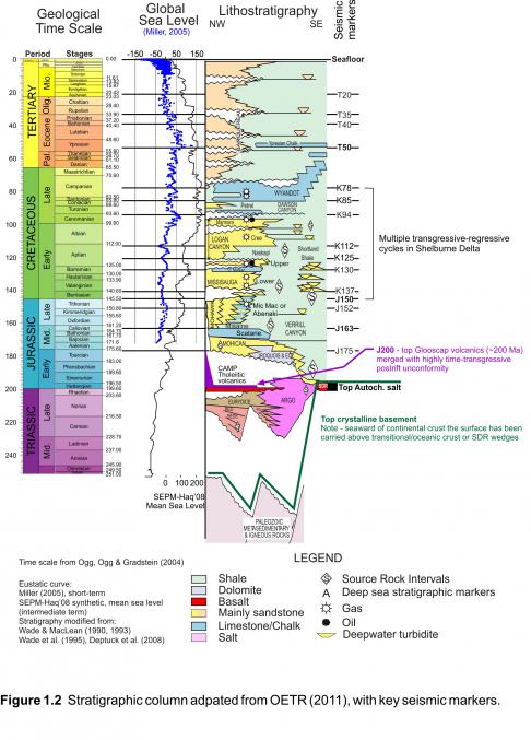
A time-structure map on the J200 surface reveals that the Glooscap volcanics and the underlying bedded salt were folded and faulted into long and narrow northeast trending basins adjacent to the Moheida and East Moheida ridges (Figure 3.5a). The J200 surface has a substantial amount of relief (more than 700 ms twt in some places). Much of this relief developed through rejuvenated extension, and inversion, after emplacement of the Glooscap volcanics, consistent with Withjack et al (1998) who suggested rifting continued after CAMP along this part of the Atlantic margin. A time-thickness map between the relatively flat-lying Middle Jurassic J163 marker (top Scatarie Member) and the rugose J200 surface indicates that earliest Jurassic to Callovian strata were preferentially preserved along these long and narrow basins (Figure 3.6b). The basins broaden and deepen to the southwest towards the mouths of the Mohican and Acadia grabens where salt expulsion provided accommodation for late synrift and postrift strata.
There is a noticeable change in the seismic character – from the well layered bedded salt interval at Glooscap C-63 to more incoherent and chaotic seismic facies towards the mouths of the Mohican and Acadia grabens. This is interpreted to reflect a lateral facies change to more massive salt where rift subsidence was greatest. In addition, on some seismic profiles there appears to be a second younger interval of salt above the Glooscap volcanics (i.e. Early Jurassic salt), but further seaward it is not possible to distinguish these two salt intervals. A conspicuous weakly bedded to transparent interval is also present in the Oneida Graben above the folded Glooscap volcanics (Figure 3.4). Acoustically it is quite similar to intervals of autochthonous salt mapped elsewhere on the margin. A final period of extension postdates these deposits, and the remaining relief within the Mohican, Acadia, and Oneida grabens was infilled by Mohican or equivalent Iroquois facies (Figure 1.2; Wade and MacLean, 1990). A more detailed account of the development of these rift basins is currently in progress (Deptuck, in prep).
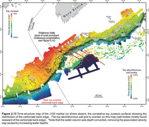
The overlying Middle to Upper Jurassic carbonate platform developed above the synrift to early postrift deposits described above. Its seaward edge parallels and directly overlies the East Moheida and Acadia ridges, but cuts obliquely across the Moheida and Shelburne ridges. Widespread detachment of younger (mainly Jurassic) postrift cover strata took place in areas where underlying salt was thickest – principally at the mouths of the Mohican and Acadia grabens. Continued expulsion of salt into the Late Jurassic probably accounts for the increased thickness of the carbonate bank above these regions (Figure 3.6c). One large diapir pierces Jurassic and Cretaceous strata southwest of Mohican I-100 (Figure 2.13; Deptuck 2011a). The salt at the mouths of these grabens appears to have welded out (at least on the shelf) by the Early Cretaceous when an influx of clastic sediment from the northeast drowned the carbonate bank (lower part of the Missisauga Formation; Figure 3.6d).


