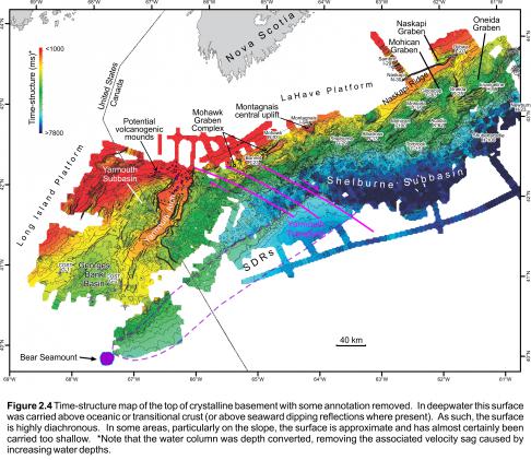
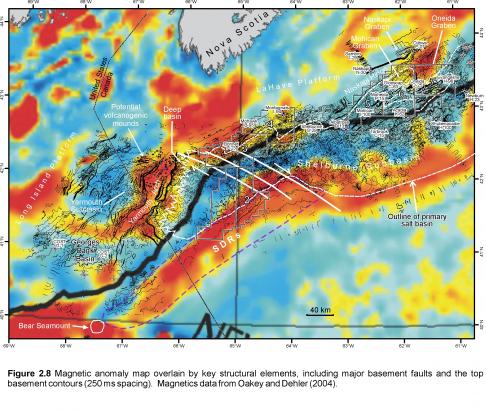
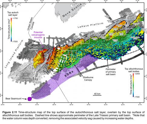
Several observations infer that an important NW-SE trending strike-slip margin trends obliquely through the southwestern Scotian margin (Figures 2.4, 2.8, 2.11):
- A greater than 60 km right-lateral offset of the Yarmouth Arch relative to the edge (hinge) of the LaHave Platform immediately to its east;
- a corresponding sharp, more than 60 km right-lateral offset in the seaward limit of the autochthonous salt basin;
- the presence of an anomalously deep salt basin where the Yarmouth Arch intersects the LaHave Platform;
- clustering of volcanoes or volcanic vents along the northern parts of the Yarmouth Arch
- the abrupt change in the density, style, and distribution of salt bodies between Shimeld’s (2004) salt provinces I and II; and
- the recognition of clear offsets in the East Coast Magnetic Anomaly (ECMA) that align with the offset along the seaward boundary of the primary salt basin.
The matching 60+ km right-lateral offsets in the landward versus seaward boundaries of the salt basin, in particular, implies that either a single heavily curved strike-slip boundary, or a series of smaller scale slightly curved strike-slip faults, accommodated the offset in the salt basin. A similar transfer fault has been schematically proposed by both Manspeizer (1988) and Welsink et al. (1989), but the basis for this fault is not discussed in any detail. The distribution of several en-echelon deep-seated faults identified on seismic profiles across this region implies that a wider region of strike-slip faulting accommodated the offset, rather than a single fault. Some of these faults sole out along and in some cases even offset the Moho. As such, this wider region of strike-slip faulting is similar to the situation along the southern Grand Banks (the southwest Grand Banks transform margin described by Pe-Piper and Piper 2004).
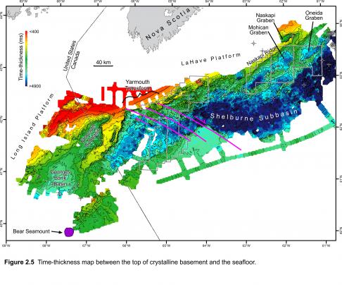
We herein refer to this strike-slip accommodation zone as the Yarmouth Transform Fault Zone (or the Yarmouth Transform for short), and similar to Manspeizer (1988) and Welsink et al (1989) interpret it as a splay coming off the South Atlas fault zone (see figure 3.1 of Manspeizer 1988 and figure 20 of Welsink et al. 1989). Right-lateral offset across the curved Yarmouth Transform helps explain the more northerly-trending basement grain to its west (including the Yarmouth Arch), compared to the dominantly northeast basement fabric to its east. A small amount of clockwise rotation south of the transform re-aligns the basement fabric on both sides of the transform (Figure 2.5).


