


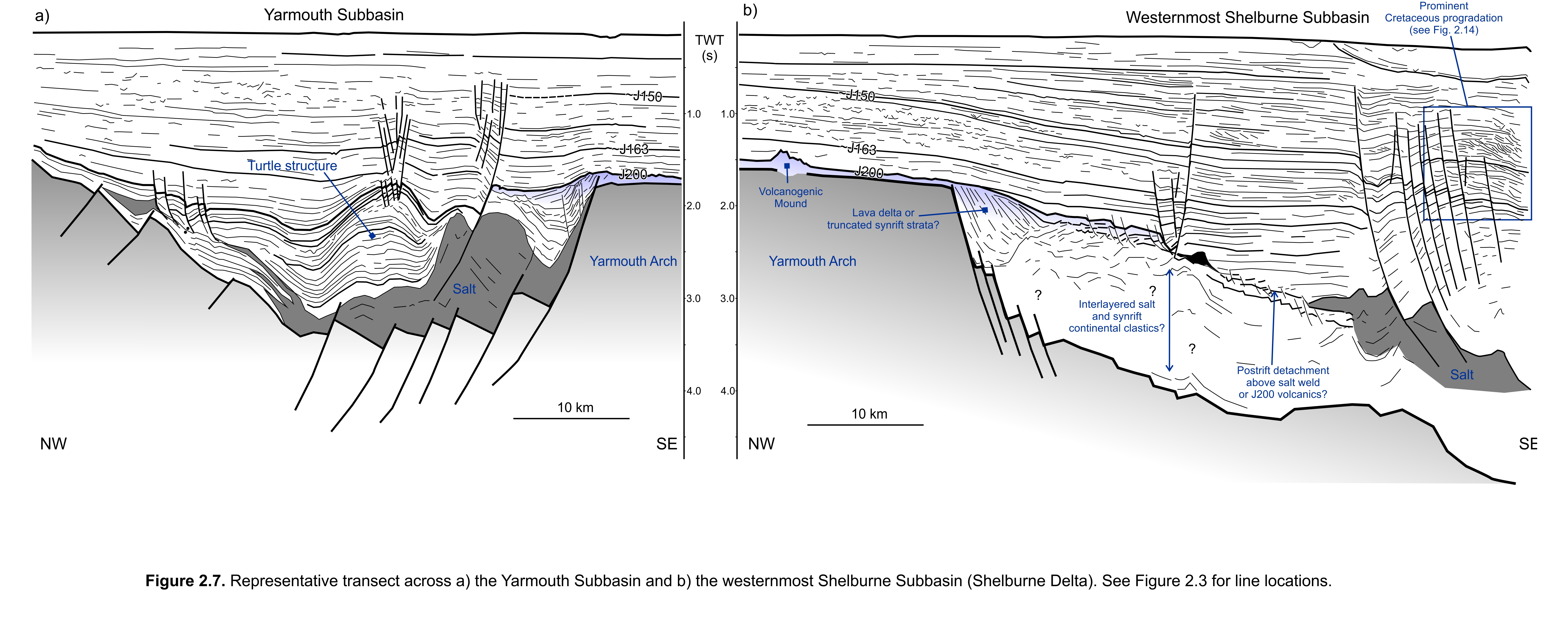
West of the Yarmouth Arch in the northeastern parts of the Georges Bank Basin is a distinct subbasin containing up to 2 sec (twt) of moderately to heavily deformed strata referred to here as the Yarmouth Subbasin (Figures 2.4, 2.5). Its general structure is a complexly faulted half-graben, with the most important border faults dipping towards the west or northwest away from the irregular western margin of the arch (Figure 2.7). The subbasin is up to 52 km wide and 115 km long, with the thickest strata located above the hanging wall adjacent to the Yarmouth Arch or near the centre of the subbasin. Strata thin more gradually towards the west and northwest, away from the arch, onto the faulted eastern parts of the Long Island Platform (sensu Wade and MacLean 1990).
The basin fill is complex, consisting of faulted and folded layered successions as well as deformed transparent to chaotic intervals interpreted as salt bodies. The latter are generally rooted to an autochthonous layer located above faulted basement, and range from pillows or salt anticlines to poorly developed salt stocks or walls. Some chaotic salt intervals pass laterally into folded and deformed layered successions, which could indicate that the primary salt was originally interbedded with other lithologies. Early fill above the salt is generally layered. An impressive turtle structure occupies much of the basin, with most of the salt expelled towards the Yarmouth Arch (Figure 2.7). A grid of the top salt surface shows the distribution of isolated north to northeast trending diapirs, as well as more complex salt structures that rose up along eastern border faults, adjacent to the Yarmouth Arch (Figure 2.11). In addition to turtle structures, layered successions elsewhere above the salt are also commonly folded, and an angular unconformity is present where these deformed intervals were truncated by the postrift unconformity just west of the Yarmouth Arch.
The fill of the Yarmouth Subbasin has not been penetrated by any wells, but correlation into Cost G-2 ~50 km to the south indicates that much of the early basin fill is older than the Early Jurassic(?) Argo Salt encountered at the base of this well (Schlee and Klitgord 1988; Poppe and Poag 1993). Some workers have speculated the fill of the Yarmouth Subbasin could be as old as Carboniferous, with salt corresponding to the basal Mississippian Windsor Group (e.g. Wade and MacLean 1990). However, it is equally possible the basin formed in the Permian or even in the Triassic, with the salt here being equivalent to or slightly older than the Late Triassic Osprey Formation encountered in wells on the southern Grand Banks (McAlpine 1990). Although the maximum age of the salt in the Yarmouth Subbasin cannot be known with the available data, it is clear that some of the early salt structures were later reactivated, and continued to influence sedimentation even after the postrift unconformity. Numerous faults sole out above or along the flanks of salt diapirs, offsetting Jurassic and even Lower Cretaceous strata, and at least one growth interval involving probable Jurassic strata produced a distinct 40 km long and < 5km wide north to northeast trending trough shaped salt-withdrawal basin in the northern parts of the Yarmouth Basin (Figure 2.10). As such, postrift salt tectonics in this basin, as with the basins east of the Yarmouth Arch, is prevalent. To the east however salt tectonism is more clearly linked to Late Triassic (Osprey) or earliest Jurassic (Argo) salt (e.g. Shimeld 2004; Deptuck 2010, 2011a; Kendell 2012).