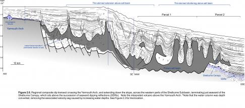
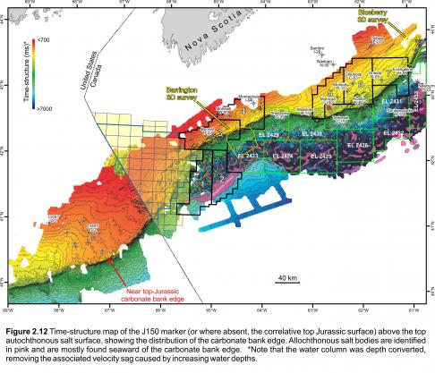
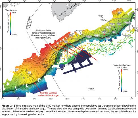
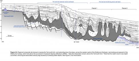
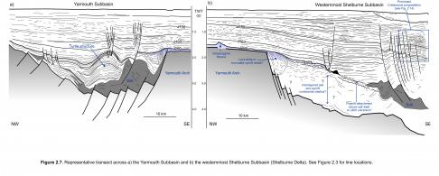
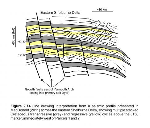
Postrift cover strata west of the Yarmouth Transform form a thin-skinned linked system above the primary salt basin, characterized by a landward extensional domain and a seaward compressional domain (Figure 2.6). A time-structure map along the top Jurassic seismic marker (J150) shows the location of thin-skinned extensional faults in the landward part of this system (Figures 2.12, 2.13). They extend in an arc that parallels the Yarmouth Arch continuing into the western parts of the Mohawk Graben Complex. Salt rollers dominate this region, but locally salt diapirs are also present. The profile in Figure 2.6 crosses a more salt-rich region immediately adjacent to the northern part of the Yarmouth Arch where clear downbuilding and extensional growth faulting took place. One salt diapir in this proximal region rises nearly to the seafloor (just out of the plane of the seismic section). A profile further to the southwest shows a series of tightly spaced faults that sole out along a salt weld and within the landward parts of the primary salt basin (Figure 2.7). Salt expulsion from this region appears to have driven by gravity spreading in an area of increased sedimentation associated with the Shelburne Delta (Wade and MacLean 1990). This delta system was long lived with numerous transgressive-regressive cycles recorded in Middle Jurassic to Upper Cretaceous strata, across these growth faults. The clearest progradation, however, appears to be within Cretaceous strata above the J150 marker (region identified in Figures 2.13, 2.14).
The density of salt diapirs increases down the slope. Downbuilding above the main part of the autochthonous salt basin appears to have produced a series of minibasins separated by complexly deformed salt diapirs. Isolated salt stocks and more elongated salt walls are generally rooted to the primary salt layer (Shimeld, 2004). Many of these salt bodies were reactivated and squeezed well into the Cenozoic, and salt overhangs and pinched stems are common (Figure 2.6). Seaward of the salt basin is a 10 to 25 km wide and ~85 km long salt tongue canopy referred to as the Shelburne Canopy (Deptuck, 2011a). It was expelled up and over the SDRs, advancing most rapidly across the paleo-seafloor in the Middle to Upper Jurassic (right side of Figure 2.6). It ceased its seaward advance at the end of the Jurassic, and today sits immediately above the ECMA (Figure 2.11). Its timing is similar to the Banquereau Synkinematic Wedge on the eastern Scotian Slope (Deptuck et al. 2014).
Unlike the gravity spreading system to the west (where sedimentation rates were high), salt tectonics east of the Yarmouth Transform were driven primarily by gravity gliding in response to margin tilting, and not sediment loading (Deptuck 2010, 2011a). The landward parts of the salt basin here are dominated by slabs of Jurassic and to a lesser extend Cretaceous cover strata that detached and slid down the slope above salt pillows and salt rollers, or a primary salt weld. This produced the ‘slope detachment province’ (Deptuck 2011a), which continues along the slope east of the Yarmouth Transform for approximately 350 km. Taller salt stocks and walls are generally restricted to the slope seaward of this region, where downbuilding within subcircular to elongated minibasins expelled salt from the thickest parts of the primary salt basin. A detailed account of the salt tectonics east of the Yarmouth Transform is presented in Deptuck (2011a).


