


The southwestern Scotian margin, stretching from Georges Bank across the Northeast Channel, and to the LaHave Bank (Figures 1.1, 2.1) is the most lightly explored area of the Scotian Basin. Limited coverage of modern seismic data-sets, especially on the shelf, coupled with very sparse well control, also makes this one of the most poorly understood offshore regions of Nova Scotia. Only four wells provide stratigraphic calibration in an area covering more than 28 000 km2. With Montagnais I-94 (Parcel 4) penetrating the central uplift of an Eocene impact crater (see Deptuck and Campbell, 2012), only Mohawk B-93 (Parcel 4; drilled in 1970) and Bonnet P-23 (Parcel 3; drilled in 1984) provide calibration for Mesozoic strata on the southwestern Scotian Shelf (see Tables 1.1 to 1.3 inclusive). A fourth well, Shelburne G-29 (drilled in 1985) provides the only stratigraphic calibration of the southwestern Scotian Slope. It lies along the easternmost edge of study area, more than 30 km east of Parcel 4, and provides little calibration of pre-Cretaceous strata. Additional calibration is available roughly 250 km southwest of Bonnet on the U.S. side of Georges Bank, where ten wells were drilled on the shelf in the 1970’s and early 80’s (Figure 2.1).
Exploration started on the southwestern part of the margin in the late 1960s with the acquisition of regional seismic and gravity-magnetic data on the Scotian Shelf / LaHave Platform, followed by two wells in the early 1970s. Exploration along the Abenaki carbonate reef complex and along the upper Scotian Slope resulted in two additional wells in the 1980s. Large basin-scale regional seismic programs were completed in the late 1990s with emphasis on the deep water slope, and while the deep water slope was licensed by industry and some additional seismic acquired, no wells were drilled. Figure 2.2 shows the distribution of seismic data acquired since 1970, and the location of wells.
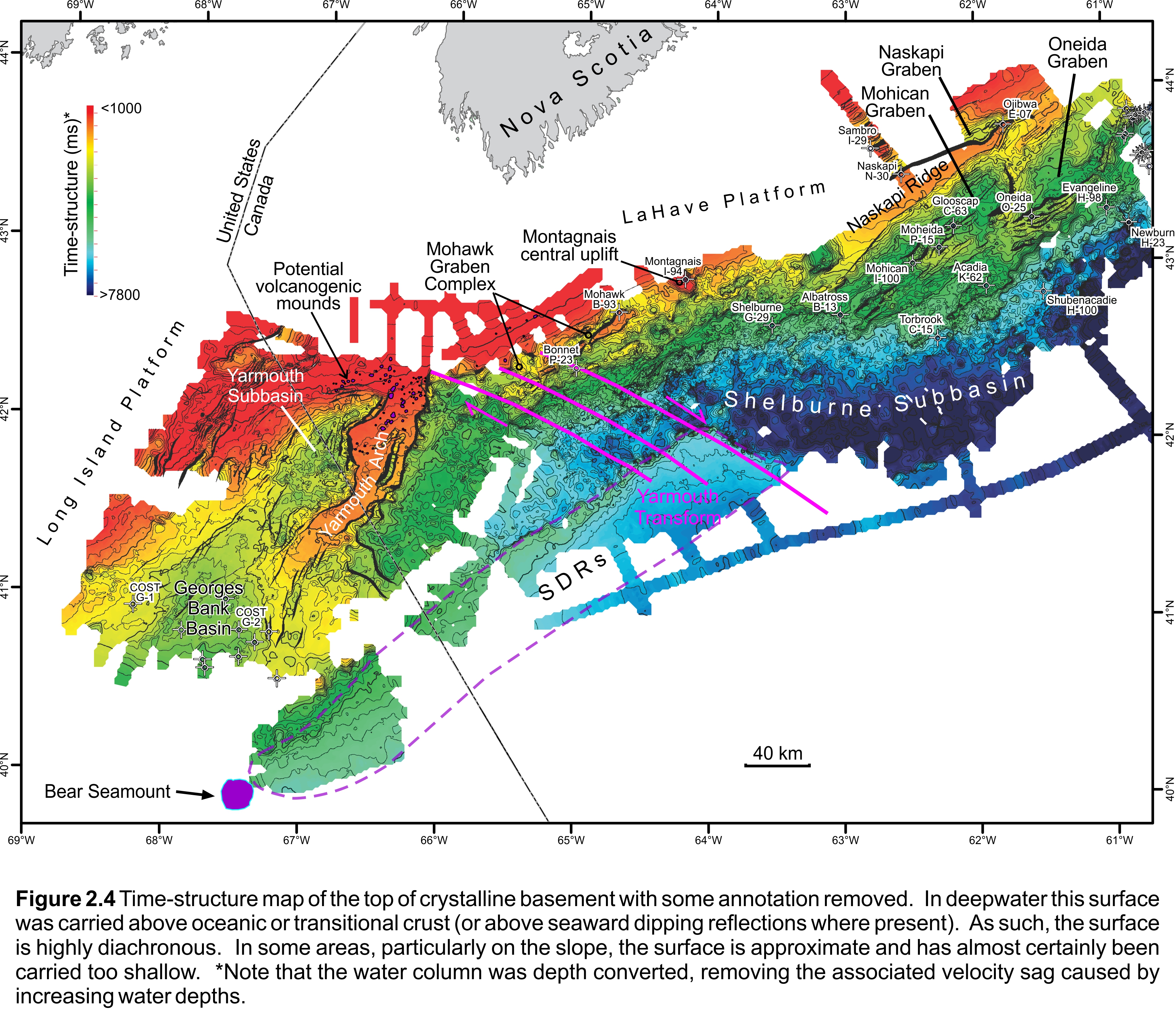
The first well in the western region was Shell Mohawk B-93 (1970) and was also the fifth drilled in the Scotian Basin. It is located in 117 m water and was designed to test a drape feature above a basement horst block inboard of the basin hingeline fault (Figures 2.3, 2.4). Four-way simple closure was mapped at the top of the Late Jurassic Abenaki Formation and reservoirs were expected within the Abenaki and underlying (then unnamed) fluvial siliciclastics. Some minor porosity was present in Abenaki oolitic limestones though the dominant underlying coarse-grained fluvial sandstones (Mohican Formation type section) had good to excellent porosity but no oil or gas shows. The well bottomed in Middle Devonian granitic basement at a total depth of 2124 m.
Another large basement feature was tested by the Union Montagnais I-94 well in 1974 (Figures 2.3, 2.4). 2D seismic data defined a drape feature with presumed simple four-way closure on an isolated basement high at the edge of the basin hingeline fault. The high was surrounded by a depression and a complexly faulted outer margin. The well was spudded in 113 m water depth and penetrated a thin clay-dominated Tertiary section followed by Early Cretaceous Logan Canyon Formation fluvial sandstones and shales. Well TD was at 1644 m in highly deformed Cambro-Ordovician metaquartzites of the Meguma Supergroup. Subsequent petrographic study of the basement core and the feature’s structural architecture revealed it was an impact crater with an event age of ~50.5 Ma (Early Eocene). A shallow minor gas show was found at 377.6-383.7 m in unconsolidated Quaternary gravels but was not tested.
The Petro-Canada Bonnet P-23 well (1984) is the westernmost well in the Scotian Basin. It was drilled to test a large (~70 km2), elongate, fault-bounded structure located about 6 km inboard of the highly faulted bank margin in 133.5 m water. Closure was mapped at the interpreted Late Jurassic Mohawk seismic horizon, with its fluvial sandstones the primary reservoir target. About 1700 m of Tertiary mudstones are above several base Tertiary unconformities that cut down through the Cretaceous section leaving a thin (~25 m) interval of Late Cretaceous sandstones and shales. This was followed by the entire Middle to Late Jurassic Abenaki Formation (Roseway-Baccaro-Misaine-Scatarie members; Figure 1.2). The carbonates are dominately oolitic limestones and minor dolomites having occasional fair (inter-oolitic), to very good (intercrystalline dolomitic) porosity in lagoonal facies mudstones. No reef-related facies were present. Rare porosity was found in the thick underlying Early Jurassic Iroquois Formation dolomites though the basal 450 m of this formation was not accurately evaluated due to extensive lost circulation zones, incomplete mud-gas logging, lost mud and sample returns, etc. that may be the result of enhanced porous intervals or the presence of several large faults in this section. Four gas peaks under 100 TGU were encountered here and minor oil staining in two samples but no tests done. Expected coeval Mohawk or Mohican sandstones were not present and the well TD was at 4336 m in the Iroquois Formation.
The fourth well, Shelburne G-29 was drilled by Petro-Canada in 1985 and is outside of the Call parcels, 30 km east of Parcel 4. It was spudded in 1153.5 m water with the primary target an interpreted turbidite fan of Paleocene to possibly Maastrichtian age. The secondary target was an underlying southwest-plunging structural nose of the Jurassic Abenaki carbonate margin (Middle Jurassic Scatarie Member) and dolomitic Iroquois Formation above a salt pillow. A few minor sandstones with scattered fair to very good porosity were encountered in the upper Tertiary. In the target interval (later confirmed to be the Late Cretaceous Wyandot and Dawson Canyon formations), the suspected turbidite fan was found to be a succession of limestones, marls and shales, with the remaining interval being almost entirely shale. The well just tagged the top of the Abenaki Formation (Baccaro Member) and a core was attempted. However, after cutting 14.5 m of core the drill string became stuck while pulling out of the hole and following unsuccessful attempts to retrieve it the well was abandoned at a TD of 4005.5 m. No reservoirs or hydrocarbon shows were present.