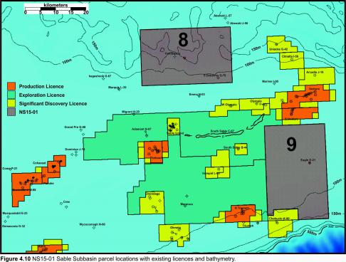
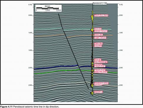
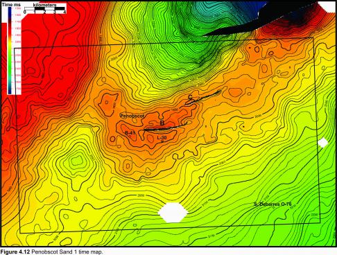
Parcel 8 flanks the northern extent of the Sable Subbasin in present day water depths varying from 50 m to 250 m and encompasses the Penobscot oil discovery (Figure 4.10). The initial well on the Penobscot structure, L-30, was drilled by Petro-Canada-Shell in 1976 to a depth of 4237.5 m in 138 m of water. Hydrocarbons were recovered by Repeat Formation Tester (RFT) from four lower Missisauga sands overlaid by the O marker. A seismic dip line through the L-30 well indicates the Sand 1 marker in blue (Figure 4.11). A time map interpreted on Sand 1 shows why Shell-Petro-Canada drilled B-41 3 km to the northwest in 1977 considering it to be up-dip on the same structure as L-30 (Figure 4.12). The B-41 well reached a total depth of 3414 m in 118 m of water but no significant hydrocarbon shows were encountered and no formation tests were run. The stratigraphic tops in B-41 were within 10 m of the tops in the L-30 well suggesting that B-41 was not substantially up-dip of L-30. Recent 3D reprocessing and depth conversion demonstrate that B-41 was probably drilled into a separate closure.
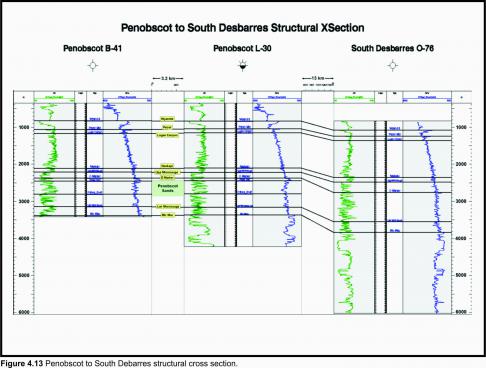
Approximately 13 km to the southeast from L-30, Shell Canada Resources drilled South Desbarres O-76 in 69 m of water on a separate structure on April 16, 1984. The well reached TD within the Mic Mac Formation at a depth of 6041 m. No significant hydrocarbon bearing zones were encountered and the well was abandoned on Oct. 13, 1984. A regional cross-section shows the correlation of several key geological horizons between Penobscot and South Desbarres (Figure 4.13).
After the licence was relinquished by Shell, Nova Scotia Resource Limited (NSRL) obtained an Exploration Licence over the Penobscot prospect in 1989 and acquired 66 km2 of 3D seismic data (CNSOPB program number NS24-N011-001E). The interpretation report for this survey, completed in 1991, including synthetics, depth conversions and maps, is available through the Geophysical Data section under the Data tab on the Call for Bids website. A second report completed in 1992 that included further mapping and reserve estimates is also available. This report identified additional potential northeast of the original mapped Penobscot prospect that has yet to be tested.
The Penobscot 3D seismic data is now owned by the Province of Nova Scotia who has made the digital SEGY data available free to the public through the CNSOPB’s Geoscience Research Center (GRC). The Provincial Government also reprocessed this 3D seismic to improve data quality. Instructions for downloading both of these data sets can be found in the Digital Data section. A number of other seismic surveys have been acquired over portions of the parcel since the early 1980s. Interpretation reports are available for most of these programs.
As a result of the NS07-1 Call for Bids, a licence containing the Penobscot field was awarded to Ammonite Corporation under a “promote license” scenario where the 25% work deposit was deferred for 3 years. Ammonite returned the parcel to Crown on December 31, 2012 with no deposit being paid.


