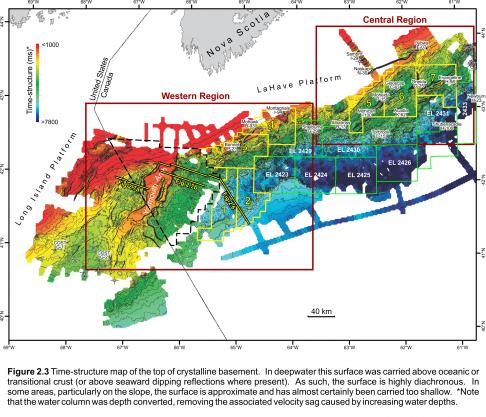
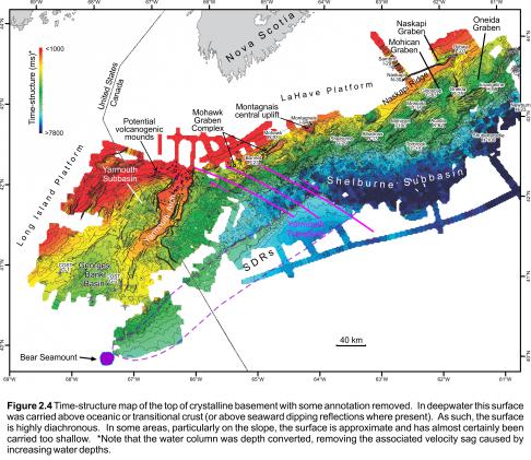
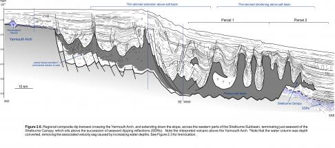
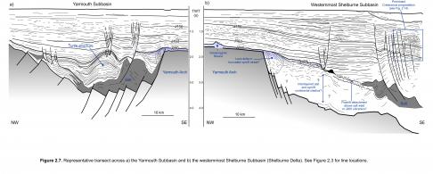
The Yarmouth Arch is the most prominent basement element off southwestern Nova Scotia (Figures 2.3, 2.4, 2.6). It consists of a faulted and segmented basement horst block that separates the Georges Bank Basin to its west from the Shelburne Subbasin to its east. The arch forms a SSW-trending protrusion of crystalline basement that extends at least 150 km from the adjoining LaHave Platform. The 12 to 38 km wide top surface of the Yarmouth Arch is generally flat lying, except where it is offset by normal basement faults or where small volcanogenic features generate local rugosity (described below; Figures 2.6, 2.7). The structure generally narrows, is more deeply buried, and has a lower relief towards the SSW where it is more difficult to map. The Yarmouth Arch is probably composed of Early Paleozoic metasedimentary rocks of the Meguma Supergroup and associated Devonian granites that intrude them, but the basement rocks here have not been directly sampled. Early Paleozoic metasedimentary crystalline basement is confirmed on the Long Island Platform at the base of the Cost G-1 well, 90 km southwest of the Yarmouth Arch (Figure 2.4). On the LaHave Platform, the Meguma metasedimentary rock and granites have been sampled and dated from the base of the Mohawk B-93 and Montagnais I-94 wells located 120 and 175 km northeast of the Yarmouth Arch, respectively (Wade and MacLean 1990; Pe-Piper and Jansa 1999).
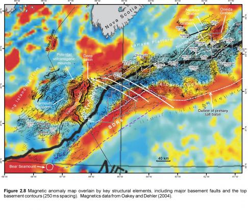
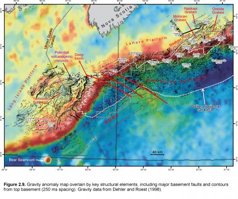
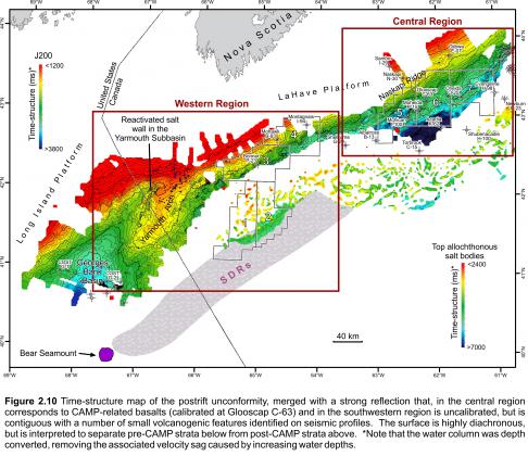
On aeromagnetic data, the arch produces a strong positive magnetic anomaly that closely mimics its planform shape (Figure 2.8). On gravity data, it does not produce an obvious anomaly, but is flanked to the west by a gravity low generated by the Yarmouth Subbasin (described in a following section) and to the northeast by another gravity low generated by a deep basin where the Yarmouth Arch intersects the LaHave Platform (Figure 2.9). A prominent positive shelf edge anomaly (gravity high) lies to its east along much of its length. On reflection seismic profiles, the northern parts of the Yarmouth Arch are veneered by a distinctive high amplitude seismic reflection that continues beyond the edges of the arch, above more heavily deformed strata (Figures 2.7, 2.8). This surface passes laterally into an angular unconformity (collectively referred to as the J200 marker, and shown in Figure 2.6). Its reflection seismic response is similar to that produced by the ~150 m thick CAMP-related lava flows penetrated by the Glooscap C-63 well on the central Scotian Shelf and the subsurface reflection produced by buried Rhaetian age North Mountain Formation tholeiitic basalts in the Fundy Basin. Contiguous with this reflection are a series of positive relief, mounds clustered around the northern parts of the arch (Figures 2.4, 2.6, 2.7, 2.10). Their dimensions (< 70 to 210 ms (twt) tall and up to 4.1 km wide, at the base) and appearance are strikingly similar to Eocene volcanogenic mounds described by Magee et al. (2013) from high quality reflection seismic profiles off southern Australia. The mounded features on the Yarmouth Arch are likewise interpreted as small volcanoes or volcanic vents. Indeed, Figure 2.6 reveals a 900 m wide depression at the centre of the mound interpreted as a central vent, and like the volcanogenic mounds described by Magee et al (2013), saucer shaped reflections interpreted as subvolcanic sills are present beneath some mounds, producing internal reflections within the rocks of the Yarmouth Arch. This implies that the mounds did not simply grow above the Yarmouth Arch, as might be expected if these features were carbonate build-ups.
The strong magnetic character of the Yarmouth Arch (Figure 2.8) combined with its reflection seismic character and the presence of interpreted volcanogenic features, strongly implies that parts of the Yarmouth Arch are veneered by volcanic lava flows. Furthermore, the flows appear to extend several kilometers west and east of the arch where they overlie deformed pre-volcanic synrift stratigraphic successions or merge with the postrift unconformity. The lava flows and other volcanogenic features are tentatively interpreted to be related to the ~200 Ma CAMP episode,. However, the presence of buried Middle Jurassic seamounts at the mouth of the Georges Bank Basin (Wade and MacLean, 1990), and alkalic mid-Jurassic volcanics and ash flows encountered in two Georges Bank wells (Lydonia Canyon 133 and Cost G-2; Hurtubise et al. 1987; Elliott and Post, 2012), raises the possibility that these volcanogenic features could be somewhat younger. Unfortunately the Lower and Middle Jurassic succession is highly condensed or absent above the northern parts of the Yarmouth Arch, making it impossible to discriminate the timing of these features without direct sampling.


