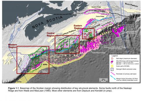
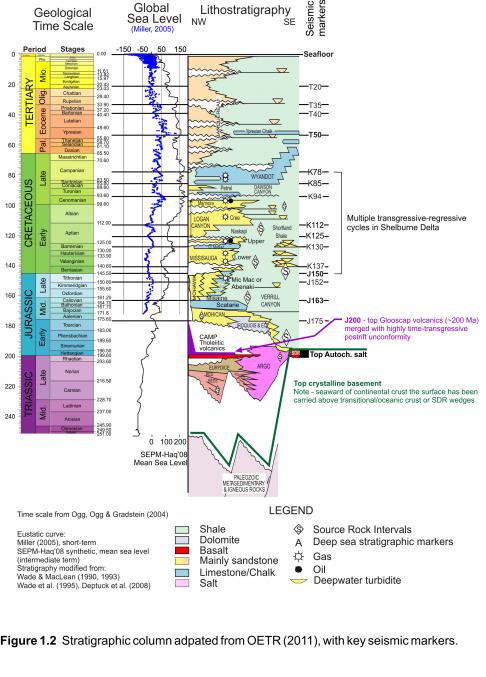
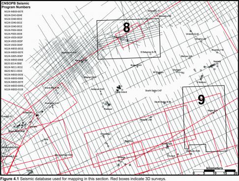
Parcels 8 and 9 are located in the Sable Subbasin where all 23 of offshore Nova Scotia’s Significant Discoveries have been made (Figure 1.1). For a detailed geological examination of the Sable Subbasin, refer to the NS12-1 http://www.callforbids.cnsopb.ns.ca/2012/01/ns12-1-parcels/central-scotian-margin-parcels-12-7-11/regional-overview and NS13-1 http://callforbids.cnsopb.ns.ca/2013/01/content/eastern-scotian-shelf-regional-interpretation call for bids packages. The following abridged regional discussion includes updates and brief overviews from portions of those reports. The CNSOPB has adopted the seismic horizon nomenclature proposed in the Play Fairway Analysis. The Scotian Basin stratigraphic column indicates the key mapped horizons in this section (Figure 1.2). The digital seismic data set used for interpretation and mapping in this section has the 3D survey areas outlined in red (Figure 4.1). The CNSOPB program numbers are listed on this figure.
Rifting
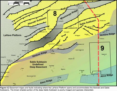
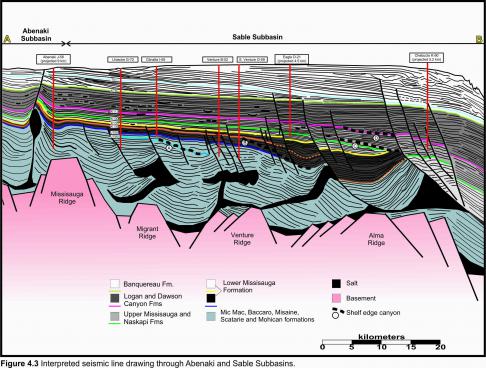
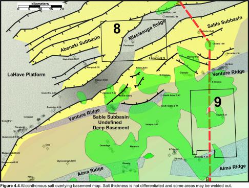
Rifting of the Scotian Margin began in the Middle Triassic and continued into the Early Jurassic forming a widespread region of horsts and grabens throughout the central and northeast Scotian Margin as discussed in detail in call for bids NS13-1. In this study area, basement structuring transitions from the LaHave Platform into distinct basement features such as the Missisauga Ridge which separates the rapidly deepening Abenaki Subbasin to the north with the gradually deepening basement shoulder faults of the Sable Subbasin to the south (Figure 4.2). Basement faults flank the grey shaded basement ridges with darker grey shaded ridges indicating deeper burial. The brown shaded region outlines deeper areas of the Sable Subbasin where significant autochthonous and allochthonous salt, combined with deep burial, makes it challenging to interpret basement. Several deeply buried basement ridges such as the Venture and Alma ridges underlie this area with the prominent Alma Ridge coinciding with a portion of the present day shelf break. An interpreted drawing of a composite north-south seismic line illustrates the basement horst blocks and their influence on subsequent infilling of the subbasins (Figure 4.3). The dashed lines labeled A to D indicate various shelf edge canyon systems as the delta progrades basinward. The location of this line drawing is indicated by the red dashed line in Figures 4.2 and 4.4.
Salt
Autochthonous synrift salt deposition on the Scotian Margin is interpreted to be bounded by the basement highs which then influenced the focusing and early uprising of allochthonous salt bodies. Sediment loading and downbuilding by Early Jurassic systems loaded the salt which was often pinned in the basinward direction by basement ridges. Salt contact with these basement horsts forced the salt to climb vertically through the sedimentary section eventually forming either solitary salt diapirs or canopies (Figure 4.4). The green shaded areas indicate the presence of allochthonous salt but do not differentiate thickness. Portions of these salt regions may be welded out. The strike trend of the allochthonous salt lies in the same south west to northeast trend as the basement ridges.
Jurassic
The Early Jurassic Mohican Formation is the initial post rift fill in the Scotian Basin, followed in the Middle and Late Jurassic by siliciclastics of the Mic Mac Formation and coeval limestone deposits of the Abenaki Formation. This thick Mic Mac section is a significant reservoir for discovered hydrocarbons.
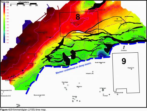
Thick carbonate platforms with fringing reef development are also present during the Middle to Late Jurassic. Carbonate development is highly influenced by the basement architecture. A map on a Kimmeridgian marker (J155) shows an extensive carbonate platformal area shaded red with a steep, rimmed bank edge in the southeast near Panuke that reflects the southern limit of the LaHave platform (Figure 4.5). This carbonate bank edge broadens eastward as the LaHave Platform basement structure opens into several basement ridges. As the Missisauga Ridge plunges deeper to the northeast from the LaHave Platform at Dominion J-14, the carbonate bank veers north towards Grand Pre G-08 and then east towards Marquis L-35. The J155 is deeply buried, heavily faulted due to salt tectonics, and not currently interpreted over the southern portion of this map area.
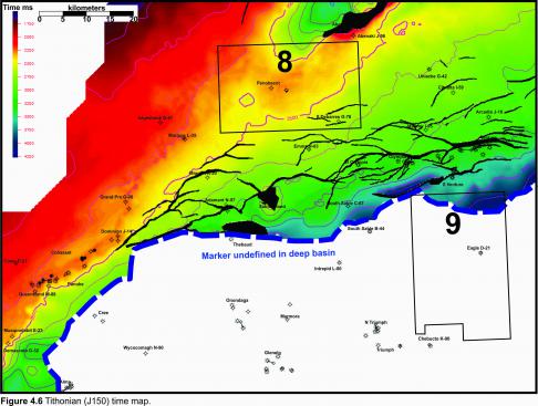
A map on the Tithonian seismic marker (J150) shows a similar stacked, steep, rimmed bank edge near Panuke that continues towards Grand Pre G-08 where the proximity of several basement highs and the LaHave platform results in broadening of the bank edge slope, forming an accretionary ramp that is not rimmed (Figure 4.6). While Marquis L-35 and Kegeshook G-67 are underlain by the LaHave platform, Penobscot on Parcel 8 is influenced by the Missisauga Ridge. The J150 is deeply buried, strongly affected by salt tectonics, and not currently interpreted over the southern portion of this map area.
Cretaceous
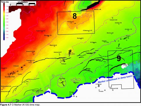
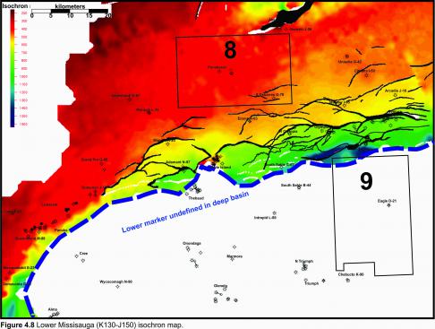
The Missisauga Formation was deposited throughout the Latest Jurassic and Early Cretaceous. This sand rich sequence of fluvial deltaics can be divided into upper and lower members which are separated by an interval of generally thin Hauterivian/Barremian oolitic limestones known as the “O” Marker (K130). The oil reservoir section discovered at Penobscot lies just below the O marker in the Lower Missisauga Formation where structuring results from drape over the Missisauga Ridge (Figure 4.7). Thick deposits of lower Missisauga sediments (K130-J150) are located basinward of the carbonate bank system (Figure 4.8). A number of wells such as those drilled in the West Venture, Citnalta, Olympia, West Olympia, Intrepid and Glenelg Significant Discoveries have encountered considerable reservoir quality sandstone and net gas pay within the Lower Missisauga. Three Sable Offshore Energy Project fields are also currently producing gas from the Lower Missisauga: Thebaud, Venture and South Venture. This isopach continues to thicken southward under Parcel 9.
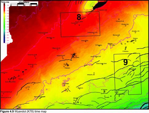
The end of the Cretaceous period in the Scotian Basin saw a rise in sea level, basin subsidence and deposition of marine marls and chalky mudstones of the Wyandot Formation (K78). This surface shows evidence of widespread mass transport system that reworked the chalk and moved it down slope towards the basin as described in Smith et al, Upper Cretaceous mass transport systems above the Wyandot Formation chalk, offshore Nova Scotia (Figure 4.9). This chalk comprises the reservoir at the Eagle gas discovery in Parcel 9 although there is no evidence of mass transport processes within the chalk section at this location.


